FAA INFORMATION EFFECTIVE 19 MARCH 2026
Location
| FAA Identifier: | 1W1 |
| Lat/Long: | 45-37-40.1860N 122-24-15.5210W
45-37.669767N 122-24.258683W
45.6278294,-122.4043114
(estimated) |
| Elevation: | 429 ft. / 131 m (estimated) |
| Variation: | 19E (1985) |
| From city: | 3 miles N of CAMAS, WA |
| Time zone: | UTC -7 (UTC -8 during Standard Time) |
| Zip code: | 98607 |
Airport Operations
| Airport use: | Open to the public |
| Activation date: | 05/1946 |
| Control tower: | no |
| ARTCC: | SEATTLE CENTER |
| FSS: | SEATTLE FLIGHT SERVICE STATION |
| NOTAMs facility: | SEA (NOTAM-D service available) |
| Attendance: | UNATNDD |
| Pattern altitude: | 1229 ft. MSL |
| Wind indicator: | lighted |
| Segmented circle: | yes |
| Lights: | ACTVT MIRL RY 07/25 - CTAF. |
| Beacon: | white-green (lighted land airport)
ACTVT ROTG BCN - CTAF. |
Airport Communications
| CTAF: | 122.7 |
| CLEARANCE DELIVERY: | 121.65 |
| WX ASOS at TTD (5 nm S): | 135.625 (503-492-2887) |
| WX ASOS at PDX (8 nm W): | PHONE 458-212-2405 |
| WX ASOS at VUO (11 nm W): | 135.125 (360-696-1280) |
Nearby radio navigation aids
| VOR radial/distance | | VOR name | | Freq | | Var |
|---|
| BTGr112/10.6 | | BATTLE GROUND VORTAC | | 116.60 | | 21E |
| UBGr035/29.2 | | NEWBERG VOR/DME | | 117.40 | | 21E |
| NDB name | | Hdg/Dist | | Freq | | Var | | ID |
|---|
| BANKS | | 074/26.9 | | 356 | | 16E | | PND | .--. -. -.. |
Airport Services
| Fuel available: | 100 MOGAS
100:FOR FUEL AFT HRS CREDIT CARD LOCK. |
| Parking: | tiedowns |
| Airframe service: | NONE |
| Powerplant service: | NONE |
| Bottled oxygen: | NONE |
| Bulk oxygen: | NONE |
Runway Information
Runway 7/25
| Dimensions: | 2710 x 40 ft. / 826 x 12 m |
| Surface: | asphalt, in good condition |
| Runway edge lights: | medium intensity
NSTD MIRL RYS 07 & 25 DSPLCD THLDS UNLGTD. |
| Operational restrictions: | HAS BLDGS; TELEPHONE POLES; TREES ENCROACHING IN SAFETY AREAS. |
| RUNWAY 7 | | RUNWAY 25 |
| Latitude: | 45-37.672317N | | 45-37.667217N |
| Longitude: | 122-24.576417W | | 122-23.940950W |
| Elevation: | 410.0 ft. | | 429.0 ft. |
| Traffic pattern: | left | | left |
| Displaced threshold: | 493 ft. | | 413 ft. |
| Markings: | basic, in fair condition | | basic, in fair condition |
| Touchdown point: | yes, no lights | | yes, no lights |
| Obstructions: | 100 ft. trees, 1141 ft. from runway, 9:1 slope to clear
RWY 07 +15 FT ROAD 20 FT FM RWY END; 4 FT FENCE AND BRUSH 12 FT FM THR; 80 FT TREE, 12 FT FM THR, 99 FT LEFT; 7 FT SIGN, 88 FT LEFT. | | 32 ft. trees, 280 ft. from runway, 2:1 slope to clear
RWY 25 4 FT FENCE AND BRUSH 65 FT FM THR AND 15 FT ROAD 85 FT FM THR; 116 FT FM THR, 15 FT TREES; 10 FT SIGN 28 FT LEFT, 110 FT FM THR; 11 FT BLDG 180 FT FM THR, 53 FT LEFT; 10 FT SIGN, 108 FT FM THR, 32 FT RIGHT. |
Airport Ownership and Management from official FAA records
| Ownership: | Publicly-owned |
| Owner: | CAMAS-WASHOUGAL PORT COMM
24 SOUTH A STREET
WASHOUGAL, WA 98671
Phone 360-835-2196 |
| Manager: | DAVID RIPP
24 SOUTH A STREET
WASHOUGAL, WA 98671
Phone 360-835-2196 |
Additional Remarks
| - | NOISE ABATEMENT PROCEDURES IN EFFECT, CTC PORT OF CAMAS-WASHOUGAL AT 360-835-2196. |
| - | FOR CD CTC PORTLAND APCH AT 503-493-7545. |
Instrument Procedures
There are no published instrument procedures at 1W1.
Some nearby airports with instrument procedures:
KTTD - Portland-Troutdale Airport (5 nm S)
KPDX - Portland International Airport (8 nm W)
KVUO - Pearson Field Airport (11 nm W)
KSPB - Scappoose Airport (21 nm NW)
KHIO - Portland-Hillsboro Airport (24 nm W)
|
|

Road maps at:
MapQuest
Bing
Google
| Aerial photo |
|---|
WARNING: Photo may not be current or correct
 Taken in March 2008
Do you have a better or more recent aerial photo of Grove Field Airport that you would like to share? If so, please send us your photo.
|
| Sectional chart |
|---|
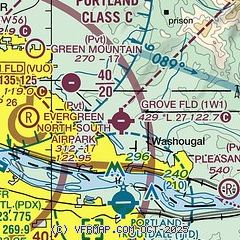
|
| Airport distance calculator |
|---|
|
|
| Sunrise and sunset |
|---|
|
Times for 13-Apr-2026
| | Local
(UTC-7) | | Zulu
(UTC) |
|---|
| Morning civil twilight | | 05:57 | | 12:57 |
| Sunrise | | 06:28 | | 13:28 |
| Sunset | | 19:52 | | 02:52 |
| Evening civil twilight | | 20:23 | | 03:23 |
|
| Current date and time |
|---|
| Zulu (UTC) | 13-Apr-2026 17:36:45 |
|---|
| Local (UTC-7) | 13-Apr-2026 10:36:45 |
|---|
|
| METAR |
|---|
KTTD
5nm S | 131653Z 00000KT 10SM -RA FEW012 BKN036 OVC047 09/08 A3011 RMK AO2 RAB1557E11B36 SLP196 P0000 T00940078
|
KPDX
9nm W | 131653Z 32004KT 10SM FEW012 SCT028 OVC060 10/07 A3011 RMK AO2 SLP196 T01000072
|
KVUO
10nm W | 131653Z AUTO 28004KT 10SM SCT014 SCT026 OVC060 11/07 A3013 RMK AO2 RAB22E42 SLP201 P0000 T01060072
|
|
| TAF |
|---|
KTTD
5nm S | 131138Z 1312/1412 VRB05KT P6SM VCSH SCT009 BKN025 OVC040 TEMPO 1312/1315 2SM -RA BR BKN009 OVC025 FM132100 VRB05KT P6SM -SHRA SCT025 OVC050 FM140400 VRB03KT P6SM OVC050
|
KPDX
9nm W | 131505Z 1315/1412 29005KT 6SM -SHRA SCT015 BKN022 OVC040 FM132100 28006KT P6SM VCSH SCT025 BKN035 OVC050 FM140600 24004KT P6SM FEW035 OVC050
|
|
| NOTAMs |
|---|
NOTAMs are issued by the DoD/FAA and will open in a separate window not controlled by AirNav.
|
|

