FAA INFORMATION EFFECTIVE 23 JANUARY 2025
Location
| FAA Identifier: | 1G3 |
| Lat/Long: | 41-09-05.0000N 081-24-54.4000W
41-09.083333N 081-24.906667W
41.1513889,-81.4151111
(estimated) |
| Elevation: | 1134.4 ft. / 345.8 m (surveyed) |
| Variation: | 07W (1990) |
| From city: | 3 miles W of KENT, OH |
| Time zone: | UTC -5 (UTC -4 during Daylight Saving Time) |
| Zip code: | 44224 |
Airport Operations
| Airport use: | Open to the public |
| Activation date: | 01/1938 |
| Control tower: | no |
| ARTCC: | CLEVELAND CENTER |
| FSS: | CLEVELAND FLIGHT SERVICE STATION |
| NOTAMs facility: | CLE (NOTAM-D service available) |
| Attendance: | MON-FRI 0630-DUSK, ALL SAT-SUN 0800-DUSK
CLSD DEC 25 & JAN 1. |
| Pattern altitude: | 1984.4 ft. MSL |
| Wind indicator: | lighted |
| Segmented circle: | no |
| Lights: | ACTVT REIL RWY 01 & 19; VASI RWY 01 & 19; MIRL RWY 01/19 - 122.9. |
| Beacon: | white-green (lighted land airport)
Operates sunset to sunrise. |
| Landing fee: | no, RAMP FEE FOR MULTI-ENG ACFT - WAIVED WITH FUEL PURCHASE. |
Airport Communications
| CTAF/UNICOM: | 122.725 |
| WX AWOS-2: | 119.15 (330-346-1497) |
| CLEVELAND APPROACH: | 125.5 |
| CLEVELAND DEPARTURE: | 125.5 |
| CLEARANCE DELIVERY: | 125.65 |
| BRWNZ STAR: | 126.55 |
| WX ASOS at AKR (7 nm S): | 126.825 (330-724-4237) |
| WX AWOS-3 at POV (8 nm NE): | 118.675 (330-298-9353) |
| WX ASOS at CAK (14 nm S): | PHONE 216-273-5266 |
- APCH/DEP SVC PRVDD BY CLEVELAND APCH (CLE) 0600-0100. APCH/DEP SVC PRVDD BY CLEVELAND ARTCC (ZOB) ON FREQS 120.6/379.275 (MOUNT HOPE RCAG) 0100-0600.
Nearby radio navigation aids
| VOR radial/distance | | VOR name | | Freq | | Var |
|---|
| ACOr289/10.0 | | AKRON VOR/DME | | 114.40 | | 04W |
| BSVr006/24.7 | | BRIGGS VOR/DME | | 114.05 | | 04W |
| CXRr212/24.7 | | CHARDON VOR/DME | | 112.70 | | 05W |
| DJBr115/35.9 | | DRYER VOR/DME | | 113.60 | | 05W |
| NDB name | | Hdg/Dist | | Freq | | Var | | ID |
|---|
| AKRON | | 353/5.1 | | 362 | | 07W | | AK | .- -.- |
Airport Services
| Fuel available: | 100LL
100LL:AVBL ONLY WHEN ATNDD, SELF SER UNAVBL. |
| Parking: | hangars and tiedowns |
| Airframe service: | NONE |
| Powerplant service: | NONE |
Runway Information
Runway 1/19
| Dimensions: | 4000 x 60 ft. / 1219 x 18 m |
| Surface: | asphalt, in fair condition |
| Runway edge lights: | medium intensity |
| RUNWAY 1 | | RUNWAY 19 |
| Latitude: | 41-08.757023N | | 41-09.408328N |
| Longitude: | 081-24.972128W | | 081-24.842207W |
| Elevation: | 1116.4 ft. | | 1134.0 ft. |
| Traffic pattern: | left | | left |
| Runway heading: | 016 magnetic, 009 true | | 196 magnetic, 189 true |
| Displaced threshold: | 53 ft. | | no |
| Markings: | nonprecision, in fair condition | | nonprecision, in fair condition |
| Visual slope indicator: | 4-box VASI on left (3.50 degrees glide path) | | 4-box VASI on left (3.00 degrees glide path) |
| Runway end identifier lights: | yes | | yes |
| Touchdown point: | yes, no lights | | yes, no lights |
| Obstructions: | 122 ft. trees, 1993 ft. from runway, 364 ft. left of centerline, 14:1 slope to clear
APCH RATIO 16:1 TO DTHR DUE TO +122 FT TREE, 1993 FT DIST, 364 FT L. | | 88 ft. trees, 1586 ft. from runway, 239 ft. right of centerline, 15:1 slope to clear |
Airport Ownership and Management from official FAA records
| Ownership: | Publicly-owned |
| Owner: | KENT STATE UNIVERSITY
4020 KENT RD
STOW, OH 44224-4200
Phone 330-672-2640
ADNL INFO: WWW.KENT.EDU/AIRPORT. |
| Manager: | DAVID POLUGA
4020 KENT RD
STOW, OH 44224-4200
Phone 330-672-1943 |
Additional Remarks
| A30A-19 | CALM WIND RWY. |
| - | OCNL DEER, BIRDS & OTR WILDLIFE ON & INVOF ARPT. |
| - | FOR NOISE ABATEMENT PROCS CALL AMGR. |
| - | FOR CD CTC CLEVELAND ARTCC AT 440-774-0223. |
| - | HVY STUDENT TRG ACT. |
Instrument Procedures
NOTE: All procedures below are presented as PDF files. If you need a reader for these files, you should download the free Adobe Reader.NOT FOR NAVIGATION. Please procure official charts for flight.
FAA instrument procedures published for use from 23 January 2025 at 0901Z to 20 February 2025 at 0900z.
STARs - Standard Terminal Arrivals |
|---|
| BRWNZ FOUR (RNAV) | |
2 pages:
[1] [2] (447KB) |
| BRWNZ FOUR (RNAV), CONT.2 | |
download (234KB) |
| HUUVR ONE (RNAV) | |
download (168KB) |
| ZZIPS ONE (RNAV) | |
download (149KB) |
IAPs - Instrument Approach Procedures |
|---|
| RNAV (GPS) RWY 01 | |
download (201KB) |
| RNAV (GPS) RWY 19 | |
download (184KB) |
| VOR-A | |
download (183KB) |
| NDB RWY 01 | |
download (186KB) |
| NOTE: Special Take-Off Minimums/Departure Procedures apply | |
download (460KB) |
Other nearby airports with instrument procedures:
KAKR - Akron Fulton International Airport (7 nm S)
KPOV - Portage County Airport (8 nm NE)
KCAK - Akron-Canton Regional Airport (14 nm S)
1G5 - Medina Municipal Airport (16 nm W)
3G3 - Wadsworth Municipal Airport (18 nm SW)
|
|

Road maps at:
MapQuest
Bing
Google
| Aerial photo |
|---|
WARNING: Photo may not be current or correct
 Photo taken 30-Sep-2005
taken from the North at 2500 ft AGL
Photo taken 30-Sep-2005
taken from the North at 2500 ft AGL
Do you have a better or more recent aerial photo of Kent State University Airport that you would like to share? If so, please send us your photo.
|
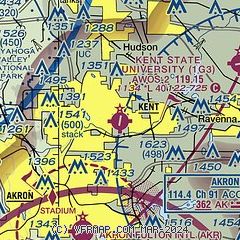
| Sectional chart |
|---|
|
| Airport distance calculator |
|---|
|
|
| Sunrise and sunset |
|---|
|
Times for 16-Feb-2025
| | Local
(UTC-5) | | Zulu
(UTC) |
|---|
| Morning civil twilight | | 06:52 | | 11:52 |
| Sunrise | | 07:20 | | 12:20 |
| Sunset | | 18:00 | | 23:00 |
| Evening civil twilight | | 18:28 | | 23:28 |
|
| Current date and time |
|---|
| Zulu (UTC) | 16-Feb-2025 19:09:08 |
|---|
| Local (UTC-5) | 16-Feb-2025 14:09:08 |
|---|
|
| METAR |
|---|
KAKR
7nm S | 160654Z AUTO 06004KT 4SM -RA BR OVC046 03/02 A2955 RMK AO2 PRESFR SLP014 P0015 T00280022
|
KPOV
8nm NE | 161855Z AUTO 30016G24KT 1SM OVC010 M03/M05 A2941 RMK AO2 T10351046 PWINO
|
KCAK
14nm S | 161851Z 30016G29KT 1/2SM R23/P6000FT -SN BLSN BKN010 OVC018 M03/M04 A2943 RMK AO2 PK WND 31036/1821 SFC VIS 3/4 SLP977 P0001 T10281044 $
|
|
| TAF |
|---|
KCAK
14nm S | 161742Z 1618/1718 30018G29KT 1/2SM SN OVC006 FM162000 30015G25KT 5SM BR VCSH OVC008 FM162300 29016G24KT 1 1/2SM -SHSN BR OVC015 FM170600 29014KT 5SM BR VCSH BKN014 FM171500 27013G23KT P6SM OVC025
|
|
| NOTAMs |
|---|
NOTAMs are issued by the DoD/FAA and will open in a separate window not controlled by AirNav.
|
|


