FAA INFORMATION EFFECTIVE 19 FEBRUARY 2026
Location
| FAA Identifier: | 2J3 |
| Lat/Long: | 32-59-09.4000N 082-23-05.3000W
32-59.156667N 082-23.088333W
32.9859444,-82.3848056
(estimated) |
| Elevation: | 327.9 ft. / 99.9 m (surveyed) |
| Variation: | 03W (1985) |
| From city: | 2 miles SE of LOUISVILLE, GA |
| Time zone: | UTC -5 (UTC -4 during Daylight Saving Time) |
| Zip code: | 30434 |
Airport Operations
| Airport use: | Open to the public |
| Control tower: | no |
| ARTCC: | ATLANTA CENTER |
| FSS: | MACON FLIGHT SERVICE STATION |
| NOTAMs facility: | MCN (NOTAM-D service available) |
| Attendance: | UNATNDD |
| Wind indicator: | lighted |
| Segmented circle: | yes |
| Lights: | ACTVT PAPI RWY 13 & 31; MIRL RWY 13/31- CTAF. |
| Beacon: | white-green (lighted land airport)
Operates sunset to sunrise. |
Airport Communications
| CTAF: | 122.9 |
| WX AWOS-3PT: | 119.35 (478-625-8303) |
| AUGUSTA APPROACH: | 126.8 |
| AUGUSTA DEPARTURE: | 126.8 |
Nearby radio navigation aids
| VOR radial/distance | | VOR name | | Freq | | Var |
|---|
| DBNr047/33.9 | | DUBLIN VORTAC | | 113.10 | | 05W |
| NDB name | | Hdg/Dist | | Freq | | Var | | ID |
|---|
| EMORY | | 218/34.6 | | 385 | | 04W | | EMR | . -- .-. |
Airport Services
| Fuel available: | 100LL JET-A+ |
| Parking: | tiedowns |
| Airframe service: | MAJOR |
| Powerplant service: | MAJOR |
| Bottled oxygen: | NONE |
| Bulk oxygen: | NONE |
Runway Information
Runway 13/31
| Dimensions: | 5002 x 100 ft. / 1525 x 30 m |
| Surface: | asphalt, in fair condition |
| Weight bearing capacity: | |
| Runway edge lights: | medium intensity |
| RUNWAY 13 | | RUNWAY 31 |
| Latitude: | 32-59.384502N | | 32-58.927245N |
| Longitude: | 082-23.495093W | | 082-22.680707W |
| Elevation: | 327.9 ft. | | 293.6 ft. |
| Traffic pattern: | left | | left |
| Runway heading: | 127 magnetic, 124 true | | 307 magnetic, 304 true |
| Markings: | nonprecision, in good condition | | nonprecision, in good condition |
| Visual slope indicator: | 2-light PAPI on left (3.83 degrees glide path) | | 2-light PAPI on left (3.65 degrees glide path) |
| Runway end identifier lights: | no | | no |
| Touchdown point: | yes, no lights | | yes, no lights |
| Obstructions: | 55 ft. trees, 835 ft. from runway, 343 ft. right of centerline, 11:1 slope to clear | | 20 ft. trees, 671 ft. from runway, 184 ft. left of centerline, 23:1 slope to clear |
Airport Ownership and Management from official FAA records
| Ownership: | Publicly-owned |
| Owner: | CITY OF LOUISVILLE
CITY HALL, PO BOX 527
LOUISVILLE, GA 30434
Phone 478-625-3166 |
| Manager: | RICHARD SAPP
PO BOX 527
LOUISVILLE, GA 30434
Phone 478-625-3166 |
Additional Remarks
| - | FOR CD CTC AUGUSTA APCH AT 706-771-1777, WHEN APCH CLSD CTC ATLANTA ARTCC AT 770-210-7692.. |
| - | CALL AMGR - 478-625-3166 - FOR COURTESY CAR |
Instrument Procedures
NOTE: All procedures below are presented as PDF files. If you need a reader for these files, you should download the free Adobe Reader.NOT FOR NAVIGATION. Please procure official charts for flight.
FAA instrument procedures published for use from 19 February 2026 at 0901Z to 19 March 2026 at 0900Z.
IAPs - Instrument Approach Procedures |
|---|
| RNAV (GPS) RWY 13 **CHANGED** | |
download (207KB) |
| RNAV (GPS) RWY 31 **CHANGED** | |
download (202KB) |
| NOTE: Special Alternate Minimums apply | |
download (158KB) |
| NOTE: Special Take-Off Minimums/Departure Procedures apply | |
download (665KB) |
Other nearby airports with instrument procedures:
KBXG - Burke County Airport (19 nm E)
2J5 - Millen Airport (22 nm E)
KSBO - East Georgia Regional Airport (23 nm S)
KOKZ - Kaolin Field Airport (23 nm W)
KAGS - Augusta Regional Airport at Bush Field (31 nm NE)
|
|

Road maps at:
MapQuest
Bing
Google
| Aerial photo |
|---|
WARNING: Photo may not be current or correct

Do you have a better or more recent aerial photo of Louisville Municipal Airport that you would like to share? If so, please send us your photo.
|
| Sectional chart |
|---|
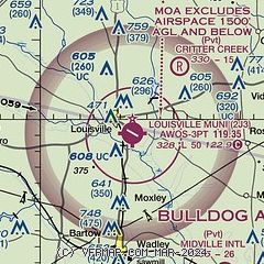
|
| Airport distance calculator |
|---|
|
|
| Sunrise and sunset |
|---|
|
Times for 17-Mar-2026
| | Local
(UTC-4) | | Zulu
(UTC) |
|---|
| Morning civil twilight | | 07:14 | | 11:14 |
| Sunrise | | 07:38 | | 11:38 |
| Sunset | | 19:38 | | 23:38 |
| Evening civil twilight | | 20:02 | | 00:02 |
|
| Current date and time |
|---|
| Zulu (UTC) | 18-Mar-2026 02:44:24 |
|---|
| Local (UTC-4) | 17-Mar-2026 22:44:24 |
|---|
|
| TAF |
|---|
KAGS
31nm NE | 171720Z 1718/1818 28013G22KT P6SM SKC TEMPO 1718/1720 23010G19KT FM180000 31004KT P6SM FEW250 FM181400 06004KT P6SM SCT250
|
KDNL
34nm NE | 171720Z 1718/1818 28013G22KT P6SM SKC FM180000 31004KT P6SM FEW250 FM181300 06005KT P6SM SCT250
|
|
| NOTAMs |
|---|
NOTAMs are issued by the DoD/FAA and will open in a separate window not controlled by AirNav.
|
|


