FAA INFORMATION EFFECTIVE 11 JUNE 2026
Location
| FAA Identifier: | 2J5 |
| Lat/Long: | 32-53-34.9000N 081-57-54.8000W
32-53.581667N 081-57.913333W
32.8930278,-81.9652222
(estimated) |
| Elevation: | 240.4 ft. / 73.3 m (surveyed) |
| Variation: | 05W (2000) |
| From city: | 5 miles N of MILLEN, GA |
| Time zone: | UTC -4 (UTC -5 during Standard Time) |
| Zip code: | 30822 |
Airport Operations
| Airport use: | Open to the public |
| Activation date: | 08/1967 |
| Control tower: | no |
| ARTCC: | ATLANTA CENTER |
| FSS: | MACON FLIGHT SERVICE STATION |
| NOTAMs facility: | MCN (NOTAM-D service available) |
| Attendance: | UNATNDD |
| Wind indicator: | lighted |
| Segmented circle: | yes |
| Lights: | DUSK-2200. MIRL, REIL AND PAPI RY 17/35 OPERATES DUSK-2200; AFTER 2200 ACTVT - CTAF. |
| Beacon: | white-green (lighted land airport)
Operates sunset to sunrise. |
Airport Communications
| CTAF: | 122.9 |
| WX AWOS-3PT: | 120.2 (478-982-4562) |
| AUGUSTA APPROACH: | 126.8 |
| AUGUSTA DEPARTURE: | 126.8 |
Nearby radio navigation aids
| VOR radial/distance | | VOR name | | Freq | | Var |
|---|
| ALDr259/(34.6) | | ALLENDALE VOR | | 116.70 | | 01W |
| NDB name | | Hdg/Dist | | Freq | | Var | | ID |
|---|
| BULLO | | 337/32.4 | | 407 | | 05W | | BZQ | -... --.. --.- |
| EMORY | | 181/34.2 | | 385 | | 04W | | EMR | . -- .-. |
Airport Services
| Fuel available: | 100LL JET-A+ |
| Parking: | tiedowns |
| Airframe service: | NONE |
| Powerplant service: | NONE |
| Bottled oxygen: | NONE |
| Bulk oxygen: | NONE |
Runway Information
Runway 17/35
| Dimensions: | 5001 x 75 ft. / 1524 x 23 m |
| Surface: | asphalt, in good condition |
| Weight bearing capacity: | |
| Runway edge lights: | medium intensity |
| RUNWAY 17 | | RUNWAY 35 |
| Latitude: | 32-53.983643N | | 32-53.178385N |
| Longitude: | 081-58.018257W | | 081-57.807823W |
| Elevation: | 240.3 ft. | | 221.2 ft. |
| Traffic pattern: | right | | left |
| Runway heading: | 173 magnetic, 168 true | | 353 magnetic, 348 true |
| Markings: | nonprecision, in fair condition | | nonprecision, in fair condition |
| Visual slope indicator: | 2-light PAPI on right (3.00 degrees glide path) | | 2-light PAPI on left (3.00 degrees glide path) |
| Runway end identifier lights: | yes | | yes |
| Touchdown point: | yes, no lights | | yes, no lights |
| Obstructions: | 51 ft. pole, 710 ft. from runway, 323 ft. right of centerline, 10:1 slope to clear | | 46 ft. trees, 982 ft. from runway, 31 ft. right of centerline, 17:1 slope to clear |
Airport Ownership and Management from official FAA records
| Ownership: | Publicly-owned |
| Owner: | JENKINS CO
PO BOX 797
MILLEN, GA 30442
Phone 478-982-2563 |
| Manager: | GRADY SAXON
PO BOX 797
MILLEN, GA 30442
Phone (478)982-2563 |
Additional Remarks
| - | DEER ON & INVOF ARPT. |
| - | FOR CD CTC ATLANTA ARTCC AT 770-210-7692. |
Instrument Procedures
NOTE: All procedures below are presented as PDF files. If you need a reader for these files, you should download the free Adobe Reader.NOT FOR NAVIGATION. Please procure official charts for flight.
FAA instrument procedures published for use from 11 June 2026 at 0901Z to 09 July 2026 at 0900z.
IAPs - Instrument Approach Procedures |
|---|
| RNAV (GPS) RWY 17 | |
download (216KB) |
| RNAV (GPS) RWY 35 | |
download (229KB) |
| NOTE: Special Alternate Minimums apply | |
download (68KB) |
| NOTE: Special Take-Off Minimums/Departure Procedures apply | |
download (518KB) |
Other nearby airports with instrument procedures:
KBXG - Burke County Airport (9 nm N)
2J3 - Louisville Municipal Airport (22 nm W)
KJYL - Plantation Airpark (24 nm SE)
KSBO - East Georgia Regional Airport (27 nm SW)
KTBR - Statesboro-Bulloch County Airport (27 nm SE)
|
|

Road maps at:
MapQuest
Bing
Google
| Aerial photo |
|---|
WARNING: Photo may not be current or correct
 Photo taken 27-Sep-2016
looking north.
Photo taken 27-Sep-2016
looking north.
Do you have a better or more recent aerial photo of Millen Airport that you would like to share? If so, please send us your photo.
|
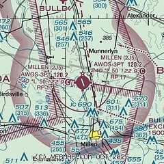
| Sectional chart |
|---|
|
| Airport distance calculator |
|---|
|
|
| Sunrise and sunset |
|---|
|
Times for 20-Jun-2026
| | Local
(UTC-4) | | Zulu
(UTC) |
|---|
| Morning civil twilight | | 05:52 | | 09:52 |
| Sunrise | | 06:21 | | 10:21 |
| Sunset | | 20:38 | | 00:38 |
| Evening civil twilight | | 21:07 | | 01:07 |
|
| Current date and time |
|---|
| Zulu (UTC) | 20-Jun-2026 17:13:13 |
|---|
| Local (UTC-4) | 20-Jun-2026 13:13:13 |
|---|
|
| METAR |
|---|
| K2J5 | 201635Z AUTO 00000KT 10SM CLR 29/19 A3001 RMK AO2 T02950193
|
|
| TAF |
|---|
KAGS
28nm N | 201431Z 2015/2112 08008KT P6SM SCT250 FM210000 00000KT P6SM BKN250
|
KDNL
35nm N | 201431Z 2015/2112 08008KT P6SM SCT250 FM210000 VRB03KT P6SM BKN250
|
|
| NOTAMs |
|---|
NOTAMs are issued by the DoD/FAA and will open in a separate window not controlled by AirNav.
|
|


