FAA INFORMATION EFFECTIVE 09 JULY 2026
Location
| FAA Identifier: | 2K7 |
| Lat/Long: | 37-26-07.3120N 095-38-46.0280W
37-26.121867N 095-38.767133W
37.4353644,-95.6461189
(estimated) |
| Elevation: | 841 ft. / 256.3 m (surveyed) |
| Variation: | 02E (2020) |
| From city: | 2 miles NE of NEODESHA, KS |
| Time zone: | UTC -5 (UTC -6 during Standard Time) |
| Zip code: | 66757 |
Airport Operations
| Airport use: | Open to the public |
| Activation date: | 08/1949 |
| Control tower: | no |
| ARTCC: | KANSAS CITY CENTER |
| FSS: | WICHITA FLIGHT SERVICE STATION |
| NOTAMs facility: | ICT (NOTAM-D service available) |
| Attendance: | UNATNDD |
| Wind indicator: | yes |
| Segmented circle: | yes |
| Lights: | SS-SR |
| Beacon: | white-green (lighted land airport)
Operates sunset to sunrise. |
Airport Communications
| CTAF/UNICOM: | 122.8 |
| WX ASOS at PPF (9 nm SE): | 118.175 (620-336-3834) |
| WX ASOS at CNU (16 nm NE): | 127.075 (620-431-6781) |
| WX AWOS-3PT at IDP (18 nm S): | 118.525 (620-331-5980) |
- APCH/DEP CTL SVC PRVDD BY KANSAS CITY ARTCC (ZKC) ON FREQS 132.9/279.5 (CHANUTE RCAG).
Airport Services
| Fuel available: | MOGAS |
| Parking: | tiedowns |
| Airframe service: | NONE |
| Powerplant service: | NONE |
| Bottled oxygen: | NONE |
| Bulk oxygen: | NONE |
Runway Information
Runway 2/20
| Dimensions: | 2998 x 46 ft. / 914 x 14 m |
| Surface: | asphalt, in poor condition
MEDIUM/HIGH SEVERITY TRANSVERSE CRACKING LENGTH OF RWY 02/20. |
| Weight bearing capacity: | |
| Runway edge lights: | low intensity
NSTD LIRL; ALL CLEAR LENSES. |
| RUNWAY 2 | | RUNWAY 20 |
| Latitude: | 37-25.865767N | | 37-26.299083N |
| Longitude: | 095-38.982900W | | 095-38.685417W |
| Elevation: | 822.0 ft. | | 841.0 ft. |
| Traffic pattern: | left | | left |
| Runway heading: | 027 magnetic, 029 true | | 207 magnetic, 209 true |
| Markings: | basic, in fair condition | | basic, in fair condition |
| Runway end identifier lights: | no | | no |
| Touchdown point: | yes, no lights | | yes, no lights |
| Obstructions: | 68 ft. trees, 823 ft. from runway, 106 ft. right of centerline, 9:1 slope to clear | | none
+ 5 FT FENCE POST 190 FT FM RWY 20; 96 FT RIGHT OF CL |
Runway 15/33
| Dimensions: | 2100 x 45 ft. / 640 x 14 m |
| Surface: | turf, in good condition |
| Runway edge markings: | WHITE BARREL MARKERS ON BOTH ENDS. |
| RUNWAY 15 | | RUNWAY 33 |
| Latitude: | 37-26.336850N | | 37-26.020200N |
| Longitude: | 095-38.757150W | | 095-38.582133W |
| Elevation: | 840.0 ft. | | 825.0 ft. |
| Traffic pattern: | left | | left |
| Runway heading: | 154 magnetic, 156 true | | 334 magnetic, 336 true |
| Markings: | , in fair condition | | , in fair condition |
| Obstructions: | none | | 35 ft. tree, 440 ft. from runway, 12 ft. left of centerline, 12:1 slope to clear |
Airport Ownership and Management from official FAA records
| Ownership: | Publicly-owned |
| Owner: | CITY OF NEODESHA
PO BOX 336
NEODESHA, KS 66757
Phone 620-325-2828 |
| Manager: | JEREMY JOHNSON
PO BOX 336
NEODESHA, KS 66757
Phone 620-288-9264
EVENING CALL 620-920-0348 |
Additional Remarks
| - | ULTRALIGHT ACTIVITY ON AND INVOF ARPT. |
| - | WILDLIFE ON & INVOF ARPT. |
| - | FOR CD CTC KANSAS CITY ARTCC AT 913-254-8508. |
Instrument Procedures
NOTE: All procedures below are presented as PDF files. If you need a reader for these files, you should download the free Adobe Reader.NOT FOR NAVIGATION. Please procure official charts for flight.
FAA instrument procedures published for use from 09 July 2026 at 0901Z to 06 August 2026 at 0900Z.
IAPs - Instrument Approach Procedures |
|---|
| RNAV (GPS)-A | |
download (163KB) |
| NOTE: Special Take-Off Minimums/Departure Procedures apply | |
download (352KB) |
Other nearby airports with instrument procedures:
KPPF - Tri-City Airport (9 nm SE)
KCNU - Chanute Martin Johnson Airport (16 nm NE)
KIDP - Independence Municipal Airport (18 nm S)
KCFV - Coffeyville Municipal Airport (21 nm S)
K88 - Allen County Airport (29 nm NE)
|
|

Road maps at:
MapQuest
Bing
Google
| Aerial photo |
|---|
WARNING: Photo may not be current or correct
 Photo by David Heon
Photo taken 21-May-2017
looking northwest.
Photo by David Heon
Photo taken 21-May-2017
looking northwest.
Do you have a better or more recent aerial photo of Neodesha Municipal Airport that you would like to share? If so, please send us your photo.
|
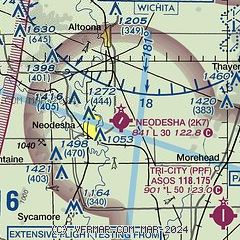
| Sectional chart |
|---|
|
| Airport distance calculator |
|---|
|
|
| Sunrise and sunset |
|---|
|
Times for 26-Jul-2026
| | Local
(UTC-5) | | Zulu
(UTC) |
|---|
| Morning civil twilight | | 05:53 | | 10:53 |
| Sunrise | | 06:23 | | 11:23 |
| Sunset | | 20:35 | | 01:35 |
| Evening civil twilight | | 21:05 | | 02:05 |
|
| Current date and time |
|---|
| Zulu (UTC) | 26-Jul-2026 07:43:00 |
|---|
| Local (UTC-5) | 26-Jul-2026 02:43:00 |
|---|
|
| METAR |
|---|
KPPF
9nm SE | 260652Z AUTO 17003KT 10SM CLR 27/24 A2997 RMK AO2 SLP135 T02720244
|
KCNU
16nm NE | 260652Z AUTO 18005KT 10SM CLR 28/24 A2997 RMK AO2 SLP135 T02780244 $
|
KIDP
18nm S | 260710Z AUTO 19006KT 10SM CLR 28/24 A2996 RMK AO2
|
|
| TAF |
|---|
KCNU
16nm NE | 260520Z 2606/2706 18005KT P6SM SKC FM261500 20008KT P6SM FEW050 FM270100 17008KT P6SM SKC
|
|
| NOTAMs |
|---|
NOTAMs are issued by the DoD/FAA and will open in a separate window not controlled by AirNav.
|
|


