FAA INFORMATION EFFECTIVE 25 DECEMBER 2025
Location
| FAA Identifier: | 3G4 |
| Lat/Long: | 40-54-10.7000N 082-15-20.3000W
40-54.178333N 082-15.338333W
40.9029722,-82.2556389
(estimated) |
| Elevation: | 1206.7 ft. / 367.8 m (surveyed) |
| Variation: | 07W (1995) |
| From city: | 3 miles NE of ASHLAND, OH |
| Time zone: | UTC -5 (UTC -4 during Daylight Saving Time) |
| Zip code: | 44805 |
Airport Operations
| Airport use: | Open to the public |
| Control tower: | no |
| ARTCC: | CLEVELAND CENTER |
| FSS: | CLEVELAND FLIGHT SERVICE STATION |
| NOTAMs facility: | CLE (NOTAM-D service available) |
| Attendance: | 0800-1800 |
| Wind indicator: | lighted |
| Segmented circle: | no |
| Lights: | ACTVT REIL RWY 01 & 19; PAPI RWY 01; VASI RWY 19; MIRL RWY 01/19 - CTAF. |
| Beacon: | white-green (lighted land airport)
Operates sunset to sunrise. |
Airport Communications
| CTAF/UNICOM: | 122.7 |
| CLEVELAND APPROACH: | 128.35 |
| CLEVELAND DEPARTURE: | 128.35 |
| WX ASOS at MFD (13 nm W): | 125.3 (419-520-7277) |
| WX ASOS at BJJ (17 nm E): | 118.075 (330-669-9105) |
- APCH/DEP SVC PRVDD BY CLEVELAND APCH (CLE) 0600-0100. APCH/DEP SVC PRVDD BY CLEVELAND ARTCC (ZOB) ON FREQS 134.9/269.475 (MANSFIELD RCAG) 0100-0600.
Nearby radio navigation aids
| VOR radial/distance | | VOR name | | Freq | | Var |
|---|
| DJBr194/27.6 | | DRYER VOR/DME | | 113.60 | | 05W |
| BSVr289/38.6 | | BRIGGS VOR/DME | | 114.05 | | 04W |
| NDB name | | Hdg/Dist | | Freq | | Var | | ID |
|---|
| MANNS | | 052/11.9 | | 372 | | 06W | | MF | -- ..-. |
Airport Services
| Fuel available: | 100LL JET-A+
100LL:100LL & JET A AVBL AFT HRS - CALL AMGR CELL. |
| Parking: | hangars and tiedowns |
| Airframe service: | MINOR |
| Powerplant service: | MINOR |
Runway Information
Runway 1/19
| Dimensions: | 3501 x 75 ft. / 1067 x 23 m |
| Surface: | asphalt, in fair condition |
| Runway edge lights: | medium intensity |
| RUNWAY 1 | | RUNWAY 19 |
| Latitude: | 40-53.890648N | | 40-54.467062N |
| Longitude: | 082-15.343352W | | 082-15.333157W |
| Elevation: | 1206.0 ft. | | 1186.8 ft. |
| Traffic pattern: | right | | left |
| Runway heading: | 008 magnetic, 001 true | | 188 magnetic, 181 true |
| Markings: | nonprecision, in fair condition | | nonprecision, in fair condition |
| Visual slope indicator: | 4-light PAPI on left (3.00 degrees glide path) | | 2-box VASI on left (3.00 degrees glide path) |
| Runway end identifier lights: | yes | | yes |
| Touchdown point: | yes, no lights | | yes, no lights |
| Obstructions: | 87 ft. trees, 1661 ft. from runway, 181 ft. left of centerline, 16:1 slope to clear | | 69 ft. trees, 285 ft. from runway, 239 ft. right of centerline, 1:1 slope to clear |
Airport Ownership and Management from official FAA records
| Ownership: | Publicly-owned |
| Owner: | ASHLAND CO ARPT AUTH
700 TOWNSHIP ROAD 1102
ASHLAND, OH 44805-8935
Phone 419-281-3966 |
| Manager: | DENNIS BAUM
700 TOWNSHIP ROAD 1102
ASHLAND, OH 44805-8935
Phone 419-281-3966
CELL 419-685-1875. |
Additional Remarks
| - | OCNL DEER ON & INVOF ARPT. |
| - | FOR CD CTC CLEVELAND APCH AT 216-352-2323, WHEN APCH CLSD CTC CLEVELAND ARTCC AT 440-774-0223/0490. |
| - | EXTSV PAJA; LDG ZONE LCTD AT SW CORNER OF ARPT PROPERTY. |
Instrument Procedures
NOTE: All procedures below are presented as PDF files. If you need a reader for these files, you should download the free Adobe Reader.NOT FOR NAVIGATION. Please procure official charts for flight.
FAA instrument procedures published for use from 25 December 2025 at 0901z to 22 January 2026 at 0900z.
IAPs - Instrument Approach Procedures |
|---|
| RNAV (GPS) RWY 19 | |
download (211KB) |
| NOTE: Special Take-Off Minimums/Departure Procedures apply | |
download (164KB) |
Other nearby airports with instrument procedures:
KMFD - Mansfield Lahm Regional Airport (13 nm W)
KBJJ - Wayne County Airport (17 nm E)
12G - Shelby Community Airport (20 nm W)
8G1 - Willard Airport (23 nm W)
KGQQ - Galion Municipal Airport (23 nm SW)
|
|

Road maps at:
MapQuest
Bing
Google
| Aerial photo |
|---|
WARNING: Photo may not be current or correct
 Photo by Joe Kessler
Photo taken 18-Oct-2005
Photo by Joe Kessler
Photo taken 18-Oct-2005
Do you have a better or more recent aerial photo of Ashland County Airport that you would like to share? If so, please send us your photo.
|
| Sectional chart |
|---|
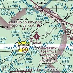
|
| Airport distance calculator |
|---|
|
|
| Sunrise and sunset |
|---|
|
Times for 30-Dec-2025
| | Local
(UTC-5) | | Zulu
(UTC) |
|---|
| Morning civil twilight | | 07:23 | | 12:23 |
| Sunrise | | 07:54 | | 12:54 |
| Sunset | | 17:09 | | 22:09 |
| Evening civil twilight | | 17:40 | | 22:40 |
|
| Current date and time |
|---|
| Zulu (UTC) | 30-Dec-2025 16:02:18 |
|---|
| Local (UTC-5) | 30-Dec-2025 11:02:18 |
|---|
|
| METAR |
|---|
KMFD
13nm SW | 301552Z 25011G21KT 2SM R32/6000VP6000FT -SN BR OVC013 M08/M10 A3003 RMK AO2 SLP189 P0001 T10781100 $
|
KBJJ
17nm E | 301556Z AUTO 28013G25KT 2 1/2SM -SN SCT017 BKN021 OVC037 M06/M09 A3002 RMK AO2 SLP183 P0000 T10611094
|
|
| TAF |
|---|
KMFD
13nm SW | 301134Z 3012/3112 28012G20KT 5SM -SHSN OVC015 FM310100 22011KT 4SM -SHSN OVC015 FM310400 24012KT 2SM -SHSN OVC015 FM310800 24012KT 4SM -SHSN OVC015
|
|
| NOTAMs |
|---|
NOTAMs are issued by the DoD/FAA and will open in a separate window not controlled by AirNav.
|
|


