FAA INFORMATION EFFECTIVE 27 NOVEMBER 2025
Location
| FAA Identifier: | 3I3 |
| Lat/Long: | 39-32-52.0320N 087-22-38.4690W
39-32.867200N 087-22.641150W
39.5477867,-87.3773525
(estimated) |
| Elevation: | 496 ft. / 151.2 m (surveyed) |
| Variation: | 04W (2020) |
| From city: | 5 miles N of TERRE HAUTE, IN |
| Time zone: | UTC -5 (UTC -4 during Daylight Saving Time) |
| Zip code: | 47805 |
Airport Operations
| Airport use: | Open to the public |
| Activation date: | 04/1962 |
| Control tower: | no |
| ARTCC: | INDIANAPOLIS CENTER |
| FSS: | TERRE HAUTE FLIGHT SERVICE STATION |
| NOTAMs facility: | HUF (NOTAM-D service available) |
| Attendance: | 0700-DUSK |
| Wind indicator: | yes |
| Segmented circle: | no |
| Lights: | ACTVT LIRL RWY 09/27 & 18/36 - CTAF. |
| Beacon: | white-green (lighted land airport)
ACTVT ROTG BCN - CTAF. |
Airport Communications
| CTAF/UNICOM: | 122.8 |
| HULMAN APPROACH: | 125.45 134.725 [0530-0000 SUN-FRI, 0530-2345 SAT.] |
| HULMAN DEPARTURE: | 125.45 134.725 [0530-0000 SUN-FRI, 0530-2345 SAT.] |
| WX ASOS at HUF (7 nm SE): | 127.5 (812-877-7010) |
| WX AWOS-3 at PRG (16 nm NW): | 124.175 (217-465-4304) |
Nearby radio navigation aids
| VOR radial/distance | | VOR name | | Freq | | Var |
|---|
| TTHr299/6.9 | | TERRE HAUTE VORTAC | | 115.30 | | 02E |
| NDB name | | Hdg/Dist | | Freq | | Var | | ID |
|---|
| YINNO | | 008/9.6 | | 245 | | 02W | | HU | .... ..- |
| CRAWFORDSVILLE | | 223/33.6 | | 388 | | 04W | | CFJ | -.-. ..-. .--- |
Airport Services
| Fuel available: | 100LL |
| Parking: | hangars |
| Airframe service: | MAJOR |
| Powerplant service: | MAJOR |
Runway Information
Runway 9/27
| Dimensions: | 3557 x 50 ft. / 1084 x 15 m |
| Surface: | asphalt, in fair condition |
| Runway edge lights: | low intensity |
| RUNWAY 9 | | RUNWAY 27 |
| Latitude: | 39-32.893033N | | 39-32.956600N |
| Longitude: | 087-22.965283W | | 087-22.212883W |
| Elevation: | 493.0 ft. | | 496.0 ft. |
| Traffic pattern: | left | | left |
| Runway heading: | 088 magnetic, 084 true | | 268 magnetic, 264 true |
| Displaced threshold: | no | | 812 ft. |
| Markings: | basic, in good condition | | basic, in good condition |
| Runway end identifier lights: | no | | no |
| Obstructions: | 60 ft. trees, 1470 ft. from runway, 20:1 slope to clear | | 65 ft. trees, 201 ft. from runway
90 FT TREES 195 FT R OF RWY; 20 FT PLINE 40 FT FM RWY END; 50 FT TREES 125 FT FM RWY END. |
Runway 18/36
| Dimensions: | 1978 x 50 ft. / 603 x 15 m |
| Surface: | asphalt, in fair condition |
| Runway edge lights: | low intensity |
| RUNWAY 18 | | RUNWAY 36 |
| Latitude: | 39-32.928700N | | 39-32.602850N |
| Longitude: | 087-22.738583W | | 087-22.734650W |
| Elevation: | 493.0 ft. | | 493.0 ft. |
| Traffic pattern: | left | | left |
| Runway heading: | 183 magnetic, 179 true | | 003 magnetic, 359 true |
| Displaced threshold: | 50 ft. | | 289 ft. |
| Markings: | basic, in good condition | | basic, in good condition |
| Runway end identifier lights: | no | | no |
| Touchdown point: | yes, no lights | | yes, no lights |
| Obstructions: | 10 ft. crops, 201 ft. from runway
APCH SLOPE 20:1 TO DSPLCD THR. | | 27 ft. tree, 201 ft. from runway, 130 ft. left of centerline
6 FT FENCE 208 FT R OF RWY & 15 FT FM RWY END; 20 FT TREES 50 FT & 150 FT FM RWY END; 15 FT BRUSH 140 FT L OF RWY END. |
Airport Ownership and Management from official FAA records
| Ownership: | Privately-owned |
| Owner: | CARROLL & CARROW LLC
6898 N. CLINTON ST
TERRE HAUTE, IN 47805
Phone 812-466-2229 |
| Manager: | CARROLL & CARROW LLC
6898 N. CLINTON ST
TERRE HAUTE, IN 47805
Phone 812-466-2229 |
Additional Remarks
| A30A-09 | 50 FT GND ELEV DROP 60 FT FM RWY THR. |
| - | FOR CD CTC HULMAN APCH AT 812-877-7581. |
Instrument Procedures
NOTE: All procedures below are presented as PDF files. If you need a reader for these files, you should download the free Adobe Reader.NOT FOR NAVIGATION. Please procure official charts for flight.
FAA instrument procedures published for use from 27 November 2025 at 0901Z to 25 December 2025 at 0900Z.
IAPs - Instrument Approach Procedures |
|---|
| RNAV (GPS)-A | |
download (190KB) |
| NOTE: Special Take-Off Minimums/Departure Procedures apply | |
download (482KB) |
Other nearby airports with instrument procedures:
KHUF - Terre Haute Regional Airport (7 nm SE)
0I2 - Brazil Clay County Airport (14 nm E)
KPRG - Edgar County Airport (16 nm NW)
KSIV - Sullivan County Airport (26 nm S)
KGPC - Putnam County Regional Airport (27 nm E)
|
|

Road maps at:
MapQuest
Bing
Google
| Aerial photo |
|---|
WARNING: Photo may not be current or correct

Do you have a better or more recent aerial photo of Sky King Airport that you would like to share? If so, please send us your photo.
|
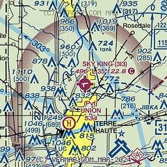
| Sectional chart |
|---|
|
| Airport distance calculator |
|---|
|
|
| Sunrise and sunset |
|---|
|
Times for 06-Dec-2025
| | Local
(UTC-5) | | Zulu
(UTC) |
|---|
| Morning civil twilight | | 07:27 | | 12:27 |
| Sunrise | | 07:57 | | 12:57 |
| Sunset | | 17:24 | | 22:24 |
| Evening civil twilight | | 17:54 | | 22:54 |
|
| Current date and time |
|---|
| Zulu (UTC) | 06-Dec-2025 15:44:05 |
|---|
| Local (UTC-5) | 06-Dec-2025 10:44:05 |
|---|
|
| METAR |
|---|
KHUF
6nm S | 061453Z 25008KT 10SM OVC035 01/M03 A2998 RMK AO2 SLP157 T00061028 51021
|
KPRG
16nm NW | 061515Z AUTO 28006KT 7SM OVC013 00/M02 A2998 RMK AO2 T00031017
|
|
| TAF |
|---|
KHUF
6nm S | 061133Z 0612/0712 22007KT P6SM OVC025 FM061500 26005KT P6SM BKN015 FM062100 24003KT P6SM SCT025 FM070400 14005KT P6SM BKN025 FM070700 17006KT 5SM BR SCT008 OVC015 PROB30 0707/0712 2SM -DZ BR SCT004 OVC006
|
|
| NOTAMs |
|---|
NOTAMs are issued by the DoD/FAA and will open in a separate window not controlled by AirNav.
|
|

