FAA INFORMATION EFFECTIVE 19 MARCH 2026
Location
| FAA Identifier: | 0I2 |
| Lat/Long: | 39-28-36.2480N 087-05-58.9530W
39-28.604133N 087-05.982550W
39.4767356,-87.0997092
(estimated) |
| Elevation: | 645 ft. / 196.6 m (surveyed) |
| Variation: | 04W (2020) |
| From city: | 3 miles S of BRAZIL, IN |
| Time zone: | UTC -4 (UTC -5 during Standard Time) |
| Zip code: | 47834 |
Airport Operations
| Airport use: | Open to the public |
| Activation date: | 01/1967 |
| Control tower: | no |
| ARTCC: | INDIANAPOLIS CENTER |
| FSS: | TERRE HAUTE FLIGHT SERVICE STATION |
| NOTAMs facility: | HUF (NOTAM-D service available) |
| Attendance: | UNATNDD |
| Wind indicator: | lighted |
| Segmented circle: | no |
| Lights: | ACTVT LIRL RY 09/27 - CTAF 3 SLOW CLICKS . |
| Beacon: | white-green (lighted land airport)
Operates sunset to sunrise. |
Airport Communications
| CTAF/UNICOM: | 122.8 |
| HULMAN APPROACH: | 125.45 134.725 |
| HULMAN DEPARTURE: | 125.45 134.725 |
| WX ASOS at HUF (10 nm W): | 127.5 (812-877-7010) |
| WX AWOS-3PT at GPC (16 nm NE): | 118.125 (765-653-1789) |
Nearby radio navigation aids
| VOR radial/distance | | VOR name | | Freq | | Var |
|---|
| TTHr094/7.0 | | TERRE HAUTE VORTAC | | 115.30 | | 02E |
| OOMr313/30.2 | | HOOSIER VORTAC | | 110.20 | | 02W |
| VHPr238/39.4 | | BRICKYARD VORTAC | | 116.30 | | 01E |
| NDB name | | Hdg/Dist | | Freq | | Var | | ID |
|---|
| YINNO | | 071/14.8 | | 245 | | 02W | | HU | .... ..- |
| CRAWFORDSVILLE | | 200/31.4 | | 388 | | 04W | | CFJ | -.-. ..-. .--- |
Airport Services
| Fuel available: | 100LL |
| Parking: | tiedowns |
| Bottled oxygen: | NONE |
| Bulk oxygen: | NONE |
Runway Information
Runway 9/27
| Dimensions: | 2941 x 40 ft. / 896 x 12 m |
| Surface: | asphalt, in good condition |
| Weight bearing capacity: | |
| Runway edge lights: | low intensity |
| RUNWAY 9 | | RUNWAY 27 |
| Latitude: | 39-28.609083N | | 39-28.599800N |
| Longitude: | 087-06.295217W | | 087-05.670167W |
| Elevation: | 645.0 ft. | | 631.0 ft. |
| Traffic pattern: | left | | left |
| Runway heading: | 095 magnetic, 091 true | | 275 magnetic, 271 true |
| Displaced threshold: | 620 ft. | | 442 ft. |
| Markings: | nonprecision, in good condition | | basic, in good condition |
| Runway end identifier lights: | no | | no |
| Touchdown point: | yes, no lights | | yes, no lights |
| Obstructions: | 75 ft. trees, 760 ft. from runway, 125 ft. left of centerline, 7:1 slope to clear
4 FT FENCE 28 FT FM RWY. | | 51 ft. trees, 350 ft. from runway, 140 ft. left of centerline, 2:1 slope to clear
PVT DRIVE 20 FT L. |
Airport Ownership and Management from official FAA records
| Ownership: | Publicly-owned |
| Owner: | BRAZIL-CLAY COUNTY BOAC
PO BOX 1
KNIGHTSVILLE, IN 47857
Phone (812) 240-2860 |
| Manager: | KIP CLARK
PO BOX 1
KNIGHTSVILLE, IN 47857
Phone 812-240-1552 |
Additional Remarks
| A30A-27 | 20 FT DEPRESSION E OF RWY END 100 FT N OF CNTRLN. |
| - | +80 FT WSW - ENE PLINE 4/5 MI N OF ARPT. |
| - | LARGE FLOCKS OF GEESE ON & INVOF ARPT. |
| - | FOR CD CTC HULMAN APCH AT 812-877-7581. |
Instrument Procedures
NOTE: All procedures below are presented as PDF files. If you need a reader for these files, you should download the free Adobe Reader.NOT FOR NAVIGATION. Please procure official charts for flight.
FAA instrument procedures published for use from 19 March 2026 at 0901Z to 16 April 2026 at 0900Z.
IAPs - Instrument Approach Procedures |
|---|
| RNAV (GPS) RWY 27 **CHANGED** | |
download (160KB) |
| NOTE: Special Take-Off Minimums/Departure Procedures apply **CHANGED** | |
download (495KB) |
Other nearby airports with instrument procedures:
KHUF - Terre Haute Regional Airport (10 nm W)
3I3 - Sky King Airport (14 nm W)
KGPC - Putnam County Regional Airport (16 nm NE)
KSIV - Sullivan County Airport (27 nm SW)
KPRG - Edgar County Airport (30 nm NW)
|
|

Road maps at:
MapQuest
Bing
Google
| Aerial photo |
|---|
WARNING: Photo may not be current or correct
 Photo taken 14-Jul-2017
looking east.
Photo taken 14-Jul-2017
looking east.
Do you have a better or more recent aerial photo of Brazil Clay County Airport/Charles B Hall Field that you would like to share? If so, please send us your photo.
|
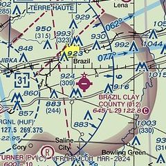
| Sectional chart |
|---|
|
| Airport distance calculator |
|---|
|
|
| Sunrise and sunset |
|---|
|
Times for 04-Apr-2026
| | Local
(UTC-4) | | Zulu
(UTC) |
|---|
| Morning civil twilight | | 07:02 | | 11:02 |
| Sunrise | | 07:29 | | 11:29 |
| Sunset | | 20:14 | | 00:14 |
| Evening civil twilight | | 20:41 | | 00:41 |
|
| Current date and time |
|---|
| Zulu (UTC) | 04-Apr-2026 20:03:07 |
|---|
| Local (UTC-4) | 04-Apr-2026 16:03:07 |
|---|
|
| METAR |
|---|
KHUF
11nm W | 041953Z 27011G19KT 3SM -RA BR OVC010 13/12 A2997 RMK AO2 RAB23 SLP148 P0001 T01280117
|
KGPC
16nm NE | 041955Z AUTO 28015G18KT 10SM OVC008 14/ A2995 RMK AO2 P0001 T0136////
|
|
| TAF |
|---|
KHUF
11nm W | 041720Z 0418/0518 24013G21KT 6SM -SHRA OVC015 TEMPO 0418/0420 3SM -SHRA BR BKN009 FM042000 28014G24KT P6SM VCSH BKN025 FM050000 29012G20KT P6SM SCT025 BKN050 FM050500 28012KT P6SM SCT050 BKN100 FM051300 31012G20KT P6SM BKN025
|
|
| NOTAMs |
|---|
NOTAMs are issued by the DoD/FAA and will open in a separate window not controlled by AirNav.
|
|

