FAA INFORMATION EFFECTIVE 09 JULY 2026
Location
| FAA Identifier: | 3T5 |
| Lat/Long: | 29-54-28.7000N 096-57-00.0000W
29-54.478333N 096-57.000000W
29.9079722,-96.9500000
(estimated) |
| Elevation: | 324 ft. / 98.8 m (surveyed) |
| Variation: | 06E (2000) |
| From city: | 2 miles W of LA GRANGE, TX |
| Time zone: | UTC -5 (UTC -6 during Standard Time) |
| Zip code: | 78945 |
Airport Operations
| Airport use: | Open to the public |
| Activation date: | 01/1992 |
| Control tower: | no |
| ARTCC: | HOUSTON CENTER |
| FSS: | MONTGOMERY COUNTY FLIGHT SERVICE STATION |
| NOTAMs facility: | 3T5 (NOTAM-D service available) |
| Attendance: | MON-FRI 0900-1700
FOR ARPT ATTENDANT AFT HRS CALL 979-966-9139. |
| Wind indicator: | lighted |
| Segmented circle: | yes |
| Lights: | DUSK-DAWN. MIRL RWY 16/34 PRESET LOW INTST; TO INCR INTST ACTVT CTAF. |
| Beacon: | white-green (lighted land airport)
Operates sunset to sunrise. |
Airport Communications
| CTAF/UNICOM: | 122.7 |
| WX AWOS-3: | 124.175 (979-242-5777) |
| AUSTIN APPROACH: | 120.875 [1345-0600Z++ MON-THU; 1345-2345Z++ FRI; CLSD SAT, SUN AND HOL EXC BY NOTAM, HRS SUBJ TO CHG.] |
| AUSTIN DEPARTURE: | 120.875 [1345-0600Z++ MON-THU; 1345-2345Z++ FRI; CLSD SAT, SUN AND HOL EXC BY NOTAM, HRS SUBJ TO CHG.] |
| WX AWOS-3 at GYB (16 nm N): | 119.225 (979-542-0382) |
Airport Services
| Fuel available: | 100LL JET-A |
| Parking: | tiedowns |
| Airframe service: | NONE |
| Powerplant service: | NONE |
Runway Information
Runway 16/34
| Dimensions: | 5000 x 75 ft. / 1524 x 23 m |
| Surface: | asphalt, in good condition |
| Weight bearing capacity: | |
| Runway edge lights: | medium intensity |
| RUNWAY 16 | | RUNWAY 34 |
| Latitude: | 29-54.872333N | | 29-54.085667N |
| Longitude: | 096-57.143333W | | 096-56.858167W |
| Elevation: | 307.7 ft. | | 324.0 ft. |
| Traffic pattern: | left | | left |
| Runway heading: | 156 magnetic, 162 true | | 336 magnetic, 342 true |
| Markings: | nonprecision, in good condition | | nonprecision, in good condition |
| Visual slope indicator: | 2-light PAPI on left (3.00 degrees glide path) | | 2-light PAPI on left (3.00 degrees glide path) |
| Runway end identifier lights: | yes | | yes |
| Touchdown point: | yes, no lights | | yes, no lights |
| Obstructions: | none | | 15 ft. trees, 475 ft. from runway, 110 ft. left of centerline, 18:1 slope to clear |
Airport Ownership and Management from official FAA records
| Ownership: | Publicly-owned |
| Owner: | FAYETTE COUNTY
COUNTY COURTHOUSE, 151 N. WASHINGTON ST.
LA GRANGE, TX 78945
Phone 979-968-6469 |
| Manager: | DEBRA MADDOX
850 AIRPORT ROAD
LA GRANGE, TX 78945
Phone 979-242-4056 |
Additional Remarks
| - | GCO AVBL ON FREQ 121.725 THRU AUSTIN APCH CTL & FLT SVCS. |
| - | FOR CD CTC AUSTIN APCH AT 512-369-7865. |
Instrument Procedures
NOTE: All procedures below are presented as PDF files. If you need a reader for these files, you should download the free Adobe Reader.NOT FOR NAVIGATION. Please procure official charts for flight.
FAA instrument procedures published for use from 09 July 2026 at 0901Z to 06 August 2026 at 0900Z.
IAPs - Instrument Approach Procedures |
|---|
| RNAV (GPS) RWY 16 **CHANGED** | |
download (188KB) |
| RNAV (GPS) RWY 34 **CHANGED** | |
download (198KB) |
| NOTE: Special Alternate Minimums apply | |
download (14KB) |
| NOTE: Special Take-Off Minimums/Departure Procedures apply | |
download (118KB) |
Other nearby airports with instrument procedures:
84R - Smithville Crawford Municipal Airport (13 nm NW)
KGYB - Giddings-Lee County Airport (16 nm N)
11R - Brenham Municipal Airport (35 nm NE)
T85 - Yoakum Municipal Airport (37 nm S)
KELA - Eagle Lake Airport (38 nm SE)
|
|

Road maps at:
MapQuest
Bing
Google
| Aerial photo |
|---|
WARNING: Photo may not be current or correct
 Photo taken 14-Mar-2006
Do you have a better or more recent aerial photo of Fayette Regional Air Center Airport that you would like to share? If so, please send us your photo.
|
| Sectional chart |
|---|
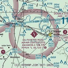
|
 Download PDF
of official airport diagram from the FAA
| Airport distance calculator |
|---|
|
|
| Sunrise and sunset |
|---|
|
Times for 25-Jul-2026
| | Local
(UTC-5) | | Zulu
(UTC) |
|---|
| Morning civil twilight | | 06:17 | | 11:17 |
| Sunrise | | 06:44 | | 11:44 |
| Sunset | | 20:25 | | 01:25 |
| Evening civil twilight | | 20:51 | | 01:51 |
|
| Current date and time |
|---|
| Zulu (UTC) | 25-Jul-2026 19:03:15 |
|---|
| Local (UTC-5) | 25-Jul-2026 14:03:15 |
|---|
|
| METAR |
|---|
| K3T5 | 251855Z AUTO 18009KT 10SM SCT047 BKN290 BKN320 33/21 A3009 RMK AO2 T03290207 $
|
KGYB
16nm N | 251835Z AUTO 20007KT 10SM SCT044 32/21 A3013 RMK AO2 T03220212
|
|
| TAF |
|---|
KAUS
45nm NW | 251720Z 2518/2624 19010KT P6SM SCT050 FM261000 19004KT P6SM SCT025 FM261500 19010KT P6SM SCT050
|
|
| NOTAMs |
|---|
NOTAMs are issued by the DoD/FAA and will open in a separate window not controlled by AirNav.
|
|


