FAA INFORMATION EFFECTIVE 15 MAY 2025
Location
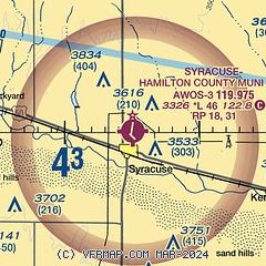
| FAA Identifier: | 3K3 |
| Lat/Long: | 37-59-54.8990N 101-44-51.3880W
37-59.914983N 101-44.856467W
37.9985831,-101.7476078
(estimated) |
| Elevation: | 3326.1 ft. / 1014 m (estimated) |
| Variation: | 07E (2010) |
| From city: | 1 mile N of SYRACUSE, KS |
| Time zone: | UTC -6 (UTC -7 during Standard Time) |
| Zip code: | 67878 |
Airport Operations
| Airport use: | Open to the public |
| Activation date: | 04/1940 |
| Control tower: | no |
| ARTCC: | DENVER CENTER |
| FSS: | WICHITA FLIGHT SERVICE STATION |
| NOTAMs facility: | ICT (NOTAM-D service available) |
| Attendance: | MON-FRI 0800-1700
FOR ATTENDANT AFT HRS CALL 620-384-5835 |
| Wind indicator: | lighted |
| Segmented circle: | no |
| Lights: | DUSK-DAWN. ACTVT MIRL RWY 13/31 & RWY 18/36; PAPI RWY 18 & 36 - CTAF. |
| Beacon: | white-green (lighted land airport)
Operates sunset to sunrise. |
Airport Communications
| CTAF/UNICOM: | 122.8 |
| WX AWOS-3PT: | 119.975 (620-384-5869) |
- APCH/DEP CTL SVC PRVDD BY DENVER ARTCC (ZDV) ON FREQS 133.4/377.175 (LA JUNTA RCAG).
Airport Services
| Fuel available: | 100LL |
| Parking: | hangars and tiedowns |
| Airframe service: | MINOR |
| Powerplant service: | MINOR |
| Bottled oxygen: | NONE |
| Bulk oxygen: | NONE |
Runway Information
Runway 18/36
| Dimensions: | 4600 x 75 ft. / 1402 x 23 m |
| Surface: | concrete, in good condition |
| Weight bearing capacity: | | PCN 11 /R/C/X/U | | Single wheel: | 30.0 | | Double wheel: | 30.0 |
|
| Runway edge lights: | medium intensity |
| RUNWAY 18 | | RUNWAY 36 |
| Latitude: | 38-00.481500N | | 37-59.734500N |
| Longitude: | 101-44.784667W | | 101-44.946500W |
| Elevation: | 3326.1 ft. | | 3314.9 ft. |
| Traffic pattern: | right | | left |
| Runway heading: | 183 magnetic, 190 true | | 003 magnetic, 010 true |
| Markings: | nonprecision, in good condition | | nonprecision, in good condition |
| Visual slope indicator: | 4-light PAPI on right (3.00 degrees glide path) | | 4-light PAPI on left (3.20 degrees glide path) |
| Touchdown point: | yes, no lights | | yes, no lights |
| Obstructions: | 55 ft. pline, marked, 1327 ft. from runway, 20:1 slope to clear | | 25 ft. bldg, marked and lighted, 426 ft. from runway, 395 ft. left of centerline, 9:1 slope to clear |
Runway 13/31
| Dimensions: | 3000 x 40 ft. / 914 x 12 m |
| Surface: | asphalt, in good condition |
| Weight bearing capacity: | |
| Runway edge lights: | medium intensity |
| RUNWAY 13 | | RUNWAY 31 |
| Latitude: | 37-59.793433N | | 37-59.443783N |
| Longitude: | 101-45.063233W | | 101-44.621767W |
| Elevation: | 3312.2 ft. | | 3303.0 ft. |
| Traffic pattern: | left | | right |
| Runway heading: | 128 magnetic, 135 true | | 308 magnetic, 315 true |
| Displaced threshold: | no | | 355 ft. |
| Markings: | basic, in fair condition | | basic, in fair condition |
| Touchdown point: | yes, no lights | | yes, no lights |
| Obstructions: | 15 ft. road, 220 ft. from runway, 1:1 slope to clear | | 26 ft. tree, 373 ft. from runway, 171 ft. left of centerline, 6:1 slope to clear
+15 ROAD 125 FT R; 115 FT FRM RWY 31 END. |
Airport Ownership and Management from official FAA records
| Ownership: | Publicly-owned |
| Owner: | CITY OF SYRACUSE/HAMILTON CO
BOX 1136
SYRACUSE, KS 67878
Phone 620-384-5629 |
| Manager: | STEVE PHILLIPS
BOX 1136
SYRACUSE, KS 67878
Phone 620-384-5468 |
Additional Remarks
| - | PUBLIC PHONE 620-384-5835. |
| - | FOR CD CTC DENVER ARTCC AT 303-651-4257. |
Instrument Procedures
NOTE: All procedures below are presented as PDF files. If you need a reader for these files, you should download the free Adobe Reader.NOT FOR NAVIGATION. Please procure official charts for flight.
FAA instrument procedures published for use from 15 May 2025 at 0901Z to 13 June 2025 at 0900z.
IAPs - Instrument Approach Procedures |
|---|
| RNAV (GPS) RWY 18 | |
download (263KB) |
| RNAV (GPS) RWY 36 | |
download (273KB) |
| NOTE: Special Alternate Minimums apply | |
download (146KB) |
| NOTE: Special Take-Off Minimums/Departure Procedures apply | |
download (356KB) |
Other nearby airports with instrument procedures:
KJHN - Stanton County Municipal Airport (25 nm S)
5K2 - Tribune Municipal Airport (27 nm N)
KULS - Ulysses Airport (30 nm SE)
3K7 - Mark Hoard Memorial Airport (33 nm NE)
KLAA - Southeast Colorado Regional Airport (45 nm W)
|
|

Road maps at:
MapQuest
Bing
Google
| Aerial photo |
|---|
WARNING: Photo may not be current or correct
 Photo taken 07-Sep-2007
Do you have a better or more recent aerial photo of Syracuse-Hamilton County Municipal Airport that you would like to share? If so, please send us your photo.
|
| Sectional chart |
|---|
|
| Airport distance calculator |
|---|
|
|
| Sunrise and sunset |
|---|
|
Times for 24-May-2025
| | Local
(UTC-6) | | Zulu
(UTC) |
|---|
| Morning civil twilight | | 05:01 | | 11:01 |
| Sunrise | | 05:31 | | 11:31 |
| Sunset | | 19:57 | | 01:57 |
| Evening civil twilight | | 20:27 | | 02:27 |
|
| Current date and time |
|---|
| Zulu (UTC) | 24-May-2025 07:47:41 |
|---|
| Local (UTC-6) | 24-May-2025 01:47:41 |
|---|
|
| METAR |
|---|
| K3K3 | 240735Z AUTO 11013G20KT 10SM SCT033 19/19 A2987 RMK AO2 PK WND 13033/42
|
|
| TAF |
|---|
KGCK
49nm E | 240520Z 2406/2506 07012KT P6SM BKN015 FM240900 07012KT P6SM OVC007 FM241900 08012KT P6SM OVC015 FM250200 07012KT P6SM OVC007 FM250400 06012KT P6SM OVC004
|
|
| NOTAMs |
|---|
NOTAMs are issued by the DoD/FAA and will open in a separate window not controlled by AirNav.
|
|


