FAA INFORMATION EFFECTIVE 15 MAY 2025
Location
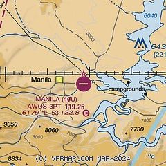
| FAA Identifier: | 40U |
| Lat/Long: | 40-59-11.0200N 109-40-42.6970W
40-59.183667N 109-40.711617W
40.9863944,-109.6785269
(estimated) |
| Elevation: | 6178.7 ft. / 1883 m (estimated) |
| Variation: | 14E (1985) |
| From city: | 2 miles E of MANILA, UT |
| Time zone: | UTC -6 (UTC -7 during Standard Time) |
| Zip code: | 84046 |
Airport Operations
| Airport use: | Open to the public |
| Activation date: | 11/1969 |
| Control tower: | no |
| ARTCC: | SALT LAKE CITY CENTER |
| FSS: | CEDAR CITY FLIGHT SERVICE STATION |
| NOTAMs facility: | CDC (NOTAM-D service available) |
| Attendance: | UNATTND |
| Wind indicator: | yes |
| Segmented circle: | yes |
| Lights: | SS-SR |
| Beacon: | white-green (lighted land airport)
Operates sunset to sunrise. |
Airport Communications
| CTAF/UNICOM: | 122.8 |
| WX AWOS-3PT: | 119.250 (435-784-3123) |
Nearby radio navigation aids
| VOR radial/distance | | VOR name | | Freq | | Var |
|---|
| VELr332/37.4 | | VERNAL VOR/DME | | 114.15 | | 15E |
Airport Services
| Parking: | tiedowns |
| Airframe service: | NONE |
| Powerplant service: | NONE |
| Bottled oxygen: | NONE |
| Bulk oxygen: | NONE |
Runway Information
Runway 7/25
| Dimensions: | 5305 x 60 ft. / 1617 x 18 m |
| Surface: | asphalt, in good condition |
| Weight bearing capacity: | |
| Runway edge lights: | medium intensity |
| RUNWAY 7 | | RUNWAY 25 |
| Latitude: | 40-59.179250N | | 40-59.188052N |
| Longitude: | 109-41.287858W | | 109-40.135380W |
| Elevation: | 6178.7 ft. | | 6115.3 ft. |
| Traffic pattern: | left | | left |
| Runway heading: | 075 magnetic, 089 true | | 255 magnetic, 269 true |
| Markings: | basic, in good condition | | basic, in good condition |
| Touchdown point: | yes, no lights | | yes, no lights |
| Obstructions: | 21 ft. hill, 634 ft. from runway, 20:1 slope to clear
CTLG OBSTN EXCEEDS A 45 DEG SLP. | | 25 ft. trees, 201 ft. from runway, 120 ft. right of centerline
4-15 FT TREES, 0-199 FT DSTC, 0-125 FT R. |
Airport Ownership and Management from official FAA records
| Ownership: | Publicly-owned |
| Owner: | DAGGETT COUNTY
95 N. 1ST W, PO BOX 219
MANILA, UT 84046-0219
Phone 435-784-3154 |
| Manager: | KENT BOND
95 NORTH 1ST WEST, PO BOX 219
MANILA, UT 84046-0219
Phone 801-913-5223
COUNTY CLERK/ARPT MGR. |
Additional Remarks
| - | 3 TO 6 FT DITCH PARL TO RWY, 40 FT EACH SIDE OF CNTRLN. |
| - | FOR CD CTC SALT LAKE ARTCC AT 801-320-2568. |
| - | SN PLOWING IREG. CALL FOR FICONS. |
Instrument Procedures
There are no published instrument procedures at 40U.
Some nearby airports with instrument procedures:
KVEL - Vernal Regional Airport (34 nm S)
KFBR - Fort Bridger Airport (41 nm NW)
74V - Roosevelt Municipal Airport (46 nm S)
KRKS - Southwest Wyoming Regional Airport (46 nm NE)
U69 - Duchesne Municipal Airport (57 nm SW)
|
|

Road maps at:
MapQuest
Bing
Google
| Aerial photo |
|---|
WARNING: Photo may not be current or correct
 Photo courtesy of www.axenty.com
Photo taken 31-Jan-2009
looking west.
Photo courtesy of www.axenty.com
Photo taken 31-Jan-2009
looking west.
Do you have a better or more recent aerial photo of Manila Airport that you would like to share? If so, please send us your photo.
|
| Sectional chart |
|---|
|
| Airport distance calculator |
|---|
|
|
| Sunrise and sunset |
|---|
|
Times for 31-May-2025
| | Local
(UTC-6) | | Zulu
(UTC) |
|---|
| Morning civil twilight | | 05:17 | | 11:17 |
| Sunrise | | 05:50 | | 11:50 |
| Sunset | | 20:43 | | 02:43 |
| Evening civil twilight | | 21:15 | | 03:15 |
|
| Current date and time |
|---|
| Zulu (UTC) | 01-Jun-2025 04:27:38 |
|---|
| Local (UTC-6) | 31-May-2025 22:27:38 |
|---|
|
| METAR |
|---|
KVEL
33nm S | 010353Z AUTO 35007KT 10SM CLR 24/01 A3000 RMK AO2 SLP085 T02440011
|
KFBR
41nm NW | 010415Z AUTO 25005KT 10SM CLR 19/M01 A3021 RMK AO2 T01881006
|
K74V
46nm S | 010415Z AUTO 18004KT 10SM CLR 23/04 A3000 RMK AO2
|
KRKS
46nm NE | 010354Z AUTO 26006KT 10SM CLR 22/M01 A3013 RMK AO2 SLP115 T02171011
|
|
| TAF |
|---|
KVEL
33nm S | 311740Z 3118/0118 07006KT P6SM SKC FM010200 36006KT P6SM SKC FM011200 VRB03KT P6SM SKC
|
|
| NOTAMs |
|---|
NOTAMs are issued by the DoD/FAA and will open in a separate window not controlled by AirNav.
|
|


