FAA INFORMATION EFFECTIVE 07 AUGUST 2025
Location
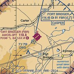
| FAA Identifier: | FBR |
| Lat/Long: | 41-23-36.0000N 110-24-21.5000W
41-23.600000N 110-24.358333W
41.3933333,-110.4059722
(estimated) |
| Elevation: | 7038 ft. / 2145.2 m (surveyed) |
| Variation: | 11E (2015) |
| From city: | 4 miles N of FORT BRIDGER, WY |
| Time zone: | UTC -6 (UTC -7 during Standard Time) |
| Zip code: | 82937 |
Airport Operations
| Airport use: | Open to the public |
| Activation date: | 07/1941 |
| Control tower: | no |
| ARTCC: | SALT LAKE CITY CENTER |
| FSS: | CASPER FLIGHT SERVICE STATION |
| NOTAMs facility: | CPR (NOTAM-D service available) |
| Attendance: | UNATNDD
FOR SVC AFT HRS CALL 307-799-5513. |
| Wind indicator: | lighted |
| Segmented circle: | no |
| Lights: | ACTVT PAPI RWY 04 & 22; REIL RWY 04 & 22; MIRL RWY 04/22 - CTAF. |
| Beacon: | white-green (lighted land airport)
Operates sunset to sunrise. |
Airport Communications
| CTAF/UNICOM: | 122.8 |
| WX AWOS-3PT: | 118.8 (307-782-3226) |
- COMMUNICATIONS PRVDD BY CASPER RADIO ON FREQ 122.3 (FORT BRIDGER RCO).
- APCH/DEP CTL SVC PRVDD BY SALT LAKE ARTCC (ZLC) ON 124.35/353.5 (GREEN RIVER RCAG).
Nearby radio navigation aids
| VOR radial/distance | | VOR name | | Freq | | Var |
|---|
| FBRr028/1.2 | | FORT BRIDGER VOR/DME | | 114.45 | | 14E |
| EVWr063/29.8 | | EVANSTON VOR/DME | | 109.60 | | 13E |
Airport Services
| Fuel available: | 100LL
100LL:FUEL AVBL H24 VIA CREDIT CARD. |
| Parking: | tiedowns |
| Airframe service: | NONE |
| Powerplant service: | NONE |
| Bottled oxygen: | NONE |
| Bulk oxygen: | NONE |
Runway Information
Runway 4/22
| Dimensions: | 6404 x 75 ft. / 1952 x 23 m |
| Surface: | asphalt, in fair condition |
| Weight bearing capacity: | | Single wheel: | 12.5 | | Double wheel: | 20.0 | | Double tandem: | 20.0 |
|
| Runway edge lights: | medium intensity |
| RUNWAY 4 | | RUNWAY 22 |
| Latitude: | 41-23.209658N | | 41-23.822832N |
| Longitude: | 110-24.977380W | | 110-23.838703W |
| Elevation: | 7038.0 ft. | | 7007.5 ft. |
| Traffic pattern: | left | | left |
| Runway heading: | 043 magnetic, 054 true | | 223 magnetic, 234 true |
| Markings: | nonprecision, in good condition | | nonprecision, in good condition |
| Visual slope indicator: | 2-light PAPI on left (3.00 degrees glide path) | | 2-light PAPI on left (3.00 degrees glide path) |
| Runway end identifier lights: | yes | | yes |
| Touchdown point: | yes, no lights | | yes, no lights |
Runway 7/25
| Dimensions: | 3520 x 50 ft. / 1073 x 15 m |
| Surface: | turf/dirt, in fair condition |
| RUNWAY 7 | | RUNWAY 25 |
| Latitude: | 41-23.694013N | | 41-23.806627N |
| Longitude: | 110-24.647243W | | 110-23.892462W |
| Elevation: | 7019.7 ft. | | 7008.9 ft. |
| Traffic pattern: | left | | left |
| Runway heading: | 068 magnetic, 079 true | | 248 magnetic, 259 true |
| Markings: | none, in fair condition | | none, in fair condition |
| Touchdown point: | yes, no lights | | yes, no lights |
| Obstructions: | 12 ft. fence, 450 ft. from runway, 62 ft. right of centerline, 38:1 slope to clear | | none |
Airport Ownership and Management from official FAA records
| Ownership: | Publicly-owned |
| Owner: | UINTA COUNTY
P O BOX 810
EVANSTON, WY 82931
Phone 307-783-0415 |
| Manager: | JEFF BREININGER
225 9TH STREET
EVANSTON, WY 82930
Phone 307-783-0507 |
Additional Remarks
| - | RWY 04/22 PLOWED WINTER MONTHS; RWY 07/25 CLSD WINTER MONTHS EXCEPT FOR SKI EQUIP ACFT; DIRT/TURF RWYS NOT MAINTAINED. |
| - | FOR CD IF UNA TO CTC ON FSS FREQ, CTC SALT LAKE ARTCC AT 801-320-2568. |
Instrument Procedures
NOTE: All procedures below are presented as PDF files. If you need a reader for these files, you should download the free Adobe Reader.NOT FOR NAVIGATION. Please procure official charts for flight.
FAA instrument procedures published for use from 07 August 2025 at 0901Z to 04 September 2025 at 0900z.
IAPs - Instrument Approach Procedures |
|---|
| RNAV (GPS) RWY 22 **CHANGED** | |
download (202KB) |
| VOR RWY 22 **CHANGED** | |
download (187KB) |
| NOTE: Special Take-Off Minimums/Departure Procedures apply | |
download (559KB) |
Other nearby airports with instrument procedures:
KEMM - Kemmerer Municipal Airport (27 nm N)
KEVW - Evanston-Uinta County Airport - Burns Field (29 nm W)
KRKS - Southwest Wyoming Regional Airport (61 nm E)
1U7 - Bear Lake County Airport (66 nm NW)
74V - Roosevelt Municipal Airport (69 nm S)
|
|

Road maps at:
MapQuest
Bing
Google
| Aerial photo |
|---|
WARNING: Photo may not be current or correct

Do you have a better or more recent aerial photo of Fort Bridger Airport that you would like to share? If so, please send us your photo.
|
| Sectional chart |
|---|
|
| Airport distance calculator |
|---|
|
|
| Sunrise and sunset |
|---|
|
Times for 02-Sep-2025
| | Local
(UTC-6) | | Zulu
(UTC) |
|---|
| Morning civil twilight | | 06:22 | | 12:22 |
| Sunrise | | 06:50 | | 12:50 |
| Sunset | | 19:53 | | 01:53 |
| Evening civil twilight | | 20:21 | | 02:21 |
|
| Current date and time |
|---|
| Zulu (UTC) | 02-Sep-2025 21:14:51 |
|---|
| Local (UTC-6) | 02-Sep-2025 15:14:51 |
|---|
|
| METAR |
|---|
| KFBR | 022055Z AUTO 34012G17KT 10SM CLR 28/M06 A3041 RMK AO2 T02831062
|
|
| TAF |
|---|
KEVW
29nm W | 021725Z 0218/0318 VRB04KT P6SM SKC FM022000 34010KT P6SM FEW120 FM030300 VRB05KT P6SM SKC
|
|
| NOTAMs |
|---|
NOTAMs are issued by the DoD/FAA and will open in a separate window not controlled by AirNav.
|
|

