FAA INFORMATION EFFECTIVE 25 DECEMBER 2025
Location
| FAA Identifier: | VEL |
| Lat/Long: | 40-26-09.8800N 109-30-41.1210W
40-26.164667N 109-30.685350W
40.4360778,-109.5114225
(estimated) |
| Elevation: | 5274.2 ft. / 1607.6 m (surveyed) |
| Variation: | 10E (2020) |
| From city: | 1 mile SE of VERNAL, UT |
| Time zone: | UTC -7 (UTC -6 during Daylight Saving Time) |
| Zip code: | 84078 |
Airport Operations
| Airport use: | Open to the public |
| Activation date: | 05/1945 |
| Control tower: | no |
| ARTCC: | SALT LAKE CITY CENTER |
| FSS: | CEDAR CITY FLIGHT SERVICE STATION |
| NOTAMs facility: | VEL (NOTAM-D service available) |
| Attendance: | DAWN-DUSK
AFT HR OPS CTC 435-789-8494 OR 435-261-9000. |
| Wind indicator: | lighted |
| Segmented circle: | yes |
| Lights: | ACTVT REIL RWY 17 & 35; MIRL RWY 17/35 - CTAF. PAPI RWY 17 & 35 ON CONSLY. |
| Beacon: | white-green (lighted land airport)
Operates sunset to sunrise. |
| Fire and rescue: | ARFF index A |
| Airline operations: | 24 HR PPR FOR ACR OPS OVR 30 PAX SEATS - AMGR. |
Airport Communications
| CTAF/UNICOM: | 122.7 |
| WX ASOS: | 118.125 (435-781-1224) |
- APCH/DEP CTL SVC PRVDD BY SALT LAKE ARTCC (ZLC) ON 119.95/377.15 MYTON RCAG).
Nearby radio navigation aids
| VOR radial/distance | | VOR name | | Freq | | Var |
|---|
| VELr331/3.5 | | VERNAL VOR/DME | | 114.15 | | 15E |
| MTUr045/33.0 | | MYTON VOR/DME | | 112.70 | | 14E |
Airport Services
| Fuel available: | 100LL JET-A |
| Parking: | hangars and tiedowns |
| Airframe service: | MAJOR |
| Powerplant service: | MAJOR |
| Bulk oxygen: | HIGH/LOW |
Runway Information
Runway 17/35
| Dimensions: | 7000 x 100 ft. / 2134 x 30 m |
| Surface: | asphalt/grooved, in excellent condition |
| Weight bearing capacity: | | Single wheel: | 45.0 | | Double wheel: | 55.0 |
|
| Runway edge lights: | medium intensity |
| RUNWAY 17 | | RUNWAY 35 |
| Latitude: | 40-26.740883N | | 40-25.588463N |
| Longitude: | 109-30.698103W | | 109-30.672615W |
| Elevation: | 5267.8 ft. | | 5274.2 ft. |
| Traffic pattern: | left | | left |
| Runway heading: | 169 magnetic, 179 true | | 349 magnetic, 359 true |
| Declared distances: | TORA:7000 | | TORA:7000 |
| Markings: | nonprecision, in good condition | | nonprecision, in good condition |
| Visual slope indicator: | 4-light PAPI on left (3.00 degrees glide path) | | 4-light PAPI on left (3.00 degrees glide path) |
| Runway end identifier lights: | yes | | yes |
| Touchdown point: | yes, no lights | | yes, no lights |
| Obstructions: | 33 ft. pole, 586 ft. from runway, 367 ft. left of centerline, 11:1 slope to clear | | 44 ft. trees, 1094 ft. from runway, 203 ft. right of centerline, 20:1 slope to clear |
Airport Ownership and Management from official FAA records
| Ownership: | Publicly-owned |
| Owner: | UINTAH CO AND VERNAL CITY
152 E 100 N.
VERNAL, UT 84078
Phone (435) 781-0770 |
| Manager: | KEN CAMPBELL
730 EAST 800 S.
VERNAL, UT 84078
Phone (435) 789-3400 |
Additional Remarks
| A39-17/35 | PCR VALUE: 230/F/D/X/T |
| - | RWY 07/25 DECOMMISSIONED. |
| - | FOR CD IF UNA TO CTC ON FSS FREQ, CTC SALT LAKE ARTCC AT 801-320-2568. |
| - | COLD TEMPERATURE AIRPORT. ALTITUDE CORRECTION REQUIRED AT OR BELOW -26C. |
Instrument Procedures
NOTE: All procedures below are presented as PDF files. If you need a reader for these files, you should download the free Adobe Reader.NOT FOR NAVIGATION. Please procure official charts for flight.
FAA instrument procedures published for use from 25 December 2025 at 0901z to 22 January 2026 at 0900z.
IAPs - Instrument Approach Procedures |
|---|
| RNAV (GPS) Y RWY 35 **CHANGED** | |
download (224KB) |
| RNAV (GPS) Z RWY 35 **CHANGED** | |
download (209KB) |
| VOR RWY 35 **CHANGED** | |
download (199KB) |
| NOTE: Special Alternate Minimums apply | |
download (128KB) |
| NOTE: Special Take-Off Minimums/Departure Procedures apply | |
download (227KB) |
Other nearby airports with instrument procedures:
74V - Roosevelt Municipal Airport (26 nm W)
4V0 - Rangely Airport (40 nm SE)
U69 - Duchesne Municipal Airport (42 nm W)
KFBR - Fort Bridger Airport (70 nm NW)
KRKS - Southwest Wyoming Regional Airport (72 nm N)
|
|

Road maps at:
MapQuest
Bing
Google
| Aerial photo |
|---|
WARNING: Photo may not be current or correct
 Photo taken 21-Dec-2017
looking north.
Photo taken 21-Dec-2017
looking north.
Do you have a better or more recent aerial photo of Vernal Regional Airport that you would like to share? If so, please send us your photo.
|
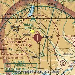
| Sectional chart |
|---|
|
CAUTION: Diagram may not be current

| Airport distance calculator |
|---|
|
|
| Sunrise and sunset |
|---|
|
Times for 19-Jan-2026
| | Local
(UTC-7) | | Zulu
(UTC) |
|---|
| Morning civil twilight | | 07:09 | | 14:09 |
| Sunrise | | 07:38 | | 14:38 |
| Sunset | | 17:19 | | 00:19 |
| Evening civil twilight | | 17:49 | | 00:49 |
|
| Current date and time |
|---|
| Zulu (UTC) | 20-Jan-2026 03:12:50 |
|---|
| Local (UTC-7) | 19-Jan-2026 20:12:50 |
|---|
|
| METAR |
|---|
| KVEL | 200253Z AUTO 32005KT 10SM CLR M02/M10 A3029 RMK AO2 SLP297 T10221100 53008 $
|
|
| TAF |
|---|
| KVEL | 191720Z 1918/2018 VRB03KT P6SM SKC FM200200 28003KT P6SM SKC
|
|
| NOTAMs |
|---|
NOTAMs are issued by the DoD/FAA and will open in a separate window not controlled by AirNav.
|
|


