FAA INFORMATION EFFECTIVE 19 FEBRUARY 2026
Location
| FAA Identifier: | 42B |
| Lat/Long: | 41-26-44.3560N 072-27-20.3130W
41-26.739267N 072-27.338550W
41.4456544,-72.4556425
(estimated) |
| Elevation: | 9 ft. / 3 m (estimated) |
| Variation: | 14W (1985) |
| From city: | 1 mile SE of EAST HADDAM, CT |
| Time zone: | UTC -5 (UTC -4 during Daylight Saving Time) |
| Zip code: | 06423 |
Airport Operations
| Airport use: | Open to the public |
| Activation date: | 11/1964 |
| Control tower: | no |
| ARTCC: | NEW YORK CENTER |
| FSS: | BRIDGEPORT FLIGHT SERVICE STATION |
| NOTAMs facility: | BDR (NOTAM-D service available) |
| Attendance: | UNATNDD |
| Wind indicator: | lighted |
| Segmented circle: | no |
| Lights: | ARPT LGTS OPR 24/7. |
| Landing fee: | yes, OVNGT PRKG FEE. |
Airport Communications
| CTAF/UNICOM: | 122.8 |
| WX AWOS-3 at SNC (4 nm SW): | 118.325 (860-526-1551) |
| WX ASOS at MMK (17 nm W): | 134.925 (203-639-9405) |
| WX ASOS at HFD (20 nm NW): | PHONE 860-952-9954 |
| WX ASOS at GON (20 nm E): | 127.0 (860-449-8921) |
Nearby radio navigation aids
| VOR radial/distance | | VOR name | | Freq | | Var |
|---|
| HFDr174/12.4 | | HARTFORD VOR/DME | | 114.90 | | 13W |
| MADr066/13.3 | | MADISON VOR/DME | | 110.40 | | 13W |
| GONr305/19.4 | | GROTON VOR/DME | | 110.85 | | 14W |
| ORWr266/21.6 | | NORWICH VOR/DME | | 110.00 | | 14W |
| HTOr002/32.2 | | HAMPTON VORTAC | | 113.60 | | 13W |
| CCCr040/34.6 | | CALVERTON VOR/DME | | 114.55 | | 13W |
| BDRr072/34.7 | | BRIDGEPORT VOR/DME | | 108.80 | | 12W |
Airport Services
| Parking: | tiedowns |
| Airframe service: | MAJOR |
| Powerplant service: | MAJOR |
Runway Information
Runway 14/32
| Dimensions: | 2120 x 50 ft. / 646 x 15 m |
| Surface: | asphalt, in good condition |
| Weight bearing capacity: | |
| Runway edge lights: | low intensity |
| RUNWAY 14 | | RUNWAY 32 |
| Latitude: | 41-26.886333N | | 41-26.656500N |
| Longitude: | 072-27.613167W | | 072-27.263667W |
| Traffic pattern: | left | | left |
| Markings: | basic, in fair condition | | basic, in fair condition |
| Runway end identifier lights: | no | | no |
| Obstructions: | none
+12 FT N-S ROAD AT THR. | | 70 ft. trees, 450 ft. from runway, 150 ft. left of centerline, 3:1 slope to clear |
Runway 16W/34W
| Dimensions: | 4500 x 1000 ft. / 1372 x 305 m |
| Surface: | water |
| RUNWAY 16W | | RUNWAY 34W |
| Traffic pattern: | left | | left |
| Runway end identifier lights: | no | | no |
| Obstructions: | 85 ft. bridge, lighted, 1700 ft. from runway, 20:1 slope to clear | | hill, 2500 ft. from runway, 34:1 slope to clear |
Airport Ownership and Management from official FAA records
| Ownership: | Privately-owned |
| Owner: | NEW ENGLAND AIRPORT ASSOCIATES
C/O GOODSPEED AIRPORT, P. O. BOX 216
EAST HADDAM, CT 06423 |
| Manager: | BILL MCENERY
C/O GOODSPEED AIRPORT, P. O. BOX 216
EAST HADDAM, CT 06423
Phone (860) 615-9068 |
Additional Remarks
| - | PRKG FEE. |
| - | CTN DEER, BIRDS & WATERFOWL ON & INVOF ARPT. |
| - | FOR CD CTC NEW YORK APCH AT 516-683-2449. |
| - | PARL TURF TWY MKD WITH YELLOW CONES. MAY BE SOFT WHEN WET OR AFT RAIN. |
| - | SEAPLANE DOCK AND RAMP. |
Instrument Procedures
There are no published instrument procedures at 42B.
Some nearby airports with instrument procedures:
KSNC - Chester Airport (4 nm SW)
KMMK - Meriden Markham Municipal Airport (17 nm W)
KHFD - Hartford-Brainard Airport (20 nm NW)
KGON - Groton-New London Airport (20 nm E)
KIJD - Windham Airport (22 nm NE)
|
|

Road maps at:
MapQuest
Bing
Google
| Aerial photo |
|---|
WARNING: Photo may not be current or correct
 Taken in December 2006
Do you have a better or more recent aerial photo of Goodspeed Airport that you would like to share? If so, please send us your photo.
|
| Sectional chart |
|---|
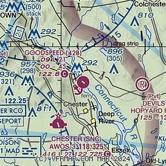
|
| Airport distance calculator |
|---|
|
|
| Sunrise and sunset |
|---|
|
Times for 13-Mar-2026
| | Local
(UTC-4) | | Zulu
(UTC) |
|---|
| Morning civil twilight | | 06:38 | | 10:38 |
| Sunrise | | 07:06 | | 11:06 |
| Sunset | | 18:53 | | 22:53 |
| Evening civil twilight | | 19:20 | | 23:20 |
|
| Current date and time |
|---|
| Zulu (UTC) | 13-Mar-2026 07:51:28 |
|---|
| Local (UTC-4) | 13-Mar-2026 03:51:28 |
|---|
|
| METAR |
|---|
KSNC
4nm SW | 130735Z AUTO 00000G10KT 10SM FEW037 M00/M06 A2999 RMK AO2
|
KMMK
18nm W | 130653Z AUTO 31009KT 10SM SCT046 BKN060 01/M06 A3001 RMK AO2 SLP164 T00061056
|
KHFD
19nm NW | 130653Z AUTO VRB04KT 10SM CLR 01/M08 A3000 RMK AO2 SLP157 T00111083
|
KGON
19nm E | 130656Z AUTO 28005KT 10SM CLR 00/M08 A2999 RMK AO2 SLP154 T00001083
|
|
| TAF |
|---|
KGON
19nm E | 130539Z 1306/1406 29011G20KT P6SM SCT070 FM130700 29010KT P6SM SCT070 FM131100 21006KT P6SM FEW040 SCT120 FM131400 25010KT P6SM SCT040 SCT120 SCT200 FM131600 20013G16KT P6SM SCT060 SCT120 BKN200 FM131800 18013G22KT P6SM BKN060 BKN120 BKN200 FM132100 18016G27KT P6SM BKN060 BKN100 BKN200 FM140500 21014G23KT P6SM SCT060 SCT100 SCT200
|
|
| NOTAMs |
|---|
NOTAMs are issued by the DoD/FAA and will open in a separate window not controlled by AirNav.
|
|

