FAA INFORMATION EFFECTIVE 14 MAY 2026
Location
| FAA Identifier: | SNC |
| Lat/Long: | 41-23-01.3540N 072-30-20.8340W
41-23.022567N 072-30.347233W
41.3837094,-72.5057872
(estimated) |
| Elevation: | 416 ft. / 127 m (estimated) |
| Variation: | 13W (1980) |
| From city: | 3 miles SW of CHESTER, CT |
| Time zone: | UTC -4 (UTC -5 during Standard Time) |
| Zip code: | 06412 |
Airport Operations
| Airport use: | Open to the public |
| Activation date: | 06/1959 |
| Control tower: | no |
| ARTCC: | NEW YORK CENTER |
| FSS: | BRIDGEPORT FLIGHT SERVICE STATION |
| NOTAMs facility: | SNC (NOTAM-D service available) |
| Attendance: | APR-OCT 0900-2000, NOV-MAR 0900-1800 |
| Wind indicator: | lighted |
| Segmented circle: | no |
| Lights: | SS-SR |
| Beacon: | white-green (lighted land airport)
ROTG BCN OPRS 24/7. Operates sunset to sunrise. |
Airport Communications
| CTAF/UNICOM: | 122.725 |
| WX AWOS-3: | 118.325 (860-526-1551) |
| NEW YORK APPROACH: | 124.075 |
| NEW YORK DEPARTURE: | 124.075 |
| WX ASOS at MMK (16 nm NW): | 134.925 (203-639-9405) |
| WX ASOS at HVN (19 nm SW): | PHONE 203-466-6205 |
Nearby radio navigation aids
| VOR radial/distance | | VOR name | | Freq | | Var |
|---|
| MADr076/9.4 | | MADISON VOR/DME | | 110.40 | | 13W |
| HFDr186/15.6 | | HARTFORD VOR/DME | | 114.90 | | 13W |
| GONr293/20.7 | | GROTON VOR/DME | | 110.85 | | 14W |
| ORWr260/25.0 | | NORWICH VOR/DME | | 110.00 | | 14W |
| HTOr356/29.2 | | HAMPTON VORTAC | | 113.60 | | 13W |
| CCCr039/30.3 | | CALVERTON VOR/DME | | 114.55 | | 13W |
| BDRr076/30.9 | | BRIDGEPORT VOR/DME | | 108.80 | | 12W |
Airport Services
| Fuel available: | 100LL
100LL:SELF SVC FUEL AVBL WITH CREDIT CARD. |
| Parking: | hangars and tiedowns |
| Airframe service: | MAJOR |
| Powerplant service: | MAJOR |
| Bottled oxygen: | NONE |
| Bulk oxygen: | NONE |
Runway Information
Runway 17/35
| Dimensions: | 2722 x 50 ft. / 830 x 15 m |
| Surface: | asphalt, in fair condition |
| Weight bearing capacity: | |
| Runway edge lights: | medium intensity
NON-STD MIRL FIXTURES/CONES. |
| RUNWAY 17 | | RUNWAY 35 |
| Latitude: | 41-23.234300N | | 41-22.810833N |
| Longitude: | 072-30.444967W | | 072-30.249500W |
| Elevation: | 395.0 ft. | | 408.0 ft. |
| Traffic pattern: | left | | left |
| Runway heading: | 174 magnetic, 161 true | | 354 magnetic, 341 true |
| Displaced threshold: | 559 ft.
DSPLCD THR MARKED BUT NOT LGTD. | | no |
| Markings: | NSTD, in fair condition | | NSTD, in fair condition |
| Runway end identifier lights: | yes | | yes |
| Touchdown point: | yes, no lights | | yes, no lights |
| Obstructions: | 50 ft. tree, 207 ft. from runway, 66 ft. right of centerline, 1:1 slope to clear
+5 FT TREE 56 FT DSTC, 60 FT L. | | none
+3 FT BRUSH, 0 FT FM THR, 103 FT R. |
Airport Ownership and Management from official FAA records
| Ownership: | Privately-owned |
| Owner: | WHELEN AVIATION
WINTHROP ROAD
CHESTER, CT 06412
Phone 860-526-4321 |
| Manager: | CHARLES F. GREENEY, JR.
WHELEN ENGINEERING, 51 WINTHROP ROAD
CHESTER, CT 06412
Phone 860-718-2109
CELL 860-853-0993. |
Additional Remarks
| - | FOR CD CTC NEW YORK APCH AT 516-683-2449. |
| - | (DSPLCD THR APCH RATIO, RWY 17) DSPLCD THR 5 FT HYR THAN AER. |
Instrument Procedures
NOTE: All procedures below are presented as PDF files. If you need a reader for these files, you should download the free Adobe Reader.NOT FOR NAVIGATION. Please procure official charts for flight.
FAA instrument procedures published for use from 14 May 2026 at 0901Z to 11 June 2026 at 0900Z.
STARs - Standard Terminal Arrivals |
|---|
| SARDI ONE (RNAV) | |
2 pages:
[1] [2] (476KB) |
IAPs - Instrument Approach Procedures |
|---|
| RNAV (GPS) RWY 17 | |
download (200KB) |
| RNAV (GPS) RWY 35 | |
download (192KB) |
| NOTE: Special Alternate Minimums apply | |
download (134KB) |
| NOTE: Special Take-Off Minimums/Departure Procedures apply | |
download (178KB) |
Other nearby airports with instrument procedures:
KMMK - Meriden Markham Municipal Airport (16 nm NW)
KHVN - Tweed/New Haven Airport (19 nm SW)
KGON - Groton-New London Airport (21 nm E)
KHFD - Hartford-Brainard Airport (22 nm N)
0B8 - Elizabeth Field Airport (23 nm E)
|
|

Road maps at:
MapQuest
Bing
Google
| Aerial photo |
|---|
WARNING: Photo may not be current or correct
 Photo taken 21-Oct-2009
Do you have a better or more recent aerial photo of Chester Airport that you would like to share? If so, please send us your photo.
|
| Sectional chart |
|---|
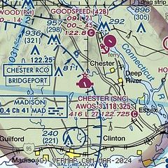
|
| Airport distance calculator |
|---|
|
|
| Sunrise and sunset |
|---|
|
Times for 25-May-2026
| | Local
(UTC-4) | | Zulu
(UTC) |
|---|
| Morning civil twilight | | 04:51 | | 08:51 |
| Sunrise | | 05:24 | | 09:24 |
| Sunset | | 20:10 | | 00:10 |
| Evening civil twilight | | 20:43 | | 00:43 |
|
| Current date and time |
|---|
| Zulu (UTC) | 25-May-2026 04:03:15 |
|---|
| Local (UTC-4) | 25-May-2026 00:03:15 |
|---|
|
| METAR |
|---|
| KSNC | 250355Z AUTO 00000KT 1/4SM FG OVC001 13/13 A3019 RMK AO2
|
KMMK
17nm NW | 250353Z AUTO 00000KT 8SM OVC006 13/13 A3020 RMK AO2 SLP226 T01330128
|
KHVN
18nm SW | 250353Z AUTO 04005KT 8SM OVC005 13/13 A3019 RMK AO2 RAB11E22 SLP222 P0001 T01330128 $
|
|
| TAF |
|---|
KGON
21nm E | 241933Z 2420/2518 08014G24KT 4SM RA BR OVC006 FM242200 08012KT 2SM -RA BR OVC005 FM250000 06008KT 1SM -RA BR OVC004 FM250300 VRB05KT 1/2SM -DZ FG OVC003 FM251400 VRB05KT 1SM SHRA BR OVC006 PROB30 2514/2517 TSRA SCT007 BKN025CB FM251700 27006KT 5SM BR FEW007 BKN015
|
|
| NOTAMs |
|---|
NOTAMs are issued by the DoD/FAA and will open in a separate window not controlled by AirNav.
|
|

