FAA INFORMATION EFFECTIVE 09 JULY 2026
Location
| FAA Identifier: | HVN |
| Lat/Long: | 41-15-49.4090N 072-53-15.8250W
41-15.823483N 072-53.263750W
41.2637247,-72.8877292
(estimated) |
| Elevation: | 12.6 ft. / 3.8 m (surveyed) |
| Variation: | 13W (1980) |
| From city: | 3 miles SE of NEW HAVEN, CT |
| Time zone: | UTC -4 (UTC -5 during Standard Time) |
| Zip code: | 06512 |
Airport Operations
| Airport use: | Open to the public |
| Activation date: | 04/1940 |
| Control tower: | yes |
| ARTCC: | NEW YORK CENTER |
| FSS: | BRIDGEPORT FLIGHT SERVICE STATION |
| NOTAMs facility: | HVN (NOTAM-D service available) |
| Attendance: | 0600-2200
FUEL AVBL AFT HRS PPR 203-467-9555. |
| Pattern altitude: | 1011.6 ft. MSL
TPA: 999 FT AGL RECIPROCATING ENG, 1499 FT AGL TURBOPROP/JET. |
| Wind indicator: | lighted |
| Segmented circle: | yes |
| Lights: | WHEN ATCT CLSD ACTVT MALSF RWY 02; HIRL RWY 02/20 - CTAF. |
| Beacon: | white-green (lighted land airport)
Operates sunset to sunrise. |
| Landing fee: | yes, LDG FEE FOR ALL ACFT EXC MIL, GOVT, EMERG & MED. |
| Fire and rescue: | ARFF index C |
| Airline operations: | ARFF INDEX C SVCS PRVDD BTN 0600 AND 2359 DLY. ARFF INDEX B SVCS PRVDD DRG OTR TIMES. FOR INDEX C SVCS BTN 0000 AND 0559, 1HR 30MIN PPR AT 203-907-9818. |
| International operations: | customs landing rights airport |
Airport Communications
| CTAF: | 124.8 |
| UNICOM: | 122.95 |
| ATIS: | 133.65 |
| WX ASOS: | PHONE 203-466-6205 |
| NEW HAVEN GROUND: | 121.7 [0600-2200] |
| NEW HAVEN TOWER: | 124.8 [0600-2200] |
| NEW YORK APPROACH: | 124.075 |
| NEW YORK DEPARTURE: | 124.075 |
| CLEARANCE DELIVERY: | 121.7 121.7 ;WHEN HVN TWR CLSD |
| DENNA STAR: | 124.075 |
| WX ASOS at BDR (12 nm SW): | 119.15 (203-381-9453) |
| WX ASOS at MMK (15 nm N): | 134.925 (203-639-9405) |
| WX AWOS-3PT at OXC (17 nm NW): | 132.975 (203-262-1190) |
| WX AWOS-3 at SNC (19 nm NE): | 118.325 (860-526-1551) |
Nearby radio navigation aids
| VOR radial/distance | | VOR name | | Freq | | Var |
|---|
| MADr264/9.3 | | MADISON VOR/DME | | 110.40 | | 13W |
| BDRr072/12.3 | | BRIDGEPORT VOR/DME | | 108.80 | | 12W |
| CCCr002/20.4 | | CALVERTON VOR/DME | | 114.55 | | 13W |
| HFDr227/27.3 | | HARTFORD VOR/DME | | 114.90 | | 13W |
| CMKr104/31.3 | | CARMEL VOR/DME | | 116.60 | | 12W |
| HTOr322/33.1 | | HAMPTON VORTAC | | 113.60 | | 13W |
| DPKr046/34.0 | | DEER PARK VOR/DME | | 117.70 | | 12W |
| GONr278/37.9 | | GROTON VOR/DME | | 110.85 | | 14W |
Airport Services
| Fuel available: | 100LL JET-A |
| Parking: | hangars and tiedowns |
| Airframe service: | MAJOR |
| Powerplant service: | MAJOR |
| Bottled oxygen: | HIGH |
| Bulk oxygen: | HIGH |
Runway Information
Runway 2/20
| Dimensions: | 5600 x 150 ft. / 1707 x 46 m |
| Surface: | asphalt/grooved, in excellent condition |
| Weight bearing capacity: | | Single wheel: | 110.0 | | Double wheel: | 160.0 |
|
| Runway edge lights: | high intensity |
| RUNWAY 2 | | RUNWAY 20 |
| Latitude: | 41-15.363000N | | 41-16.283972N |
| Longitude: | 072-53.294755W | | 072-53.232737W |
| Elevation: | 6.5 ft. | | 12.6 ft. |
| Traffic pattern: | left | | left |
| Runway heading: | 016 magnetic, 003 true | | 196 magnetic, 183 true |
| Declared distances: | TORA:5600 TODA:5600 ASDA:5600 LDA:5600 | | TORA:5600 TODA:5600 ASDA:5600 LDA:5600 |
| Markings: | precision, in good condition | | nonprecision, in good condition |
| Visual slope indicator: | 4-light PAPI on left (3.00 degrees glide path) | | 4-light PAPI on left (3.50 degrees glide path) |
| RVR equipment: | touchdown | | rollout |
| Approach lights: | MALSF: 1,400 foot medium intensity approach lighting system with sequenced flashers | | |
| Touchdown point: | yes, no lights | | yes, no lights |
| Instrument approach: | ILS/DME | | |
| Obstructions: | 36 ft. trees, 1400 ft. from runway, 33:1 slope to clear | | 55 ft. trees, 1300 ft. from runway, 20:1 slope to clear |
Airport Ownership and Management from official FAA records
| Ownership: | Publicly-owned |
| Owner: | CITY OF NEW HAVEN
155 BURR ST
NEW HAVEN, CT 06510
Phone 203-466-8833 |
| Manager: | JEREMY NIELSON
155 BURR ST
NEW HAVEN, CT 06512
Phone 203-466-8833 |
Additional Remarks
| A39-02/20 | PCR VALUE: 320/F/B/X/T |
| - | NOISE ABATEMENT PROCS IN EFCT. DEPARTING RWY 20, RIGHT AND LEFT TURN MADE ONLY AFT PASSING SHORELINE. |
| - | WILDLIFE FQTLY ON OR INVOF ARPT. |
| - | TSNT PRKG ON EAST RAMP ONLY. |
| - | PAEW ADJ TO ALL OPR SFCS DALGT HRS APR-OCT. |
| - | LDG HELS USE TWYS A & H INTXN. |
| - | STANDING WATER AT INTXN OF TWY D & C AFT HVY RAIN. |
| - | FOR CD WHEN TWR CLSD CTC NEW YORK APCH AT 516-683-2449 OR 121.7. |
| - | TGL OPNS PMTD 0700-2200 MON-SAT; 0800-2200 SUN. |
| - | AVOID CLOSE-IN BASE LEGS AND SHORT APCHS LDG RWY 20. |
| - | FLT NOTIFICATION SVC (ADCUS) AVBL. |
| - | CLSD TO ACFT OVER 78 DB 0700-2200; 73 DB 2200-0000 & 0600-0700; 68 DB 0000-0600 EXCP MIL EMERG & MED ACFT; PPR CALL 203-907-9818. |
| - | EXTSV HOP SFC-10000 FT WI 20 MI NNW. |
Instrument Procedures
NOTE: All procedures below are presented as PDF files. If you need a reader for these files, you should download the free Adobe Reader.NOT FOR NAVIGATION. Please procure official charts for flight.
FAA instrument procedures published for use from 09 July 2026 at 0901Z to 06 August 2026 at 0900Z.
STARs - Standard Terminal Arrivals |
|---|
| DENNA ONE (RNAV) **NEW** | |
download (149KB) |
| SARDI ONE (RNAV) **NEW** | |
2 pages:
[1] [2] (474KB) |
IAPs - Instrument Approach Procedures |
|---|
| ILS OR LOC RWY 02 | |
download (229KB) |
| RNAV (GPS) RWY 02 | |
download (261KB) |
| RNAV (GPS) RWY 20 | |
download (207KB) |
| NOTE: Special Alternate Minimums apply | |
download (152KB) |
Departure Procedures |
|---|
| BRIDGEHAVEN ONE | |
download (215KB) |
| NOTE: Special Take-Off Minimums/Departure Procedures apply | |
download (510KB) |
Other nearby airports with instrument procedures:
KBDR - Bridgeport/Sikorsky Airport (12 nm SW)
KMMK - Meriden Markham Municipal Airport (15 nm N)
KOXC - Waterbury-Oxford Airport (17 nm NW)
KSNC - Chester Airport (19 nm NE)
4B8 - Robertson Field Airport (26 nm N)
|
|

Road maps at:
MapQuest
Bing
Google
| Aerial photo |
|---|
WARNING: Photo may not be current or correct
 Photo by Brian Walach
Taken in June 2020
From the northeast
Photo by Brian Walach
Taken in June 2020
From the northeast
Do you have a better or more recent aerial photo of Tweed/New Haven Airport that you would like to share? If so, please send us your photo.
|
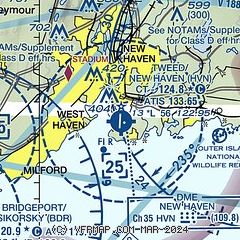
| Sectional chart |
|---|
|
 Download PDF
of official airport diagram from the FAA
| Airport distance calculator |
|---|
|
|
| Sunrise and sunset |
|---|
|
Times for 19-Jul-2026
| | Local
(UTC-4) | | Zulu
(UTC) |
|---|
| Morning civil twilight | | 05:03 | | 09:03 |
| Sunrise | | 05:36 | | 09:36 |
| Sunset | | 20:20 | | 00:20 |
| Evening civil twilight | | 20:52 | | 00:52 |
|
| Current date and time |
|---|
| Zulu (UTC) | 19-Jul-2026 09:27:43 |
|---|
| Local (UTC-4) | 19-Jul-2026 05:27:43 |
|---|
|
| METAR |
|---|
| KHVN | 182229Z 14006KT 1 1/2SM R02/4500VP6000FT VCTS RA BR OVC008 22/21 A2974 RMK AO2 LTG DSNT NE AND SW RAB09 TSB06E21 P0007 T02170211 $
|
KBDR
13nm SW | 190852Z AUTO 27007KT 8SM CLR 22/21 A2965 RMK AO2 SLP041 T02220206 53019 $
|
KMMK
15nm N | 190853Z AUTO 32005KT 10SM CLR 21/19 A2964 RMK AO2 SLP037 T02060194 53014
|
KOXC
16nm NW | 190856Z AUTO 30008KT 10SM HZ CLR 19/19 A2969 RMK AO2 SLP059 P0003 60011 T01940189 53017 $
|
KSNC
19nm NE | 190915Z AUTO VRB06KT 10SM CLR 21/21 A2966 RMK AO2
|
|
| TAF |
|---|
KBDR
13nm SW | 190523Z 1906/2006 VRB04KT 5SM BR BKN007 FM191000 32007KT P6SM SCT040 SCT250 FM191200 32012KT P6SM SCT250 TEMPO 1913/1917 32013G21KT FM191900 32010KT P6SM SCT250 FM200000 34005KT P6SM FEW250
|
|
| NOTAMs |
|---|
NOTAMs are issued by the DoD/FAA and will open in a separate window not controlled by AirNav.
|
|


