FAA INFORMATION EFFECTIVE 09 JULY 2026
Location
| FAA Identifier: | BDR |
| Lat/Long: | 41-09-48.5310N 073-07-34.2330W
41-09.808850N 073-07.570550W
41.1634808,-73.1261758
(estimated) |
| Elevation: | 8.5 ft. / 2.6 m (surveyed) |
| Variation: | 13W (1980) |
| From city: | 3 miles SE of BRIDGEPORT, CT |
| Time zone: | UTC -4 (UTC -5 during Standard Time) |
| Zip code: | 06615 |
Airport Operations
| Airport use: | Open to the public |
| Activation date: | 04/1940 |
| Control tower: | yes |
| ARTCC: | NEW YORK CENTER |
| FSS: | BRIDGEPORT FLIGHT SERVICE STATION |
| NOTAMs facility: | BDR (NOTAM-D service available) |
| Attendance: | 0600-2400 |
| Pattern altitude: | SNGL ENG ACFT 1000 FT AGL; ALL OTHERS 1500 FT AGL. |
| Wind indicator: | lighted |
| Segmented circle: | yes |
| Lights: | WHEN ATCT CLSD, ACTVT REIL RWY 06 & 24, 11 & 29; PAPI RWY 06, 11 & 29; HIRL RWY 06/24 & 11/29 - CTAF. |
| Beacon: | white-green (lighted land airport)
Operates sunset to sunrise. |
| Landing fee: | yes, PRKG FEE ALL ACFT AFT 2 HRS. LDG FEE ALL ACFT EXC SOLO STUDENTS. |
| Fire and rescue: | ARFF index A |
| International operations: | customs landing rights airport |
Airport Communications
| CTAF: | 120.9 |
| UNICOM: | 123.0 |
| ATIS: | 119.15 |
| WX ASOS: | 119.15 (203-381-9453) |
| BRIDGEPORT GROUND: | 121.75 257.8 [0630-2200] |
| BRIDGEPORT TOWER: | 120.9 257.8 [0630-2200] |
| NEW YORK APPROACH: | 124.075 |
| NEW YORK DEPARTURE: | 124.075 |
| CLEARANCE DELIVERY: | 121.75 124.075 ;WHEN BDR TWR CLSD |
| DENNA STAR: | 124.075 |
| WX ASOS at HVN (12 nm NE): | PHONE 203-466-6205 |
| WX AWOS-3PT at OXC (19 nm N): | 132.975 (203-262-1190) |
Nearby radio navigation aids
| VOR radial/distance | | VOR name | | Freq | | Var |
|---|
| BDR at field | | BRIDGEPORT VOR/DME | | 108.80 | | 12W |
| CCCr326/20.4 | | CALVERTON VOR/DME | | 114.55 | | 13W |
| MADr258/21.6 | | MADISON VOR/DME | | 110.40 | | 13W |
| CMKr121/21.7 | | CARMEL VOR/DME | | 116.60 | | 12W |
| DPKr032/23.7 | | DEER PARK VOR/DME | | 117.70 | | 12W |
| HFDr235/38.7 | | HARTFORD VOR/DME | | 114.90 | | 13W |
| HTOr305/39.5 | | HAMPTON VORTAC | | 113.60 | | 13W |
Airport Services
| Fuel available: | 100LL JET-A |
| Parking: | hangars and tiedowns |
| Airframe service: | MAJOR |
| Powerplant service: | MAJOR |
| Bottled oxygen: | HIGH/LOW |
Runway Information
Runway 11/29
| Dimensions: | 4759 x 150 ft. / 1451 x 46 m |
| Surface: | asphalt, in fair condition |
| Weight bearing capacity: | | Single wheel: | 30.0 | | Double wheel: | 108.0 |
|
| Runway edge lights: | high intensity |
| Operational restrictions: | RWY 11/29 NOT AVBL FOR PART 121/PART 380 OPS WITH SKED PAX CARRYING OPS MORE THAN 9 PAX SEATS AND NON-SKED PAX CARRYING OPS MORE THAN 30 PAX SEATS. 90 DAY PPR FOR UNSKED ACR OPS GTR THAN 30 PAX SEATS - CALL AMGR. |
| RUNWAY 11 | | RUNWAY 29 |
| Latitude: | 41-09.974342N | | 41-09.867470N |
| Longitude: | 073-08.097575W | | 073-07.070217W |
| Elevation: | 8.5 ft. | | 6.5 ft. |
| Traffic pattern: | left | | right |
| Runway heading: | 111 magnetic, 098 true | | 291 magnetic, 278 true |
| Displaced threshold: | no | | 364 ft. |
| Declared distances: | TORA:4759 TODA:4759 ASDA:4759 LDA:4759 | | TORA:4759 TODA:4759 ASDA:4759 LDA:4395 |
| Markings: | basic, in fair condition | | nonprecision, in fair condition |
| Visual slope indicator: | 4-light PAPI on right (3.50 degrees glide path) | | 4-light PAPI on left (3.00 degrees glide path) |
| Runway end identifier lights: | yes | | yes |
| Touchdown point: | yes, no lights | | yes, no lights |
| Obstructions: | 35 ft. trees, 500 ft. from runway, 120 ft. left of centerline, 8:1 slope to clear | | 15 ft. road, lighted, 200 ft. from runway
APCH RATIO 20:1 TO DTHR. |
Runway 6/24
| Dimensions: | 4677 x 100 ft. / 1426 x 30 m |
| Surface: | asphalt/grooved, in excellent condition |
| Weight bearing capacity: | | Single wheel: | 57.0 | | Double wheel: | 80.0 |
|
| Runway edge lights: | high intensity |
| Operational restrictions: | RWY 06/24 NOT AVBL FOR PART 121/PART 380 OPS WITH SKED PAX CARRYING OPS MORE THAN 9 PAX SEATS AND NON-SKED PAX CARRYING OPS MORE THAN 30 PAX SEATS. 90 DAY PPR FOR UNSKED ACR OPS GTR THAN 30 PAX SEATS - CALL AMGR. |
| RUNWAY 6 | | RUNWAY 24 |
| Latitude: | 41-09.422485N | | 41-09.967118N |
| Longitude: | 073-07.917247W | | 073-07.196678W |
| Elevation: | 6.9 ft. | | 6.7 ft. |
| Traffic pattern: | left | | left |
| Runway heading: | 058 magnetic, 045 true | | 238 magnetic, 225 true |
| Displaced threshold: | no | | 320 ft. |
| Declared distances: | TORA:4677 TODA:4677 ASDA:4677 LDA:4677 | | TORA:4677 TODA:4677 ASDA:4677 LDA:4357 |
| Markings: | precision, in good condition | | nonprecision, in good condition |
| Visual slope indicator: | 4-light PAPI on right (3.00 degrees glide path) | | 4-light PAPI on left (3.00 degrees glide path) |
| Runway end identifier lights: | yes | | yes |
| Touchdown point: | yes, no lights | | yes, no lights |
| Instrument approach: | ILS/DME | | |
| Obstructions: | 19 ft. road, 480 ft. from runway, 525 ft. left of centerline, 14:1 slope to clear | | 19 ft. road, lighted, 200 ft. from runway, 150 ft. left of centerline, 1:1 slope to clear
APCH RATIO 34:1 TO DTHR. |
Airport Ownership and Management from official FAA records
| Ownership: | Publicly-owned |
| Owner: | CITY OF BRIDGEPORT
45 LYON TERRACE
BRIDGEPORT, CT 06615
Phone 203-576-7201 |
| Manager: | LISA TRACHTENBURG
1000 GREAT MEADOW RD
STRATFORD, CT 06497
Phone 203-576-8163 |
Additional Remarks
| A39-11/29 | PCR VALUE: 278/F/B/X/U |
| A39-06/24 | PCR VALUE: 278/F/B/X/U |
| - | THERE MAY BE STANDING WATER ADJ TO ALL SFCS. |
| - | AVOID OVERFLYING RESL AREAS NE & SE OF ARPT. DEPARTING RWY 24 AVOID TURNS TIL 1/2 MILE BYD SHORELINE. |
| - | WHEN ATCT CLSD ALL ENG RUNUPS ARE PROHIBITED. HWVR, IF AN ACFT RQRS NIGHTTIME ENG MAINT, PPR FM AMGR IS RQRD AND RUNUPS ARE TO BE PERFORMED ON TWY G BTWN J & K. PILOTS ARE ADZD TO USE CARE PSNG THEIR ACFT TO PREVENT DMG FM PROP WASH TO AFLD SIGN. |
| - | UNEVEN SFCS RWY 29 SAFETY AREA APCH END LEFT SIDE. |
| - | POLE 120 FT .75 NM S OF ARPT UNLGTD. |
| - | RWY 29 CLSD TO TKOF ACFT MORE THAN 45000 LB EXC 30 MIN PPR 203-576-7497. |
| - | FOR CD WHEN ATCT CLSD CTC NEW YORK APCH AT 516-683-2449 OR 124.075 |
| - | EXTSV HOP BLW 10000 FT 5-15 MI NW THRU NE, FOR TFC INFO WHEN INVOF ARPT CTC SIKORSKY OPS ON 133.6/305.8 (0700-1630). |
| - | WHEN WINDS ARE LESS THAN 5 KTS RQSTD USE OF RWY 11 OR 29. |
| - | BIRDS & WILDLIFE FQTLY ON & INVOF ARPT. |
Instrument Procedures
NOTE: All procedures below are presented as PDF files. If you need a reader for these files, you should download the free Adobe Reader.NOT FOR NAVIGATION. Please procure official charts for flight.
FAA instrument procedures published for use from 09 July 2026 at 0901Z to 06 August 2026 at 0900Z.
STARs - Standard Terminal Arrivals |
|---|
| DENNA ONE (RNAV) **NEW** | |
download (149KB) |
| SARDI ONE (RNAV) **NEW** | |
2 pages:
[1] [2] (474KB) |
IAPs - Instrument Approach Procedures |
|---|
| ILS OR LOC RWY 06 | |
download (254KB) |
| RNAV (GPS) RWY 06 | |
download (201KB) |
| RNAV (GPS) RWY 24 | |
download (229KB) |
| RNAV (GPS) RWY 29 | |
download (201KB) |
| NOTE: Special Alternate Minimums apply | |
download (150KB) |
Departure Procedures |
|---|
| BRIDGEHAVEN ONE | |
download (235KB) |
| NOTE: Special Take-Off Minimums/Departure Procedures apply | |
download (532KB) |
Other nearby airports with instrument procedures:
KHVN - Tweed/New Haven Airport (12 nm NE)
KOXC - Waterbury-Oxford Airport (19 nm N)
KDXR - Danbury Municipal Airport (20 nm NW)
KISP - Long Island Mac Arthur Airport (22 nm S)
KHWV - Brookhaven Airport (24 nm SE)
|
|

Road maps at:
MapQuest
Bing
Google
| Aerial photo |
|---|
WARNING: Photo may not be current or correct
 Photo by David Newcomer
Photo taken 24-Feb-2020
from 8,000' altitude looking north.
Photo by David Newcomer
Photo taken 24-Feb-2020
from 8,000' altitude looking north.
Do you have a better or more recent aerial photo of Bridgeport/Sikorsky Airport that you would like to share? If so, please send us your photo.
|
| Sectional chart |
|---|
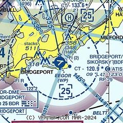
|
CAUTION: Diagram may not be current
 Download PDF
of official airport diagram from the FAA
| Airport distance calculator |
|---|
|
|
| Sunrise and sunset |
|---|
|
Times for 28-Jul-2026
| | Local
(UTC-4) | | Zulu
(UTC) |
|---|
| Morning civil twilight | | 05:14 | | 09:14 |
| Sunrise | | 05:45 | | 09:45 |
| Sunset | | 20:13 | | 00:13 |
| Evening civil twilight | | 20:44 | | 00:44 |
|
| Current date and time |
|---|
| Zulu (UTC) | 28-Jul-2026 10:28:35 |
|---|
| Local (UTC-4) | 28-Jul-2026 06:28:35 |
|---|
|
| METAR |
|---|
| KBDR | 281017Z 20006KT 7SM SCT007 23/22 A2975 RMK AO2 T02280217
|
KHVN
13nm NE | 280953Z 19005KT 5SM BKN007 OVC012 22/22 A2975
|
KOXC
18nm N | 280956Z AUTO 16005KT 1/4SM FG OVC002 20/20 A2978 RMK AO2 SLP089 T02000200 $
|
|
| TAF |
|---|
| KBDR | 280539Z 2806/2906 18007KT P6SM SCT060 SCT100 BKN250 FM281700 15010G17KT P6SM BKN040 OVC100 PROB30 2817/2823 3SM SHRA BR BKN025 FM282300 15010KT 5SM -SHRA SCT009 BKN015
|
|
| NOTAMs |
|---|
NOTAMs are issued by the DoD/FAA and will open in a separate window not controlled by AirNav.
|
|


