FAA INFORMATION EFFECTIVE 11 JUNE 2026
Location
| FAA Identifier: | HWV |
| Lat/Long: | 40-49-19.0350N 072-52-00.8660W
40-49.317250N 072-52.014433W
40.8219542,-72.8669072
(estimated) |
| Elevation: | 81.3 ft. / 24.8 m (surveyed) |
| Variation: | 14W (2000) |
| From city: | 1 mile N of SHIRLEY, NY |
| Time zone: | UTC -4 (UTC -5 during Standard Time) |
| Zip code: | 11967 |
Airport Operations
| Airport use: | Open to the public |
| Activation date: | 11/1943 |
| Control tower: | no |
| ARTCC: | NEW YORK CENTER |
| FSS: | NEW YORK FLIGHT SERVICE STATION |
| NOTAMs facility: | HWV (NOTAM-D service available) |
| Attendance: | 0700-1900 |
| Wind indicator: | lighted |
| Segmented circle: | yes |
| Lights: | ACTVT MALSR RWY 06; REIL RWYS 24, 15, & 33; PAPI RWYS 15 & 33; MIRL RWYS 06/24 & 15/33 - CTAF. |
| Beacon: | white-green (lighted land airport)
Operates sunset to sunrise. |
| Landing fee: | yes, LNDG FEES VARY. SEE ARPT WEBSITE FOR MORE INFO. |
Airport Communications
| CTAF/UNICOM: | 122.8 |
| WX ASOS: | 119.625 (631-399-7095) |
| NEW YORK APPROACH: | 120.05 |
| NEW YORK DEPARTURE: | 120.05 |
| CLEARANCE DELIVERY: | 133.2 |
| WX ASOS at ISP (11 nm W): | 120.725 (631-471-0131) |
| WX ASOS at FOK (11 nm E): | 119.925 (631-288-0588) |
Nearby radio navigation aids
| VOR radial/distance | | VOR name | | Freq | | Var |
|---|
| CCCr219/7.2 | | CALVERTON VOR/DME | | 114.55 | | 13W |
| DPKr097/19.9 | | DEER PARK VOR/DME | | 117.70 | | 12W |
| BDRr162/23.4 | | BRIDGEPORT VOR/DME | | 108.80 | | 12W |
| HTOr270/25.6 | | HAMPTON VORTAC | | 113.60 | | 13W |
| MADr208/30.6 | | MADISON VOR/DME | | 110.40 | | 13W |
Airport Services
| Fuel available: | 100LL JET-A |
| Parking: | hangars and tiedowns |
| Airframe service: | MAJOR |
| Powerplant service: | MAJOR |
| Bottled oxygen: | NONE |
| Bulk oxygen: | NONE |
Runway Information
Runway 15/33
| Dimensions: | 4222 x 150 ft. / 1287 x 46 m |
| Surface: | asphalt/concrete, in good condition |
| Weight bearing capacity: | | Single wheel: | 52.0 | | Double wheel: | 70.0 | | Double tandem: | 120.0 |
|
| Runway edge lights: | medium intensity |
| RUNWAY 15 | | RUNWAY 33 |
| Latitude: | 40-49.340610N | | 40-48.849030N |
| Longitude: | 072-52.299623W | | 072-51.652453W |
| Elevation: | 69.4 ft. | | 60.3 ft. |
| Traffic pattern: | left | | left |
| Runway heading: | 149 magnetic, 135 true | | 329 magnetic, 315 true |
| Markings: | nonprecision, in good condition | | nonprecision, in good condition |
| Visual slope indicator: | 2-light PAPI on left (3.00 degrees glide path) | | 2-light PAPI on left (3.00 degrees glide path) |
| Runway end identifier lights: | yes | | yes |
| Touchdown point: | yes, no lights | | yes, no lights |
| Obstructions: | 75 ft. trees, 1349 ft. from runway, 100 ft. left of centerline, 15:1 slope to clear | | 126 ft. trees, 1671 ft. from runway, 233 ft. left of centerline, 11:1 slope to clear |
Runway 6/24
| Dimensions: | 4201 x 100 ft. / 1280 x 30 m |
| Surface: | asphalt, in good condition |
| Weight bearing capacity: | | Single wheel: | 32.0 | | Double wheel: | 56.0 | | Double tandem: | 93.0 |
|
| Runway edge lights: | medium intensity |
| RUNWAY 6 | | RUNWAY 24 |
| Latitude: | 40-49.296165N | | 40-49.785383N |
| Longitude: | 072-52.375022W | | 072-51.731045W |
| Elevation: | 70.0 ft. | | 81.2 ft. |
| Traffic pattern: | left | | left |
| Runway heading: | 059 magnetic, 045 true | | 239 magnetic, 225 true |
| Markings: | precision, in fair condition | | basic, in fair condition |
| Visual slope indicator: | 4-box VASI on left (3.00 degrees glide path) | | |
| Approach lights: | MALSR: 1,400 foot medium intensity approach lighting system with runway alignment indicator lights | | |
| Runway end identifier lights: | no | | yes |
| Touchdown point: | yes, no lights | | yes, no lights |
| Instrument approach: | ILS | | |
| Obstructions: | 118 ft. trees, 1446 ft. from runway, 663 ft. right of centerline, 10:1 slope to clear | | 54 ft. trees, 302 ft. from runway, 332 ft. right of centerline, 1:1 slope to clear |
Airport Ownership and Management from official FAA records
| Ownership: | Publicly-owned |
| Owner: | TOWN OF BROOKHAVEN
135 DAWN DRIVE
SHIRLEY, NY 11967
Phone 631-451-5300 |
| Manager: | DAVID MORAN
135 DAWN DRIVE
SHIRLEY, NY 11967
Phone 631-451-6299
ALTN PHONE 631-451-6291 OR 631-451-6299. |
Additional Remarks
| - | GLIDER OPNS DALGT HOURS. |
| - | OVERNIGHT RAMP PARKING $5.00. |
| - | EXTENSIVE PARACHUTE JUMPING ACTIVITY INVOF ARPT. |
| - | ALL TWY LIGHTS OPR. |
| - | FOR CD CTC NEW YORK APCH AT 516-683-2449 OR 133.2 |
| - | TGL ON HOL, WKENDS & NON-DALGT HRS NOT RCMDD. |
| - | RELOCATED THRESHOLD IS TAXIWAY Z1 |
| - | DINER/LUNCHEONETTE OPN 7 DAYS/WEEK 0700-1600. |
| - | GLIDERS USE RIGHT TRAFFIC PATTERN FOR RYS 24 & 33; GLIDERS USE LEFT TRAFFIC PATTERN FOR RYS 06 & 15 |
| - | UPPER AIR OBSERVATION BALLOONS LAUNCHED 3 MI NORTH OF ARPT 0600 & 1800. |
| - | PILOTS BE AWARE WHEN CONDUCTING PRACTICE ILS APCHS: EXTENSIVE LIGHT ACFT TRAINING ON & INVOF ARPT ALL HRS. |
| - | DEER ALL AREAS OF ARPT ESPECIALLY AT NIGHT. |
Instrument Procedures
NOTE: All procedures below are presented as PDF files. If you need a reader for these files, you should download the free Adobe Reader.NOT FOR NAVIGATION. Please procure official charts for flight.
FAA instrument procedures published for use from 11 June 2026 at 0901Z to 09 July 2026 at 0900z.
STARs - Standard Terminal Arrivals |
|---|
| SARDI ONE (RNAV) **NEW** | |
2 pages:
[1] [2] (473KB) |
IAPs - Instrument Approach Procedures |
|---|
| ILS OR LOC RWY 06 | |
download (236KB) |
| RNAV (GPS) RWY 06 | |
download (288KB) |
| RNAV (GPS) RWY 15 | |
download (180KB) |
| RNAV (GPS) RWY 33 | |
download (181KB) |
| RNAV (GPS)-A | |
download (186KB) |
| VOR RWY 06 | |
download (193KB) |
| NOTE: Special Alternate Minimums apply | |
download (145KB) |
| NOTE: Special Take-Off Minimums/Departure Procedures apply | |
download (150KB) |
Other nearby airports with instrument procedures:
KISP - Long Island Mac Arthur Airport (11 nm W)
KFOK - Francis S Gabreski Airport (11 nm E)
87N - Southampton Heliport (18 nm E)
KBDR - Bridgeport/Sikorsky Airport (24 nm NW)
KFRG - Republic Airport (25 nm W)
|
|

Road maps at:
MapQuest
Bing
Google
| Aerial photo |
|---|
WARNING: Photo may not be current or correct
 Photo by David Newcomer
Photo taken 15-Jul-2009
from 3,500'.
Photo by David Newcomer
Photo taken 15-Jul-2009
from 3,500'.
Do you have a better or more recent aerial photo of Brookhaven Airport that you would like to share? If so, please send us your photo.
|
| Sectional chart |
|---|
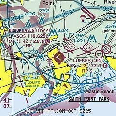
|
| Airport distance calculator |
|---|
|
|
| Sunrise and sunset |
|---|
|
Times for 13-Jun-2026
| | Local
(UTC-4) | | Zulu
(UTC) |
|---|
| Morning civil twilight | | 04:47 | | 08:47 |
| Sunrise | | 05:20 | | 09:20 |
| Sunset | | 20:23 | | 00:23 |
| Evening civil twilight | | 20:56 | | 00:56 |
|
| Current date and time |
|---|
| Zulu (UTC) | 13-Jun-2026 23:28:29 |
|---|
| Local (UTC-4) | 13-Jun-2026 19:28:29 |
|---|
|
| METAR |
|---|
| KHWV | 132256Z AUTO 22007KT 10SM CLR 27/16 A2986 RMK AO2 SLP112 T02670161 PWINO
|
KISP
11nm W | 132256Z 22009KT 10SM FEW070 FEW250 26/16 A2985 RMK AO2 SLP107 T02610161
|
KFOK
11nm E | 132253Z 22006KT 10SM CLR 27/16 A2987 RMK AO2 SLP116 T02670156
|
|
| TAF |
|---|
KISP
11nm W | 131938Z 1320/1418 24010KT P6SM SKC FM140100 24004KT P6SM FEW250 FM140600 VRB02KT P6SM FEW250 FM141400 20007KT P6SM SCT100
|
|
| NOTAMs |
|---|
NOTAMs are issued by the DoD/FAA and will open in a separate window not controlled by AirNav.
|
|


