FAA INFORMATION EFFECTIVE 14 MAY 2026
Location
| FAA Identifier: | FOK |
| Lat/Long: | 40-50-37.0270N 072-37-54.5230W
40-50.617117N 072-37.908717W
40.8436186,-72.6318119
(estimated) |
| Elevation: | 66.1 ft. / 20.1 m (surveyed) |
| Variation: | 13W (1980) |
| From city: | 3 miles N of WESTHAMPTON BEACH, NY |
| Time zone: | UTC -4 (UTC -5 during Standard Time) |
| Zip code: | 11978 |
Airport Operations
| Airport use: | Open to the public |
| Activation date: | 06/1943 |
| Control tower: | yes |
| ARTCC: | NEW YORK CENTER |
| FSS: | NEW YORK FLIGHT SERVICE STATION |
| NOTAMs facility: | FOK (NOTAM-D service available) |
| Attendance: | 0700-2300 |
| Wind indicator: | yes |
| Segmented circle: | no |
| Lights: | WHEN ATCT CLSD ACTVT MALSR RWY 24; REIL RWY 06, 15, & 33; PAPI RWY 06, 15 & 24; VASI RWY 33; HIRL RWY 06/24; MIRL RWY 15/33 - CTAF. |
| Beacon: | white-green (lighted land airport)
Operates sunset to sunrise. |
| Landing fee: | yes |
| International operations: | customs landing rights airport |
Airport Communications
| CTAF: | 125.3 |
| WX ASOS: | 119.925 (631-288-0588) |
| SUFFOLK GROUND: | 121.8 225.4 [0700-2300] |
| SUFFOLK TOWER: | 125.3 236.6 [0700-2300] |
| NEW YORK APPROACH: | 125.975 |
| NEW YORK DEPARTURE: | 125.975 |
| ANG OPS: | 328.475 |
| EMERG: | 121.5 |
| NELIE STAR: | 120.05 |
| WX ASOS at HWV (11 nm W): | 119.625 (631-399-7095) |
| WX AWOS-3PT at JPX (19 nm E): | 118.075 (631-537-2527) |
Nearby radio navigation aids
| VOR radial/distance | | VOR name | | Freq | | Var |
|---|
| CCCr137/9.2 | | CALVERTON VOR/DME | | 114.55 | | 13W |
| HTOr265/15.0 | | HAMPTON VORTAC | | 113.60 | | 13W |
| MADr187/28.3 | | MADISON VOR/DME | | 110.40 | | 13W |
| BDRr142/29.3 | | BRIDGEPORT VOR/DME | | 108.80 | | 12W |
| DPKr096/30.7 | | DEER PARK VOR/DME | | 117.70 | | 12W |
| GONr236/39.3 | | GROTON VOR/DME | | 110.85 | | 14W |
Airport Services
| Fuel available: | 100LL JET-A |
| Parking: | hangars and tiedowns |
| Airframe service: | MAJOR |
| Powerplant service: | MAJOR |
| Bottled oxygen: | HIGH/LOW |
| Bulk oxygen: | NONE |
Runway Information
Runway 6/24
| Dimensions: | 9002 x 150 ft. / 2744 x 46 m
RWY 06/24 1000 FT SAFETY AREA EACH END. |
| Surface: | asphalt/concrete, in good condition
6000 FT ASPH OVERLAY IN CNTR OF RWY. |
| Weight bearing capacity: | | PCN 31 /F/B/X/T | | Single wheel: | 100.0 | | Double wheel: | 120.0 | | Double tandem: | 200.0 |
|
| Runway edge lights: | high intensity |
| RUNWAY 6 | | RUNWAY 24 |
| Latitude: | 40-50.174383N | | 40-51.267195N |
| Longitude: | 072-38.340822W | | 072-37.021667W |
| Elevation: | 47.5 ft. | | 66.1 ft. |
| Traffic pattern: | left | | right |
| Runway heading: | 056 magnetic, 043 true | | 236 magnetic, 223 true |
| Markings: | precision, in good condition | | precision, in good condition |
| Visual slope indicator: | 2-light PAPI on left (3.00 degrees glide path) | | 4-light PAPI on left (3.00 degrees glide path) |
| Approach lights: | | | MALSR: 1,400 foot medium intensity approach lighting system with runway alignment indicator lights |
| Runway end identifier lights: | yes | | |
| Touchdown point: | yes, no lights | | yes, no lights |
| Instrument approach: | | | ILS/DME |
| Obstructions: | 85 ft. trees, 1776 ft. from runway, 278 ft. left of centerline, 18:1 slope to clear
+30 FT TREES, 135-285 FT FM RWY END, 357-530 FT RIGHT; +50 FT STRUCTURE, 1500 FT FM RWY, 78 FT RIGHT. | | 70 ft. trees, 1086 ft. from runway, 620 ft. left of centerline, 12:1 slope to clear
+85 FT TO 91 FT TREES, 2160 FT TO 2350 FT FM RWY, PERPENDICULAR TO EXTDD RWY CNTRLN. |
Runway 1/19
| Dimensions: | 5100 x 150 ft. / 1554 x 46 m
SOUTH END RWY 900 FT & NORTH END RWY 1000 FT ARE SAFETY AREAS. |
| Surface: | asphalt/concrete, in fair condition |
| Weight bearing capacity: | | PCN 17 /R/B/Y/T | | Single wheel: | 50.0 | | Double wheel: | 50.0 | | Double tandem: | 100.0 |
|
| RUNWAY 1 | | RUNWAY 19 |
| Latitude: | 40-50.078500N | | 40-50.917545N |
| Longitude: | 072-38.217400W | | 072-38.265652W |
| Elevation: | 46.3 ft. | | 64.2 ft. |
| Traffic pattern: | left | | left |
| Runway heading: | 010 magnetic, 357 true | | 190 magnetic, 177 true |
| Markings: | basic, in good condition | | basic, in good condition |
| Touchdown point: | yes, no lights | | yes, no lights |
| Obstructions: | 55 ft. trees, 1342 ft. from runway, 219 ft. left of centerline, 20:1 slope to clear
+40 FT TO 55 FT TREES, 1280 FT TO 1360 FT FM RWY, PERPENDICULAR TO EXTDD RWY CNTRLN. | | 49 ft. trees, 1014 ft. from runway, 329 ft. left of centerline, 16:1 slope to clear
+33 FT TO 47 FT TREES, 1000 FT TO 1080 FT FM RWY, PERPENDICULAR TO EXTDD RWY CNTRLN. |
Runway 15/33
| Dimensions: | 5002 x 150 ft. / 1525 x 46 m
RWY 15/33 1000 FT SAFETY AREA EACH END. |
| Surface: | asphalt, in good condition |
| Weight bearing capacity: | | PCN 42 /F/B/W/T | | Single wheel: | 94.0 | | Double wheel: | 157.0 | | Double tandem: | 259.0 |
|
| Runway edge lights: | medium intensity |
| Runway edge markings: | 15/33 MIL MAX EFFORT LDG STRIP MKGS (3500 X 60) INCLD WITH NPI RWY MKGS. |
| RUNWAY 15 | | RUNWAY 33 |
| Latitude: | 40-50.830120N | | 40-50.273600N |
| Longitude: | 072-38.378495W | | 072-37.578705W |
| Elevation: | 63.0 ft. | | 48.1 ft. |
| Traffic pattern: | left | | right |
| Runway heading: | 145 magnetic, 132 true | | 326 magnetic, 313 true |
| Markings: | nonprecision, in good condition | | nonprecision, in good condition |
| Visual slope indicator: | 2-light PAPI on left (3.00 degrees glide path) | | 4-box VASI on left (3.00 degrees glide path) |
| Runway end identifier lights: | yes | | yes |
| Touchdown point: | yes, no lights | | yes, no lights |
| Obstructions: | 58 ft. trees, 1067 ft. from runway, 153 ft. left of centerline, 14:1 slope to clear
+35 FT TO 52 FT TREES, 1112 FT TO 1141 FT FM RWY, PERPENDICULAR TO EXTDD RWY CNTRLN. | | 42 ft. trees, 1070 ft. from runway, 250 ft. left of centerline, 20:1 slope to clear
+30 FT TO 33 FT TREES, 1035 FT TO 1103 FT FM RWY, PERPENDICULAR TO EXTDD RWY CNTRLN. |
Airport Ownership and Management from official FAA records
| Ownership: | Publicly-owned |
| Owner: | COUNTY OF SUFFOLK
COUNTY CENTER
RIVERHEAD, NY 11901
Phone (631) 852-8095 |
| Manager: | JOSHUA SMITH
GABRESKI AIRPORT, ADMINISTRATION BLDG #1
WESTHAMPTON, NY 11978
Phone 631-852-8095 |
Additional Remarks
| - | OIL - O-148-156(MIL) SOAP. |
| - | RSTD - NO 180 DEG TURNS PMTD ON ASPH SECTION OF RWY 06/24. |
| - | CAUTION: BIRDS AND DEER HAZ. PJE VCNTY OF ARPT. |
| - | CSTMS/AG/IMG: US CSTMS CLNC SVC AVBL WITH PN (FRG) 631-753-2691 (MIL FLTS WILL COORD THRU BASE OPNS 631-723-7362/7364). MIN 24 HR PN ON RGLR BUS DAY PRECDNG SVC RQR DATE, MAX PAX 15. US CSTMS HRS BTN 0800 AND 2200 LOCAL. |
| - | CLASS D AIRSPACE EFF 1200-0400Z++; OT CLASS G. |
| - | MILITARY: ANG: PPR OFFL BUS. FOR USE OF ANG RAMP. OFFL BUS ONLY PPR ALL ACFT, 48 HR PN, CTC AFLD OPS DSN 456-7362, C631-723-7362 DRG DUTY HR. TUE-FRI PPR DRG OFF-DUTY HR. 106 OG/CC APVL REQUIRED NML DUTY HR. NML DUTY HR 1200-2130++ MON-FRI. CLSD SAT, SUN, HOL AND EV OTR MON. LTD RAMP SPACE. TRAN ACFT MAY BE DIVERTED TO CIV FBO DRG NON-DUTY HR. NON-STANDARD MARKINGS ON HH-60 APRON; WHITE PAINTED LINES DENOTING A ROADWAY ON THE APRON BY THE PODS INDICATING WHERE A VEHICLE MUST DRIVE IN ORDER TO MAINTAIN ALL NECESSARY WINGTIP CLEARANCES. |
| - | VOLUNTARY NOISE ABATEMENT PROCS IN EFCT; SEE ARPT WEBSITE. |
| - | ANG: ADVSY FOR TRAN AIRCREWS - WING TIP CLNC WAIVER IN EFFECT ON GUARD C-130 RAMP. |
| - | FUEL: A++ (MIL) AVBL. |
| - | BEARING STRENGTH RWY 01-19: S38 T49 |
| - | FOR CD WHEN ATCT CLSD CTC NEW YORK APCH AT 516-683-2449. |
| - | RCMDD RSVN WITH FBO PRIOR TO ARR. |
| - | WHEN SAFETY AND OPNS ALLOW, RWY 24 PREF FOR NOISE ABATEMENT. |
| - | BEARING STENGTH RWY 06-24: S100 DW120 DT 200. |
| - | BEARING STENGTH RWY 15-33: S94 DW157 DT259. |
| - | JASU: AVBL DUR ANG OPR HR. (A/M32A-86) 2(MA-1A). |
| - | FUEL: AVBL DUR ANG OPR HR. J8(MIL) (NC-100LL, A). |
| - | FLUID - SP DE-ICE LOX. |
Instrument Procedures
NOTE: All procedures below are presented as PDF files. If you need a reader for these files, you should download the free Adobe Reader.NOT FOR NAVIGATION. Please procure official charts for flight.
FAA instrument procedures published for use from 14 May 2026 at 0901Z to 11 June 2026 at 0900Z.
STARs - Standard Terminal Arrivals |
|---|
| NELIE FOUR (RNAV) | |
2 pages:
[1] [2] (244KB) |
| SARDI ONE (RNAV) | |
2 pages:
[1] [2] (476KB) |
IAPs - Instrument Approach Procedures |
|---|
| ILS OR LOC RWY 24 | |
download (288KB) |
| RNAV (GPS) RWY 06 | |
download (232KB) |
| RNAV (GPS) RWY 15 | |
download (213KB) |
| RNAV (GPS) RWY 24 | |
download (313KB) |
| RNAV (GPS) RWY 33 | |
download (218KB) |
| TACAN RWY 06 | |
download (241KB) |
| TACAN RWY 24 | |
download (256KB) |
| NOTE: Special Alternate Minimums apply | |
download (163KB) |
| NOTE: Special Take-Off Minimums/Departure Procedures apply | |
download (150KB) |
Other nearby airports with instrument procedures:
87N - Southampton Heliport (8 nm E)
KHWV - Brookhaven Airport (11 nm W)
KJPX - East Hampton Town Airport (19 nm E)
KISP - Long Island Mac Arthur Airport (21 nm W)
KHVN - Tweed/New Haven Airport (28 nm NW)
|
|

Road maps at:
MapQuest
Bing
Google
| Aerial photo |
|---|
WARNING: Photo may not be current or correct
 Photo courtesy of AirNav, LLC
Photo taken 02-Mar-2017
looking east.
Photo courtesy of AirNav, LLC
Photo taken 02-Mar-2017
looking east.
Do you have a better or more recent aerial photo of Francis S Gabreski Airport that you would like to share? If so, please send us your photo.
|
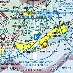
| Sectional chart |
|---|
|
CAUTION: Diagram may not be current
 Download PDF
of official airport diagram from the FAA
| Airport distance calculator |
|---|
|
|
| Sunrise and sunset |
|---|
|
Times for 25-May-2026
| | Local
(UTC-4) | | Zulu
(UTC) |
|---|
| Morning civil twilight | | 04:54 | | 08:54 |
| Sunrise | | 05:26 | | 09:26 |
| Sunset | | 20:09 | | 00:09 |
| Evening civil twilight | | 20:41 | | 00:41 |
|
| Current date and time |
|---|
| Zulu (UTC) | 25-May-2026 22:14:56 |
|---|
| Local (UTC-4) | 25-May-2026 18:14:56 |
|---|
|
| METAR |
|---|
| KFOK | 252153Z 20004KT 10SM CLR 19/16 A3004 RMK AO2 SLP173 T01940161 $
|
KHWV
11nm W | 252156Z AUTO 18006KT 10SM CLR 21/17 A3004 RMK AO2 SLP172 T02060167 PWINO
|
KJPX
19nm E | 252155Z AUTO 26005KT 10SM CLR 21/15 A3002 RMK AO2 T02050145
|
|
| TAF |
|---|
KISP
21nm W | 251936Z 2520/2618 22006KT P6SM BKN015 FM252100 23008KT P6SM SCT025 BKN250 FM260100 VRB05KT P6SM BKN250 FM260700 VRB05KT 5SM BR BKN250 TEMPO 2609/2612 3SM BR FM261200 03005KT P6SM BKN250 FM261700 20008KT P6SM BKN250
|
|
| NOTAMs |
|---|
NOTAMs are issued by the DoD/FAA and will open in a separate window not controlled by AirNav.
|
|


