FAA INFORMATION EFFECTIVE 11 JUNE 2026
Location
| FAA Identifier: | IJD |
| Lat/Long: | 41-44-38.5000N 072-10-48.8000W
41-44.641667N 072-10.813333W
41.7440278,-72.1802222
(estimated) |
| Elevation: | 246.1 ft. / 75.0 m (surveyed) |
| Variation: | 15W (1985) |
| From city: | 3 miles NE of WILLIMANTIC, CT |
| Time zone: | UTC -4 (UTC -5 during Standard Time) |
| Zip code: | 06256 |
Airport Operations
| Airport use: | Open to the public |
| Activation date: | 04/1940 |
| Control tower: | no |
| ARTCC: | BOSTON CENTER |
| FSS: | BRIDGEPORT FLIGHT SERVICE STATION |
| NOTAMs facility: | IJD (NOTAM-D service available) |
| Attendance: | UNATTENDED |
| Wind indicator: | yes |
| Segmented circle: | yes |
| Lights: | ACTVT REIL RWY 27; MIRL RWY 09/27- CTAF. |
| Beacon: | white-green (lighted land airport)
Operates sunset to sunrise. |
| Landing fee: | no, LDG FEE FOR BUS/CORPORATE ACFT. |
Airport Communications
| CTAF/UNICOM: | 122.975 |
| WX ASOS: | 133.675 (860-456-8839) |
| BRADLEY APPROACH: | 127.8 |
| BRADLEY DEPARTURE: | 127.8 |
| CLEARANCE DELIVERY: | 128.6 |
| WX AWOS-3 at LZD (13 nm E): | 119.125 (860-779-7251) |
- APCH SVC PRVDD BY BOSTON ARTCC ON FREQS 124.85/307.9 (WOODSTOCK RCAG) WHEN PROVIDENCE APCH CTL CLSD.
- NOTE: BRADLEY PRVDS DEP SVC 24 HRS DAILY.
Nearby radio navigation aids
| VOR radial/distance | | VOR name | | Freq | | Var |
|---|
| ORWr338/13.9 | | NORWICH VOR/DME | | 110.00 | | 14W |
| HFDr082/17.6 | | HARTFORD VOR/DME | | 114.90 | | 13W |
| PUTr244/19.7 | | PUTNAM VOR/DME | | 117.40 | | 14W |
| GONr001/25.5 | | GROTON VOR/DME | | 110.85 | | 14W |
| PVDr286/33.6 | | PROVIDENCE VOR/DME | | 115.60 | | 14W |
| MADr055/34.6 | | MADISON VOR/DME | | 110.40 | | 13W |
| BAFr150/34.7 | | BARNES VORTAC | | 113.00 | | 14W |
Airport Services
| Fuel available: | 100LL JET-A+
100LL:SELF SVC FUEL, CREDIT CARD ONLY: VISA, MASTERCARD & DISCOVER.
A+:SELF SVC FUEL, CREDIT CARD ONLY: VISA, MASTERCARD & DISCOVER. JET A HAS OVR WING & SNGL POINT NOZZLES. |
| Parking: | tiedowns |
| Airframe service: | MAJOR |
| Powerplant service: | MAJOR |
| Bottled oxygen: | NONE |
| Bulk oxygen: | NONE |
Runway Information
Runway 9/27
| Dimensions: | 4271 x 100 ft. / 1302 x 30 m |
| Surface: | asphalt, in good condition |
| Weight bearing capacity: | |
| Runway edge lights: | medium intensity |
| RUNWAY 9 | | RUNWAY 27 |
| Latitude: | 41-44.604692N | | 41-44.793353N |
| Longitude: | 072-11.109913W | | 072-10.205417W |
| Elevation: | 239.1 ft. | | 239.1 ft. |
| Traffic pattern: | left | | left |
| Runway heading: | 089 magnetic, 074 true | | 269 magnetic, 254 true |
| Displaced threshold: | 258 ft. | | no |
| Markings: | nonprecision, in fair condition | | nonprecision, in fair condition |
| Runway end identifier lights: | no | | yes |
| Touchdown point: | yes, no lights | | yes, no lights |
| Instrument approach: | | | LOC/DME |
| Obstructions: | 53 ft. trees, 210 ft. from runway, 220 ft. left of centerline
APCH RATIO 25:1 TO DTHR. | | 36 ft. tree, 415 ft. from runway, 255 ft. left of centerline, 5:1 slope to clear |
Runway 18/36
| Dimensions: | 2799 x 75 ft. / 853 x 23 m |
| Surface: | asphalt, in good condition |
| Weight bearing capacity: | |
| RUNWAY 18 | | RUNWAY 36 |
| Latitude: | 41-44.776867N | | 41-44.335235N |
| Longitude: | 072-11.139923W | | 072-10.964180W |
| Elevation: | 234.8 ft. | | 245.9 ft. |
| Traffic pattern: | left | | left |
| Runway heading: | 178 magnetic, 163 true | | 358 magnetic, 343 true |
| Displaced threshold: | no | | 799 ft. |
| Markings: | basic, in good condition | | basic, in good condition |
| Runway end identifier lights: | no | | no |
| Touchdown point: | yes, no lights | | yes, no lights |
| Obstructions: | 46 ft. trees, 800 ft. from runway, 200 ft. right of centerline, 13:1 slope to clear | | 60 ft. trees, 800 ft. from runway, 50 ft. left of centerline, 10:1 slope to clear
APCH RATIO 20:1 TO DTHR. |
Airport Ownership and Management from official FAA records
| Ownership: | Publicly-owned |
| Owner: | CONNECTICUT AIRPORT AUTHORITY
SUITE 160, 334 ELLA GRASSO TURNPIKE
WINDSOR LOCKS, CT 06096
Phone 860-292-2000 |
| Manager: | ROBERT PELLIGRINO
CONNECTICUT AIRPORT AUTHORITY, 239 MAXIM RD
HARTFORD, CT 06114
Phone 860-982-2443 |
Additional Remarks
| - | 4 OBS LGTS ON SRNDG HILLS OTS INDEFLY. |
| - | BIRDS ON & INVOF ARPT. |
| - | FOR CD CTC BRADLEY APCH AT 860-386-3597. |
| - | GLDR ACT ON & INVOF ARPT APR-NOV. |
Instrument Procedures
NOTE: All procedures below are presented as PDF files. If you need a reader for these files, you should download the free Adobe Reader.NOT FOR NAVIGATION. Please procure official charts for flight.
FAA instrument procedures published for use from 11 June 2026 at 0901Z to 09 July 2026 at 0900z.
IAPs - Instrument Approach Procedures |
|---|
| RNAV (GPS) RWY 09 | |
download (225KB) |
| RNAV (GPS) RWY 27 | |
download (215KB) |
| VOR-A | |
download (176KB) |
| NOTE: Special Alternate Minimums apply | |
download (128KB) |
| NOTE: Special Take-Off Minimums/Departure Procedures apply | |
download |
Other nearby airports with instrument procedures:
KLZD - Danielson Airport (13 nm E)
KHFD - Hartford-Brainard Airport (21 nm W)
3B0 - Southbridge Municipal Airport (22 nm N)
KBDL - Bradley International Airport (25 nm NW)
KGON - Groton-New London Airport (26 nm S)
|
|

Road maps at:
MapQuest
Bing
Google
| Aerial photo |
|---|
WARNING: Photo may not be current or correct
 Photo taken 19-Aug-2011
looking northeast.
Photo taken 19-Aug-2011
looking northeast.
Do you have a better or more recent aerial photo of Windham Airport that you would like to share? If so, please send us your photo.
|
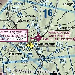
| Sectional chart |
|---|
|
CAUTION: Diagram may not be current

| Airport distance calculator |
|---|
|
|
| Sunrise and sunset |
|---|
|
Times for 14-Jun-2026
| | Local
(UTC-4) | | Zulu
(UTC) |
|---|
| Morning civil twilight | | 04:40 | | 08:40 |
| Sunrise | | 05:14 | | 09:14 |
| Sunset | | 20:24 | | 00:24 |
| Evening civil twilight | | 20:58 | | 00:58 |
|
| Current date and time |
|---|
| Zulu (UTC) | 14-Jun-2026 21:46:49 |
|---|
| Local (UTC-4) | 14-Jun-2026 17:46:49 |
|---|
|
| METAR |
|---|
| KIJD | 142052Z AUTO 19012G21KT 10SM CLR 28/14 A2977 RMK AO2 SLP079 T02780144 56017
|
|
| TAF |
|---|
KBDL
25nm NW | 141720Z 1418/1524 20013G25KT P6SM SCT120 BKN250 FM150400 19011G19KT 6SM -SHRA BKN035 PROB30 1504/1507 4SM TSRA OVC025CB FM151000 31011G20KT P6SM SCT080
|
KGON
25nm S | 141724Z 1418/1518 19010KT P6SM FEW150 BKN200 FM150300 19009KT P6SM FEW050 BKN100 TEMPO 1504/1506 4SM SHRA BR BKN007 OVC012 FM150600 22005KT 5SM -SHRA BR OVC004 FM151000 24006KT 3SM BR VCSH BKN005 OVC010 FM151200 31009KT P6SM BKN008 OVC015 FM151300 33012KT P6SM SCT040
|
KCEF
31nm NW | 141700Z 1417/1523 21010G15KT 9999 FEW050 BKN150 BKN250 510103 QNH2963INS TEMPO 1418/1501 22015G25KT 520004 BECMG 1500/1501 21010G15KT 9999 FEW050 BKN120 OVC250 WS020/23038KT QNH2960INS BECMG 1503/1504 21009KT 8000 -SHRA BKN035 BKN060 OVC100 WS020/23038KT QNH2947INS BECMG 1508/1509 31010G15KT 9999 NSW BKN045 BKN080 QNH2949INS TEMPO 1512/1516 32015G25KT 520004 BECMG 1515/1516 32010G15KT 9999 SCT060 BKN250 QNH2954INS TX33/1420Z TN18/1509Z
|
|
| NOTAMs |
|---|
NOTAMs are issued by the DoD/FAA and will open in a separate window not controlled by AirNav.
|
|


