FAA INFORMATION EFFECTIVE 19 MARCH 2026
Location
| FAA Identifier: | BDL |
| Lat/Long: | 41-56-20.5160N 072-41-03.5370W
41-56.341933N 072-41.058950W
41.9390322,-72.6843158
(estimated) |
| Elevation: | 173.3 ft. / 52.8 m (surveyed) |
| Variation: | 14W (1980) |
| From city: | 3 miles W of WINDSOR LOCKS, CT |
| Time zone: | UTC -4 (UTC -5 during Standard Time) |
| Zip code: | 06096 |
Airport Operations
| Airport use: | Open to the public |
| Activation date: | 07/1942 |
| Control tower: | yes |
| ARTCC: | BOSTON CENTER |
| FSS: | BRIDGEPORT FLIGHT SERVICE STATION |
| NOTAMs facility: | BDL (NOTAM-D service available) |
| Attendance: | CONTINUOUS |
| Pattern altitude: | 1700 FT AGL HVY ACFT. |
| Wind indicator: | lighted |
| Segmented circle: | no |
| Lights: | SS-SR |
| Beacon: | white-green (lighted land airport)
Operates sunset to sunrise. |
| Landing fee: | no, LDG FEE FOR BUS/CORPORATE & REVENUE PRODUCING ACFT. |
| Fire and rescue: | ARFF index C |
| International operations: | customs landing rights airport
CUST BY PRIOR ARNGMT. |
Airport Communications
| UNICOM: | 122.95 |
| WX ASOS: | 118.15 (860-386-3480) |
| BRADLEY GROUND: | 121.9 348.6 |
| BRADLEY TOWER: | 120.3 351.8 |
| BRADLEY APPROACH: | 123.95 ;061-240 125.35 ;241-060 127.225 |
| BRADLEY DEPARTURE: | 123.95 ;061-240 125.35 ;241-060 |
| CLEARANCE DELIVERY: | 121.75 322.3 |
| ANG OPS: | 138.55 349.7 |
| CLASS C: | 123.95 ;061-240 125.35 ;241-060 127.225 |
| D-ATIS: | 118.15 |
| DEER PARK STAR: | 123.95 ;061-240 125.35 ;241-060 |
| EMERG: | 121.5 243.0 |
| IC: | 123.95 ;061-240 125.35 ;241-060 |
| NG OPS: | 123.45 243.9 41.9 |
| STELA STAR: | 125.35 |
| WX ASOS at HFD (12 nm S): | PHONE 860-952-9954 |
| WX ASOS at BAF (13 nm N): | 127.1 (413-568-2267) |
| WX AWOS-AV at CT71 (15 nm S): | 129.825 |
| WX AWOS-3PT at 4B8 (17 nm SW): | 119.175 (860-351-5362) |
- ASDE-X IN USE. OPERATE TRANSPONDERS WITH ALTITUDE REPORTING MODE AND ADS-B (IF EQUIPPED) ENABLED ON ALL AIRPORT SURFACES.
Nearby radio navigation aids
| VOR radial/distance | | VOR name | | Freq | | Var |
|---|
| BAFr188/13.5 | | BARNES VORTAC | | 113.00 | | 14W |
| HFDr354/18.9 | | HARTFORD VOR/DME | | 114.90 | | 13W |
| CTRr164/24.2 | | CHESTER VOR/DME | | 115.10 | | 13W |
| PUTr282/37.5 | | PUTNAM VOR/DME | | 117.40 | | 14W |
| MADr014/37.5 | | MADISON VOR/DME | | 110.40 | | 13W |
| ORWr321/38.3 | | NORWICH VOR/DME | | 110.00 | | 14W |
Airport Services
| Fuel available: | 100LL JET-A |
| Parking: | hangars and tiedowns |
| Airframe service: | MAJOR |
| Powerplant service: | MAJOR |
| Bottled oxygen: | HIGH/LOW |
| Bulk oxygen: | HIGH/LOW |
Runway Information
Runway 6/24
| Dimensions: | 9510 x 200 ft. / 2899 x 61 m
245 FT BY 200 FT BLAST PAD SW END. |
| Surface: | asphalt/grooved, in excellent condition |
| Weight bearing capacity: | | Single wheel: | 200.0 | | Double wheel: | 200.0 | | Double tandem: | 350.0 | | Dual double tandem: | 710.0 |
|
| Runway edge lights: | high intensity |
| RUNWAY 6 | | RUNWAY 24 |
| Latitude: | 41-55.920833N | | 41-57.039920N |
| Longitude: | 072-41.794808W | | 072-40.327828W |
| Elevation: | 173.0 ft. | | 160.9 ft. |
| Traffic pattern: | left | | left |
| Runway heading: | 058 magnetic, 044 true | | 238 magnetic, 224 true |
| Declared distances: | TORA:9509 TODA:9509 ASDA:9509 LDA:9509 | | TORA:9509 TODA:9509 ASDA:9509 LDA:9509 |
| Markings: | precision, in good condition | | precision, in good condition |
| Visual slope indicator: | 4-light PAPI on left (3.00 degrees glide path) | | 4-light PAPI on left (3.00 degrees glide path) |
| RVR equipment: | touchdown, midfield, rollout | | touchdown, midfield, rollout |
| Approach lights: | ALSF2: standard 2,400 foot high intensity approach lighting system with centerline sequenced flashers (category II or III) | | MALSR: 1,400 foot medium intensity approach lighting system with runway alignment indicator lights |
| Runway end identifier lights: | no | | no |
| Centerline lights: | yes | | yes |
| Touchdown point: | yes, lighted | | yes, lighted |
| Instrument approach: | ILS/DME | | ILS/DME |
| Obstructions: | 185 ft. trees, 7200 ft. from runway, 400 ft. right of centerline, 37:1 slope to clear | | 71 ft. trees, 3300 ft. from runway, 43:1 slope to clear |
Runway 15/33
| Dimensions: | 6847 x 150 ft. / 2087 x 46 m
100 FT BY 200 FT BLAST PAD SE END. |
| Surface: | asphalt/grooved, in excellent condition |
| Weight bearing capacity: | | Single wheel: | 200.0 | | Double wheel: | 200.0 | | Double tandem: | 350.0 |
|
| Runway edge lights: | high intensity |
| RUNWAY 15 | | RUNWAY 33 |
| Latitude: | 41-56.543757N | | 41-55.755397N |
| Longitude: | 072-41.595173W | | 072-40.515928W |
| Elevation: | 168.8 ft. | | 168.5 ft. |
| Traffic pattern: | left | | left |
| Runway heading: | 148 magnetic, 134 true | | 328 magnetic, 314 true |
| Declared distances: | TORA:6847 TODA:6847 ASDA:6847 LDA:6847 | | TORA:6847 TODA:6847 ASDA:6847 LDA:6847 |
| Markings: | nonprecision, in good condition | | precision, in good condition |
| Visual slope indicator: | 4-light PAPI on left (3.50 degrees glide path) | | 4-light PAPI on right (3.00 degrees glide path) |
| RVR equipment: | rollout | | touchdown |
| Approach lights: | | | MALSF: 1,400 foot medium intensity approach lighting system with sequenced flashers |
| Runway end identifier lights: | yes | | |
| Touchdown point: | yes, no lights | | yes, no lights |
| Instrument approach: | | | ILS/DME |
| Obstructions: | 75 ft. trees, 1700 ft. from runway, 20:1 slope to clear | | 44 ft. trees, 1700 ft. from runway, 430 ft. left of centerline, 34:1 slope to clear |
Airport Ownership and Management from official FAA records
| Ownership: | Publicly-owned |
| Owner: | CONNECTICUT AIRPORT AUTHORITY
AIRPORT ADMINISTRATION OFFICE, TERMINAL A, 3RD FLOOR
WINDSOR LOCKS, CT 06096-1022
Phone 860-627-3001 |
| Manager: | MICHAEL W. SHEA, CPA
BRADLEY INTL AIRPORT
WINDSOR LOCKS, CT 06096
Phone 860-292-2000 |
Additional Remarks
| A39-06/24 | PCR VALUE: 1100/F/B/X/T |
| A39-15/33 | PCR VALUE: 1100/F/B/X/T |
| E117 | CT ANG AND U.S. ARMY NG. |
| - | NMRS BIRDS FQTLY ON OR INVOF ARPT. |
| - | MILITARY: ANG: NSTD WINGTIP CLNC WHITE DASHED LINES SPANNING BHND FRONT AND BACK OF ACFT PRKG ROWS AND WHITE GND EQPT BOXES PAINTED ON ANG RAMP. |
| - | MILITARY: ANG - DSN 636-7519/7520. C860-292-4519/4520. |
| - | MILITARY: ANG: AFLD MGR DOES NOT ISSUE OR STORE COMSEC FOR TRAN CREWS. |
| - | OPS CTC AUTOVON 636-8385; COML 860-627-3001. |
| - | CAUTION: ANG RAMP MRK MAY NOT BE APPROPRIATE FOR LARGE ACFT: FLW MARSHALLERS INSTR. |
| - | PARL TWY OPS ON TWY C & TWY B RSTRD TO ACFT WITH WINGSPANS OF 171 FT OR LESS. |
| - | ACFT REQG US CUST SVCS MUST PARK ON THE CUST SPOT W/ THE NOSE OF THE ACFT FACING SW. CTC CUST AT 860-292-1314 WHEN PARKED. |
| - | MILITARY: RMK: BASH PHASE II INCRD BIRD ACTVTY SEP-OCT AND MAR-APR. |
| - | FUEL: A++ (MIL). |
| - | FIXED WING ACFT USE LOW IDLE FOR TAXI, NO ENGINE CHECKS OR POWER RUNS ALLOWED ON THE ARNG RAMP DUE TO POSSIBLE FOD HAZARD. |
| - | MILITARY: ANG: WHEN CKG ATIS, BIRDS IN VCY MAY INDC HEIGHTENED BIRD WATCH CONDITION (BWC). USAF ACFT CTC ANG AIRFIELD OPS ON UHF FOR CURRENT BWC & ANY ASSOCD RSTRNS. |
| - | TWY C BTN TWY B & TWY C4 ACFT TAX SPD RSTRN OF 8 KTS/10 MPH MAX FOR ACFT WITH WINGSPAN 214 FT OR GTR. |
| - | LGTD OBST ANT 36 FT AGL/205 FT MSL (RWY 24 ILS/GS ANT) 162 FT NW OF TWY C CNTRLN MARKING BTN TWY B & TWY C4. |
| - | MILITARY: ANG: OPR 1200-2030Z++ MON, TUE, FRI; 1200-0400++ WED, THU. 41.9 149.825 335.775 (HAVOC OPS). |
| - | RWY 6 DE-ICE PAD CLSD TO ACFT WITH WINGSPAN 171 FT OR GTR EXC WITH FOLLOW-ME ESCORT BY ARPT OPS. |
| - | NON-BASED DVRSN ACRS CTC ARPT OPS 860-627-3001 PRIOR TO DIVG & PRVD CO FLT OPS CTC INFO, ACFT TYPE, POB, INTL OR DOM FLT & GND OPS AGRMTS. ONLY 1 INTL ACR JETBRIDGE AVBL FOR PAX. |
| - | MILITARY: ANG: OG/CC WAIVER ON FILE FOR C-130H/J WITH OPR WT UP TO 155000 LB. ALL OTHER ACFT OVR ANG RAMP PCN RQR WAIVER FR OG/CC THRU AFLD MGMT. |
| - | TWY D CLSD BTN TWY S & TWY D1 TO ACFT WITH WINGSPAN IN EXCESS OF 170 FT. |
| - | MILITARY: ANG: OPR 1200-2030Z++ MON-FRI (SAT, SUN UNIT TRNG ASSEMBLY), CLSD HOL. |
| - | MILITARY: ANG: PPR V220-2356. |
| - | NO DE-ICING AVBL AT ANG. |
| - | NO TRNG FLTS, NO PLAS, NO TGLS BTN: 2300 - 0700 MON THRU SAT & 2300 - 1200 SUN. |
Instrument Procedures
NOTE: All procedures below are presented as PDF files. If you need a reader for these files, you should download the free Adobe Reader.NOT FOR NAVIGATION. Please procure official charts for flight.
FAA instrument procedures published for use from 19 March 2026 at 0901Z to 16 April 2026 at 0900Z.
STARs - Standard Terminal Arrivals |
|---|
| DEER PARK THREE | |
download (202KB) |
| STELA ONE (RNAV) | |
download (218KB) |
IAPs - Instrument Approach Procedures |
|---|
| ILS OR LOC RWY 06 **CHANGED** | |
download (267KB) |
| ILS OR LOC RWY 24 **CHANGED** | |
download (293KB) |
| ILS OR LOC RWY 33 **CHANGED** | |
download (277KB) |
| ILS RWY 06 (SA CAT I) **CHANGED** | |
download (247KB) |
| ILS RWY 24 (SA CAT I - II) **CHANGED** | |
download (266KB) |
| ILS RWY 06 (CAT II - III) **CHANGED** | |
download (254KB) |
| RNAV (RNP) Z RWY 06 **CHANGED** | |
download (256KB) |
| RNAV (RNP) Z RWY 24 **CHANGED** | |
download (238KB) |
| RNAV (GPS) RWY 15 **CHANGED** | |
download (246KB) |
| RNAV (GPS) RWY 33 **CHANGED** | |
download (247KB) |
| RNAV (GPS) Y RWY 06 **CHANGED** | |
download (237KB) |
| RNAV (GPS) Y RWY 24 **CHANGED** | |
download (228KB) |
| COPTER ILS OR LOC RWY 06 **CHANGED** | |
download (256KB) |
| NOTE: Special Alternate Minimums apply | |
download (129KB) |
Departure Procedures |
|---|
| BRADLEY SIX | |
download (226KB) |
| THUMB ONE (RNAV) | |
download (196KB) |
| NOTE: Special Take-Off Minimums/Departure Procedures apply | |
download (484KB) |
Other nearby airports with instrument procedures:
KHFD - Hartford-Brainard Airport (12 nm S)
KBAF - Westfield-Barnes Regional Airport (13 nm N)
KCEF - Westover Air Reserve Base/Metropolitan Airport (17 nm NE)
4B8 - Robertson Field Airport (17 nm SW)
7B2 - Northampton Airport (24 nm N)
|
|

Road maps at:
MapQuest
Bing
Google
| Aerial photo |
|---|
WARNING: Photo may not be current or correct
 Photo by Barry Turner
Photo taken 29-Sep-2007
from a Mooney at 6000 feet
Photo by Barry Turner
Photo taken 29-Sep-2007
from a Mooney at 6000 feet
Do you have a better or more recent aerial photo of Bradley International Airport that you would like to share? If so, please send us your photo.
|
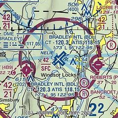
| Sectional chart |
|---|
|
CAUTION: Diagram may not be current
 Download PDF
of official airport diagram from the FAA
| Airport distance calculator |
|---|
|
|
| Sunrise and sunset |
|---|
|
Times for 31-Mar-2026
| | Local
(UTC-4) | | Zulu
(UTC) |
|---|
| Morning civil twilight | | 06:08 | | 10:08 |
| Sunrise | | 06:36 | | 10:36 |
| Sunset | | 19:14 | | 23:14 |
| Evening civil twilight | | 19:42 | | 23:42 |
|
| Current date and time |
|---|
| Zulu (UTC) | 01-Apr-2026 01:35:16 |
|---|
| Local (UTC-4) | 31-Mar-2026 21:35:16 |
|---|
|
| METAR |
|---|
| KBDL | 010051Z 19014G20KT 10SM BKN130 OVC240 19/11 A2986 RMK AO2 SLP110 T01890106
|
KHFD
12nm S | 010053Z 17010KT 10SM CLR 18/11 A2987 RMK AO2 SLP113 T01780106 $
|
KBAF
14nm N | 010053Z 16009KT 10SM CLR 20/11 A2984 RMK AO2 LTG DSNT N AND NW SLP104 T02000111
|
KCEF
17nm NE | 010055Z 20011KT 10SM SCT060 SCT120 BKN170 OVC250 20/11 A2981 RMK AO2A LTG DSNT W-N SLP098 T01970107
|
|
| TAF |
|---|
| KBDL | 312010Z 3120/0124 25010KT P6SM BKN090 PROB30 3123/0103 4SM -RA OVC025 FM010400 18007KT P6SM BKN110 FM010600 20007KT P6SM BKN100 WS020/23040KT PROB30 0106/0112 4SM -RA OVC025 FM011400 26008KT P6SM BKN030
|
KBAF
14nm N | 312000Z 3120/0202 23010G20KT 9999 BKN020 OVC030 520106 QNH2981INS TEMPO 0101/0104 4800 -TSRA OVC020CB BECMG 0114/0115 30010G20KT 9999 BKN025 510102 530306 QNH2996INS BECMG 0122/0123 36010G15KT 9999 BKN035 510102 530306 QNH3019INS TX25/3121Z TN16/0110Z
|
KCEF
17nm NE | 010010Z 0100/0206 21010G15KT 9999 VCTS BKN040CB BKN100 OVC200 QNH2977INS TEMPO 0100/0101 23015G25KT 3200 -TSRA OVC025CB BECMG 0101/0102 21009KT 6000 -SHRA BKN020 OVC080 WS020/24035KT QNH2973INS BECMG 0110/0111 23009KT 4800 BR SCT007 OVC015 QNH2979INS BECMG 0114/0115 31012KT 9999 NSW BKN045 BKN090 BKN150 510105 QNH2987INS TEMPO 0116/0123 33012G20KT 520006 BECMG 0200/0201 01009KT 6000 -RA SCT050 BKN080 OVC120 QNH3005INS TX22/0121Z TN13/0111Z LAST NO AMDS AFT 0103 NEXT 0112
|
|
| NOTAMs |
|---|
NOTAMs are issued by the DoD/FAA and will open in a separate window not controlled by AirNav.
|
|


