FAA INFORMATION EFFECTIVE 23 JANUARY 2025
Location
| FAA Identifier: | 45G |
| Lat/Long: | 42-34-11.8450N 083-46-42.6450W
42-34.197417N 083-46.710750W
42.5699569,-83.7785125
(estimated) |
| Elevation: | 973 ft. / 297 m (estimated) |
| Variation: | 05W (1985) |
| From city: | 3 miles N of BRIGHTON, MI |
| Time zone: | UTC -5 (UTC -4 during Daylight Saving Time) |
| Zip code: | 48114 |
Airport Operations
| Airport use: | Open to the public |
| Activation date: | 07/1947 |
| Control tower: | no |
| ARTCC: | CLEVELAND CENTER |
| FSS: | LANSING FLIGHT SERVICE STATION |
| NOTAMs facility: | LAN (NOTAM-D service available) |
| Attendance: | IREG |
| Wind indicator: | lighted |
| Segmented circle: | no |
Airport Communications
| CTAF: | 122.9 |
| WX AWOS-3 at OZW (10 nm W): | 118.875 (517-546-4450) |
| WX ASOS at PTK (17 nm E): | 125.025 (248-886-8551) |
Nearby radio navigation aids
| VOR radial/distance | | VOR name | | Freq | | Var |
|---|
| SVMr323/12.7 | | SALEM VORTAC | | 114.30 | | 03W |
| FNTr189/23.8 | | FLINT VORTAC | | 116.90 | | 06W |
| DXOr326/28.1 | | DETROIT VOR/DME | | 113.40 | | 06W |
| CRLr339/34.4 | | CARLETON VOR/DME | | 115.70 | | 03W |
| NDB name | | Hdg/Dist | | Freq | | Var | | ID |
|---|
| TECUMSEH | | 014/32.5 | | 239 | | 06W | | TCU | - -.-. ..- |
| GROSSE ILE | | 322/39.5 | | 419 | | 07W | | RYS | .-. -.-- ... |
Airport Services
Runway Information
Runway 4/22
| Dimensions: | 3105 x 24 ft. / 946 x 7 m |
| Surface: | asphalt, in good condition |
| RUNWAY 4 | | RUNWAY 22 |
| Latitude: | 42-33.990667N | | 42-34.404167N |
| Longitude: | 083-46.914000W | | 083-46.507500W |
| Elevation: | 969.0 ft. | | 973.0 ft. |
| Traffic pattern: | left | | left |
| Runway heading: | 041 magnetic, 036 true | | 221 magnetic, 216 true |
| Displaced threshold: | 195 ft. | | 365 ft. |
| Markings: | basic, in good condition | | basic, in good condition |
| Obstructions: | 80 ft. trees, 471 ft. from runway, 125 ft. left and right of centerline, 3:1 slope to clear
APCH RATIO 1:1 TO DTHR OVR +9 FT TREES, 47 FT DIST, 100 FT L. | | 72 ft. trees, 247 ft. from runway, 125 ft. right of centerline
PVT ROAD, 100 FT DIST; +9 FT PUB ROAD, 150 FT DIST. |
Airport Ownership and Management from official FAA records
| Ownership: | Privately-owned |
| Owner: | BRIGHTON ARPT ASSOCIATION
8664 HYNE RD
BRIGHTON, MI 48114-8925
Phone 810-223-6819 |
| Manager: | CLINTON RAY
8664 HYNE RD
BRIGHTON, MI 48114-8925
Phone 810-223-6819 |
Additional Remarks
| - | DEER & LRG BIRDS ON & INVOF ARPT. |
| - | CALL AMGR TO VFY RWY CONDS & SNOW REMOVAL IN WINTER. |
| - | FOR CD CTC DETROIT APCH AT 734-955-1404. |
Instrument Procedures
There are no published instrument procedures at 45G.
Some nearby airports with instrument procedures:
Y47 - Oakland Southwest Airport (8 nm SE)
KOZW - Livingston County Spencer J Hardy Airport (10 nm W)
9G2 - Price's Airport (14 nm N)
KPTK - Oakland County International Airport (17 nm E)
1D2 - Canton-Plymouth-Mettetal Airport (20 nm SE)
|
|

Road maps at:
MapQuest
Bing
Google
| Aerial photo |
|---|
WARNING: Photo may not be current or correct
 Photo credit: Mark - www.LocalHangar.com
Do you have a better or more recent aerial photo of Brighton Airport that you would like to share? If so, please send us your photo.
|
| Sectional chart |
|---|
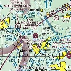
|
| Airport distance calculator |
|---|
|
|
| Sunrise and sunset |
|---|
|
Times for 04-Feb-2025
| | Local
(UTC-5) | | Zulu
(UTC) |
|---|
| Morning civil twilight | | 07:17 | | 12:17 |
| Sunrise | | 07:47 | | 12:47 |
| Sunset | | 17:51 | | 22:51 |
| Evening civil twilight | | 18:21 | | 23:21 |
|
| Current date and time |
|---|
| Zulu (UTC) | 04-Feb-2025 21:07:25 |
|---|
| Local (UTC-5) | 04-Feb-2025 16:07:25 |
|---|
|
| METAR |
|---|
KOZW
9nm W | 042055Z AUTO 33007KT 10SM BKN027 M05/M10 A3037 RMK AO2 T10501103
|
KPTK
17nm E | 042053Z 33008KT 10SM SCT030 OVC130 M05/M13 A3036 RMK AO2 SNE01 SLP294 P0000 60000 T10501128 51005 $
|
|
| TAF |
|---|
KPTK
17nm E | 041728Z 0418/0518 35011KT P6SM SCT025 BKN035 FM050100 01003KT P6SM SCT035 OVC080 FM051400 10007KT P6SM OVC100
|
|
| NOTAMs |
|---|
NOTAMs are issued by the DoD/FAA and will open in a separate window not controlled by AirNav.
|
|


