FAA INFORMATION EFFECTIVE 09 JULY 2026
Location
| FAA Identifier: | PTK |
| Lat/Long: | 42-39-56.2903N 083-25-13.8203W
42-39.938172N 083-25.230338W
42.6656362,-83.4205056
(estimated) |
| Elevation: | 980.6 ft. / 298.9 m (surveyed) |
| Variation: | 07W (2020) |
| From city: | 5 miles W of PONTIAC, MI |
| Time zone: | UTC -4 (UTC -5 during Standard Time) |
| Zip code: | 48327 |
Airport Operations
| Airport use: | Open to the public |
| Activation date: | 04/1940 |
| Control tower: | yes |
| ARTCC: | CLEVELAND CENTER |
| FSS: | LANSING FLIGHT SERVICE STATION |
| NOTAMs facility: | PTK (NOTAM-D service available) |
| Attendance: | CONTINUOUS |
| Wind indicator: | lighted |
| Segmented circle: | no |
| Lights: | WHEN ATCT CLSD ACTVT MALSR RWY 09R; REIL RWY 27L; PAPI RWY 09R & 27L; HIRL RWY 09R/27L - CTAF. |
| Beacon: | white-green (lighted land airport)
Operates sunset to sunrise. |
| Landing fee: | yes, LDG FEE FOR ACFT OVR 12500 LBS; AFT HRS/WKEND FEES APPLY TO ALL ACFT. |
| Fire and rescue: | ARFF index A |
| Airline operations: | CLSD TO SKEDD ACR OPS GTR THAN 9 PAX SEATS. 48 HR PPR FOR INDEX B SVC & UNSKED ACR OPS GTR THAN 30 PAX SEATS - CALL AMGR. |
| International operations: | CUST FEES APPLY TO ACFT OVR 10000 LBS; CTC US CUST
0700-2200 MON-FRI AT 248-666-7717; OTR TIMES MNM 3 HRS
PN AT 734-942-9000. |
Airport Communications
| CTAF: | 120.5 |
| UNICOM: | 122.95 |
| ATIS: | 125.025 |
| WX ASOS: | 125.025 (248-886-8551) |
| PONTIAC GROUND: | 121.9 121.65 [0600-0000] |
| PONTIAC TOWER: | 120.5 123.7 [0600-0000] |
| DETROIT APPROACH: | 132.35 |
| DETROIT DEPARTURE: | 132.35 |
| CLEARANCE DELIVERY: | 118.25 |
| FOREY STAR: | 134.3 |
| PETTE STAR: | 118.95 |
| WX AWOS-3P at VLL (13 nm SE): | 119.475 (248-288-4649) |
Nearby radio navigation aids
| VOR radial/distance | | VOR name | | Freq | | Var |
|---|
| SVMr029/17.2 | | SALEM VORTAC | | 114.30 | | 03W |
| FNTr148/23.1 | | FLINT VORTAC | | 116.90 | | 06W |
| DXOr001/27.3 | | DETROIT VOR/DME | | 113.40 | | 06W |
| CRLr006/37.1 | | CARLETON VOR/DME | | 115.70 | | 03W |
Airport Services
| Fuel available: | 100LL JET-A |
| Parking: | hangars and tiedowns |
| Airframe service: | MAJOR |
| Powerplant service: | MAJOR |
| Bottled oxygen: | NONE |
| Bulk oxygen: | HIGH |
Runway Information
Runway 9R/27L
| Dimensions: | 6521 x 150 ft. / 1988 x 46 m |
| Surface: | asphalt/grooved, in excellent condition |
| Weight bearing capacity: | | Single wheel: | 120.0 | | Double wheel: | 219.0 | | Double tandem: | 404.0 |
|
| Runway edge lights: | high intensity |
| RUNWAY 9R | | RUNWAY 27L |
| Latitude: | 42-39.876872N | | 42-39.920973N |
| Longitude: | 083-26.058877W | | 083-24.605528W |
| Elevation: | 980.4 ft. | | 971.5 ft. |
| Traffic pattern: | left | | left |
| Runway heading: | 095 magnetic, 088 true | | 275 magnetic, 268 true |
| Declared distances: | TORA:6520 TODA:6520 ASDA:6520 LDA:6520 | | TORA:6520 TODA:6520 ASDA:6520 LDA:6520 |
| Markings: | precision, in fair condition | | precision, in fair condition |
| Visual slope indicator: | 4-light PAPI on left (3.00 degrees glide path) | | 4-light PAPI on left (3.00 degrees glide path)
PAPI UNUSBL BYD 8 DEGS RIGHT OF CNTRLN. |
| RVR equipment: | touchdown | | rollout |
| Approach lights: | MALSR: 1,400 foot medium intensity approach lighting system with runway alignment indicator lights | | |
| Runway end identifier lights: | | | yes |
| Touchdown point: | yes, no lights | | yes, no lights |
| Instrument approach: | ILS | | |
Runway 9L/27R
| Dimensions: | 5676 x 100 ft. / 1730 x 30 m |
| Surface: | asphalt/porous friction courses, in fair condition |
| Weight bearing capacity: | | Single wheel: | 57.5 | | Double wheel: | 81.0 | | Double tandem: | 156.0 |
|
| Runway edge lights: | medium intensity |
| Operational restrictions: | RWY 09L/27R NOT AVBL FOR PART 121/PART 380 OPS WITH SKED PAX CARRYING OPS MORE THAN 9 PAX SEATS AND NON-SKED PAX CARRYING OPS MORE THAN 30 PAX SEATS. |
| RUNWAY 9L | | RUNWAY 27R |
| Latitude: | 42-39.967622N | | 42-40.005652N |
| Longitude: | 083-26.064050W | | 083-24.798923W |
| Elevation: | 973.8 ft. | | 972.6 ft. |
| Traffic pattern: | left | | left |
| Runway heading: | 095 magnetic, 088 true | | 275 magnetic, 268 true |
| Declared distances: | TORA:5675 TODA:5675 ASDA:5675 LDA:5675 | | TORA:5675 TODA:5675 ASDA:5675 LDA:5675 |
| Markings: | basic, in fair condition | | basic, in fair condition |
| Visual slope indicator: | 4-light PAPI on left (3.00 degrees glide path) | | 4-light PAPI on left (3.00 degrees glide path) |
| Runway end identifier lights: | yes | | yes |
| Touchdown point: | yes, no lights | | yes, no lights |
Runway 18/36
| Dimensions: | 2582 x 75 ft. / 787 x 23 m |
| Surface: | asphalt/porous friction courses, in fair condition |
| Weight bearing capacity: | |
| Operational restrictions: | RWY 18/36 NOT AVBL FOR PART 121/PART 380 OPS WITH SKED PAX CARRYING OPS MORE THAN 9 PAX SEATS AND NON-SKED PAX CARRYING OPS MORE THAN 30 PAX SEATS. DAY VFR USE AND CLSD TO ACFT OVR 12500 LBS. |
| RUNWAY 18 | | RUNWAY 36 |
| Latitude: | 42-40.141360N | | 42-39.720690N |
| Longitude: | 083-24.572827W | | 083-24.489800W |
| Elevation: | 973.4 ft. | | 969.4 ft. |
| Traffic pattern: | left | | left |
| Runway heading: | 179 magnetic, 172 true | | 359 magnetic, 352 true |
| Displaced threshold: | 650 ft. | | no |
| Visual slope indicator: | | | 2-light PAPI on left (3.00 degrees glide path) |
| Runway end identifier lights: | no | | no |
| Touchdown point: | yes, no lights | | yes, no lights |
Airport Ownership and Management from official FAA records
| Ownership: | Publicly-owned |
| Owner: | COUNTY OF OAKLAND
1200 N TELEGRAPH RD
PONTIAC, MI 48341
Phone 248-666-3900 |
| Manager: | CHERYL BUSH
6500 PATTERSON PKWY
WATERFORD, MI 48327-1683
Phone 248-666-3900 |
Additional Remarks
| A39-09R/27L | PCR VALUE: 400/F/A/X/T |
| A39-09L/27R | PCR VALUE: 400/F/A/X/T |
| - | ATCT UNA TO SEE MORE THAN 200 FT SOUTH OF RWY 36 THR AND TWY A2 BTN TWYS A & B. |
| - | 41D SPB LCTD 1.4 NM WEST. ACFT OPRG AT 41D WILL ANNC INTNS ON PTK CTAF. |
| - | ARFF PSNL MNT CTAF WHEN ATCT IS CLSD. |
| - | BIRDS & DEER ON & INVOF ARPT. |
| - | SEAPLANE TKOFS & LDGS PROHIBITED ON LAKE ANGELUS 4.5 NM ENE. |
| - | FOR CD WHEN ATCT IS CLSD CTC DETROIT APCH AT 734-955-1404. |
Instrument Procedures
NOTE: All procedures below are presented as PDF files. If you need a reader for these files, you should download the free Adobe Reader.NOT FOR NAVIGATION. Please procure official charts for flight.
FAA instrument procedures published for use from 09 July 2026 at 0901Z to 06 August 2026 at 0900Z.
STARs - Standard Terminal Arrivals |
|---|
| FOREY TWO (RNAV) **NEW** | |
download (159KB) |
| OKLND ONE (RNAV) **NEW** | |
download (144KB) |
| PETTE TWO (RNAV) **NEW** | |
download (209KB) |
| RRALF THREE (RNAV) **NEW** | |
download (161KB) |
IAPs - Instrument Approach Procedures |
|---|
| ILS OR LOC RWY 09R | |
download (262KB) |
| RNAV (GPS) RWY 09R **CHANGED** | |
download (231KB) |
| RNAV (GPS) RWY 27L | |
download (251KB) |
| LOC BC RWY 27L | |
download (215KB) |
| NOTE: Special Alternate Minimums apply | |
download (139KB) |
Departure Procedures |
|---|
| BARII THREE (RNAV) | |
download (156KB) |
| CCOBB THREE (RNAV) | |
download (193KB) |
| CLVIN THREE (RNAV) | |
download (177KB) |
| HHOWE FOUR (RNAV) | |
download (181KB) |
| KAYLN THREE (RNAV) | |
download (161KB) |
| KZLOV TWO (RNAV) | |
download (151KB) |
| LIDDS FOUR (RNAV) | |
download (180KB) |
| METRO FOUR | |
2 pages:
[1] [2] (363KB) |
| MIGGY THREE (RNAV) | |
download (194KB) |
| PAVYL THREE (RNAV) | |
download (170KB) |
| SNDRS THREE (RNAV) | |
download (209KB) |
| TRMML FOUR (RNAV) | |
download (162KB) |
| ZETTR FOUR (RNAV) | |
download (203KB) |
| NOTE: Special Take-Off Minimums/Departure Procedures apply | |
download (208KB) |
Other nearby airports with instrument procedures:
KVLL - Oakland/Troy Airport (13 nm SE)
Y47 - Oakland Southwest Airport (13 nm SW)
9G2 - Price's Airport (18 nm NW)
1D2 - Canton-Plymouth-Mettetal Airport (19 nm S)
D98 - Romeo State Airport (21 nm E)
|
|

Road maps at:
MapQuest
Bing
Google
| Aerial photo |
|---|
WARNING: Photo may not be current or correct
 Photo by Austen Mersereau
Photo taken 13-Oct-2020
looking southeast.
Photo by Austen Mersereau
Photo taken 13-Oct-2020
looking southeast.
Do you have a better or more recent aerial photo of Oakland County International Airport that you would like to share? If so, please send us your photo.
|
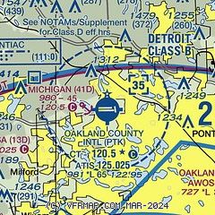
| Sectional chart |
|---|
|
CAUTION: Diagram may not be current
 Download PDF
of official airport diagram from the FAA
| Airport distance calculator |
|---|
|
|
| Sunrise and sunset |
|---|
|
Times for 16-Jul-2026
| | Local
(UTC-4) | | Zulu
(UTC) |
|---|
| Morning civil twilight | | 05:37 | | 09:37 |
| Sunrise | | 06:11 | | 10:11 |
| Sunset | | 21:08 | | 01:08 |
| Evening civil twilight | | 21:42 | | 01:42 |
|
| Current date and time |
|---|
| Zulu (UTC) | 16-Jul-2026 06:27:59 |
|---|
| Local (UTC-4) | 16-Jul-2026 02:27:59 |
|---|
|
| METAR |
|---|
| KPTK | 160553Z AUTO 00000KT 1 1/4SM HZ OVC022 22/19 A3005 RMK AO2 SLP168 60003 T02170189 10283 20217 51005 $
|
KVLL
13nm SE | 160615Z AUTO 36003KT 1 1/2SM HZ CLR 22/17 A3004 RMK AO2
|
|
| TAF |
|---|
| KPTK | 160520Z 1606/1706 36004KT 1 1/2SM FU SCT030 BKN150 FM161400 34007KT 3SM FU SCT035 BKN200 FM170100 11004KT 4SM FU BKN200
|
|
| NOTAMs |
|---|
NOTAMs are issued by the DoD/FAA and will open in a separate window not controlled by AirNav.
|
|
FBO, Fuel Providers, and Aircraft Ground Support |
|---|
| | 
Business Name | |
Contact | |
Services / Description | |
Fuel Prices | |
Comments | |
|---|
 |
|
ASRI 129.15
248-666-4300
[web site]
[email] |
|
PremierFBO PTK offers full-service private aviation support at Oakland County International Airport (PTK) near Detroit. We provide fueling, hangar space, deicing services, concierge services, crew amenities, and ground transportation to ensure a smooth and comfortable experience for pilots and passengers. Our modern facilities, professional team, and 24/7 service make every visit seamless--whether it's a quick turnaround or extended stay


|
|
 | | 100LL | Jet A | | FS | | $7.21 | | $5.71 | | Updated 15-Jul-2026 |
|
|

1 read write
|
|
 |
|
ASRI 131.325
248-666-3440
[web site]
[email]

|
|
Aviation fuel, Oxygen service, Aircraft parking (ramp or tiedown), Hangars, Passenger terminal and lounge, Aircraft maintenance, Avionics sales and service, ...


|
|
|
|
write
|
|
 |
|
ASRI 131.15
248-666-3630
toll-free 800-662-9612
[web site]
[email] |
|
Pentastar Aviation is one of the most awarded private aviation companies in the country. For over 50 years we have been operating 24 hours a day, 7 days a week to satisfy the needs of both individual and corporate air travelers. We offer accommodations that include luxurious pilot and passenger lounges, executive conference facilities, flight planning services, complimentary snacks, beverages, and Wi-Fi, heated hangars, secure ramp access, industry-leading Fivestar Gourmet catering, attentive concierge service, dedicated aircraft detail staff and services, and are a DCA Approved Gateway.


|
|
 | | 100LL | Jet A | | FS | | $7.30 | | $5.71 | | Updated 14-Jul-2026 |
|
|

3 read write
|
|


|
|
ASRI 131.525
248-666-0550
[web site]
[email] |
|
Maven, FBO of choice in Waterford, MI, is conveniently located midfield at the Oakland County Airport (KPTK) and boasts the most recently renovated FBO lobby, newest fuel trucks and ground support equipment, along with friendliest NATA Safety 1st Certified staff. Amenities include conference room, crew lounge, flight planning, crew cars, and complimentary snacks and beverages; even a slushy machine to quench your thirst. Maven Offers a full complement of FBO services, including Jet A and 100LL with volume discounts, deicing, lavatory service, and more happily arranged by Maven's expert staff.


|
|
|
|
write
|
|
 |
|
ASRI 131.225
248-666-2211
248-212-9425
[web site]
[email] |
|
THE BEST Executive Class "Full Service" Jet Fuel Price in America. Why are you paying so much for Jet fuel? No Better Service...No Better Price!
|
|
 | | 100LL | Jet A | | FS | | $6.95 | | $5.25 | | Updated 14-Jul-2026 |
|
|
write
|
|
| Royal Air |
|
248-666-6000
|
|
no information available
If you are affiliated with Royal Air and would like to show here your services, contact info, web link, logo, and more, click here
|
|
| 100LL | Jet A | | FS | | $6.20 | | $4.53 | | Updated 10-Jul-2026 |
|
|
write
|
|

|
| |
Aviation Businesses, Services, and Facilities |
|---|
| |
Business Name | |
Contact | |
Services / Description | |
Distance | |
Comments | |
|---|
| Michigan Helicopters |
|
248-236-5377
[web site]
[email] |
|
Pilot school (FAR Part 141), Flight training, Aircraft rental, Aerial tours / aerial sightseeing, Aircraft charters, Aerial photography, Aircraft parts, ...
|
|
on airport |
|
write
|
|
| |
Would you like to see your business listed on this page? |
|---|
| | If your business provides an interesting product or service to pilots, flight crews, aircraft, or users of the Oakland County International Airport, you should consider listing it here. To start the listing process, click on the button below

|


