FAA INFORMATION EFFECTIVE 11 JUNE 2026
Location
| FAA Identifier: | D98 |
| Lat/Long: | 42-47-46.7900N 082-58-27.2950W
42-47.779833N 082-58.454917W
42.7963306,-82.9742486
(estimated) |
| Elevation: | 738.2 ft. / 225.0 m (surveyed) |
| Variation: | 06W (1985) |
| From city: | 2 miles E of ROMEO, MI |
| Time zone: | UTC -4 (UTC -5 during Standard Time) |
| Zip code: | 48095 |
Airport Operations
| Airport use: | Open to the public |
| Activation date: | 02/1947 |
| Control tower: | no |
| ARTCC: | CLEVELAND CENTER |
| FSS: | LANSING FLIGHT SERVICE STATION |
| NOTAMs facility: | LAN (NOTAM-D service available) |
| Attendance: | MON-FRI 0800-1600 |
| Wind indicator: | lighted |
| Segmented circle: | no |
| Lights: | ACTVT REIL RWY 18 & 36; PAPI RWY 18 & 36; MIRL RWY 18/36 - CTAF. |
| Beacon: | white-green (lighted land airport)
Operates sunset to sunrise. |
Airport Communications
| CTAF/UNICOM: | 122.8 |
| SELFRIDGE APPROACH: | 119.6 |
| SELFRIDGE DEPARTURE: | 119.6 |
| WX AWOS-3P at VLL (18 nm SW): | 119.475 (248-288-4649) |
- APCH/DEP SVC PRVDD BY CLEVELAND ARTCC (ZOB) ON FREQS 126.525/285.525 (ALGONAC RCAG) WHEN SELFRIDGE APCH CTL CLSD.
Nearby radio navigation aids
| VOR radial/distance | | VOR name | | Freq | | Var |
|---|
| FNTr113/35.5 | | FLINT VORTAC | | 116.90 | | 06W |
| SVMr053/35.9 | | SALEM VORTAC | | 114.30 | | 03W |
| DXOr032/39.1 | | DETROIT VOR/DME | | 113.40 | | 06W |
Airport Services
| Fuel available: | 100LL JET-A |
| Parking: | hangars and tiedowns |
| Airframe service: | MAJOR |
| Powerplant service: | MAJOR |
| Bottled oxygen: | NONE |
| Bulk oxygen: | NONE |
Runway Information
Runway 18/36
| Dimensions: | 4003 x 75 ft. / 1220 x 23 m |
| Surface: | asphalt, in excellent condition |
| Runway edge lights: | medium intensity |
| RUNWAY 18 | | RUNWAY 36 |
| Latitude: | 42-48.109050N | | 42-47.450602N |
| Longitude: | 082-58.473637W | | 082-58.436192W |
| Elevation: | 737.9 ft. | | 728.3 ft. |
| Traffic pattern: | left | | left |
| Runway heading: | 184 magnetic, 178 true | | 004 magnetic, 358 true |
| Displaced threshold: | 469 ft. | | no |
| Markings: | nonprecision, in good condition | | nonprecision, in good condition |
| Visual slope indicator: | 4-light PAPI on left (3.00 degrees glide path) | | 4-light PAPI on left (3.00 degrees glide path) |
| Runway end identifier lights: | yes | | yes |
| Touchdown point: | yes, no lights | | yes, no lights |
| Obstructions: | 36 ft. tree, 536 ft. from runway, 223 ft. left of centerline, 9:1 slope to clear
APCH RATIO 20:1 TO DTHR. | | 27 ft. tree, 332 ft. from runway, 232 ft. right of centerline, 4:1 slope to clear |
Airport Ownership and Management from official FAA records
| Ownership: | Publicly-owned |
| Owner: | STATE OF MICHIGAN
2700 PORT LANSING RD
LANSING, MI 48906-2160
Phone 517-335-9841 |
| Manager: | DONALD SCHORSCH
15340 32 MILE RD
RAY, MI 48096-1017
Phone 586-336-9116
CELL 248-730-0561. |
Additional Remarks
| - | DEER & LRG BIRDS ON & INVOF ARPT. |
| - | FICONS UNMON DURG UNATNDD HRS EXC WINTER OPS. |
| - | FOR CD CTC SELFRIDGE APCH AT 586-239-5706, WHEN APCH CLSD CTC DETROIT APCH AT 734-955-1404. |
| - | RWY 18 +44 FT PLINE, 750-950 FT NORTH OF THR. |
Instrument Procedures
NOTE: All procedures below are presented as PDF files. If you need a reader for these files, you should download the free Adobe Reader.NOT FOR NAVIGATION. Please procure official charts for flight.
FAA instrument procedures published for use from 11 June 2026 at 0901Z to 09 July 2026 at 0900z.
IAPs - Instrument Approach Procedures |
|---|
| RNAV (GPS) RWY 18 | |
download (193KB) |
| RNAV (GPS) RWY 36 | |
download (199KB) |
| NOTE: Special Take-Off Minimums/Departure Procedures apply | |
download (122KB) |
Other nearby airports with instrument procedures:
57D - Ray Community Airport (5 nm SE)
KMTC - Selfridge Air National Guard Base (13 nm SE)
KVLL - Oakland/Troy Airport (18 nm SW)
KPHN - St Clair County International Airport (21 nm E)
D95 - Dupont/Lapeer Airport (21 nm NW)
|
|

Road maps at:
MapQuest
Bing
Google
| Aerial photo |
|---|
WARNING: Photo may not be current or correct

Do you have a better or more recent aerial photo of Romeo State Airport that you would like to share? If so, please send us your photo.
|
| Sectional chart |
|---|
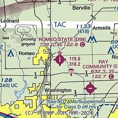
|
| Airport distance calculator |
|---|
|
|
| Sunrise and sunset |
|---|
|
Times for 16-Jun-2026
| | Local
(UTC-4) | | Zulu
(UTC) |
|---|
| Morning civil twilight | | 05:19 | | 09:19 |
| Sunrise | | 05:54 | | 09:54 |
| Sunset | | 21:11 | | 01:11 |
| Evening civil twilight | | 21:46 | | 01:46 |
|
| Current date and time |
|---|
| Zulu (UTC) | 16-Jun-2026 09:39:32 |
|---|
| Local (UTC-4) | 16-Jun-2026 05:39:32 |
|---|
|
| METAR |
|---|
KMTC
13nm SE | 160855Z AUTO 22008KT 10SM CLR 16/09 A2977 RMK AO2 SLP084 T01620087 57016 $
|
KVLL
18nm SW | 160915Z AUTO 23007KT 10SM CLR 14/09 A2980 RMK AO2
|
KD95
21nm NW | 151455Z AUTO 29006KT 10SM CLR 17/09 A2993 RMK AO2
|
KPTK
21nm W | 160853Z AUTO 22006KT FEW070 15/08 A2980 RMK AO2 SLP087 T01500078 56017 TSNO $
|
KPHN
21nm E | 160915Z AUTO 00000KT 10SM SCT080 BKN090 13/08 A2980 RMK AO2
|
KDET
24nm S | 160853Z 22009KT 10SM FEW080 16/08 A2981 RMK AO2 SLP091 T01610083 57015
|
|
| TAF |
|---|
KMTC
13nm SE | 151900Z 1519/1701 31009KT 9999 BKN065 QNH2977INS BECMG 1612/1613 25012G18KT 9999 SCT055 BKN070 QNH2964INS BECMG 1621/1622 26010G15KT 8000 -RA SCT050 BKN060 OVC080 QNH2964INS TX23/1618Z TN16/1610Z LAST NO AMDS AFT 1603 NEXT 1611
|
|
| NOTAMs |
|---|
NOTAMs are issued by the DoD/FAA and will open in a separate window not controlled by AirNav.
|
|

