FAA INFORMATION EFFECTIVE 14 MAY 2026
Location
| FAA Identifier: | 4B6 |
| Lat/Long: | 43-52-38.2000N 073-24-47.3000W
43-52.636667N 073-24.788333W
43.8772778,-73.4131389
(estimated) |
| Elevation: | 273.6 ft. / 83.4 m (surveyed) |
| Variation: | 15W (2000) |
| From city: | 2 miles NE of TICONDEROGA, NY |
| Time zone: | UTC -4 (UTC -5 during Standard Time) |
| Zip code: | 12883 |
Airport Operations
| Airport use: | Open to the public |
| Activation date: | 10/1978 |
| Control tower: | no |
| ARTCC: | BOSTON CENTER |
| FSS: | BURLINGTON FLIGHT SERVICE STATION |
| NOTAMs facility: | BTV (NOTAM-D service available) |
| Attendance: | UNATNDD |
| Wind indicator: | lighted |
| Segmented circle: | yes |
| Lights: | ACTVT REIL RWY 02 & 20; PAPI RWY 02 & 20; MIRL RWY 02/20 - CTAF. |
Airport Communications
| CTAF/UNICOM: | 122.8 |
| WX AWOS-3 at 6B0 (15 nm NE): | 118.575 (802-388-0255) |
- APCH/DEP SVC PRVDD BY BOSTON ARTCC (ZBW) ON FREQS 135.7/282.2 (MONTPELIER RCAG).
Nearby radio navigation aids
| VOR radial/distance | | VOR name | | Freq | | Var |
|---|
| BTVr213/32.7 | | BURLINGTON VOR/DME | | 117.50 | | 15W |
| NDB name | | Hdg/Dist | | Freq | | Var | | ID |
|---|
| SMUTO | | 312/22.3 | | 221 | | 15W | | DYO | -.. -.-- --- |
Airport Services
| Fuel available: | 100LL
100LL:100 LL SELF SVC CREDIT CARD. |
| Parking: | hangars and tiedowns |
Runway Information
Runway 2/20
| Dimensions: | 4041 x 60 ft. / 1232 x 18 m |
| Surface: | asphalt, in excellent condition |
| Runway edge lights: | medium intensity
RWY 02; 2 THR LGTS OTS INDEFLY. |
| RUNWAY 2 | | RUNWAY 20 |
| Latitude: | 43-52.303895N | | 43-52.968405N |
| Longitude: | 073-24.807803W | | 073-24.768483W |
| Elevation: | 273.6 ft. | | 264.9 ft. |
| Traffic pattern: | left | | right |
| Runway heading: | 017 magnetic, 002 true | | 197 magnetic, 182 true |
| Markings: | nonprecision, in good condition | | nonprecision, in good condition |
| Visual slope indicator: | 2-light PAPI on left (3.00 degrees glide path) | | 2-light PAPI on left (3.00 degrees glide path) |
| Runway end identifier lights: | yes | | yes |
| Touchdown point: | yes, no lights | | yes, no lights |
| Obstructions: | 10 ft. fence, 200 ft. from runway, 216 ft. left of centerline
10 FT FENCE 0-200 FT FM RWY 216 FT LEFT. | | 30 ft. trees, 200 ft. from runway, 116 ft. left of centerline
30 FT TREES, 0-200 FT FM RWY, 116 FT LEFT. |
Airport Ownership and Management from official FAA records
| Ownership: | Publicly-owned |
| Owner: | TOWN OF TICONDEROGA
132 MONTCALM ST
TICONDEROGA, NY 12883
Phone 518-585-6265 |
| Manager: | MARK A. WRIGHT
132 MONTCALM ST
TICONDEROGA, NY 12883
Phone 518-585-6265 |
Additional Remarks
| - | ARPT FEES - HNGR, TIE DOWN; LDG FOR PART 135, JET/TURBINE. |
| - | RWY 02; 50 FT TREES 1150 FT FM RWY END 50 FT LEFT. |
| - | WINTER OPS DECEMBER - MARCH CALL FOR RWY CONDITIONS. |
| - | WILDLIFE ON & INVOF ARPT. |
| - | FOR CD CTC BOSTON ARTCC AT 603-879-6859. |
Instrument Procedures
NOTE: All procedures below are presented as PDF files. If you need a reader for these files, you should download the free Adobe Reader.NOT FOR NAVIGATION. Please procure official charts for flight.
FAA instrument procedures published for use from 14 May 2026 at 0901Z to 11 June 2026 at 0900Z.
IAPs - Instrument Approach Procedures |
|---|
| RNAV (GPS) RWY 02 | |
download (317KB) |
| RNAV (GPS) RWY 20 | |
download (300KB) |
| NOTE: Special Take-Off Minimums/Departure Procedures apply | |
download (150KB) |
Other nearby airports with instrument procedures:
KRUT - Rutland/Southern Vermont Regional Airport (29 nm SE)
KLKP - Lake Placid Airport (33 nm NW)
KGFL - Floyd Bennett Memorial Airport (33 nm S)
KBTV - Patrick Leahy Burlington International Airport (37 nm N)
KMPV - Edward F Knapp State Airport (42 nm NE)
|
|

Road maps at:
MapQuest
Bing
Google
| Aerial photo |
|---|
WARNING: Photo may not be current or correct
 Photo by David Jablonski
Photo taken 09-Apr-2006
Photo by David Jablonski
Photo taken 09-Apr-2006
Do you have a better or more recent aerial photo of Ticonderoga Municipal Airport that you would like to share? If so, please send us your photo.
|
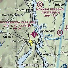
| Sectional chart |
|---|
|
| Airport distance calculator |
|---|
|
|
| Sunrise and sunset |
|---|
|
Times for 10-Jun-2026
| | Local
(UTC-4) | | Zulu
(UTC) |
|---|
| Morning civil twilight | | 04:36 | | 08:36 |
| Sunrise | | 05:12 | | 09:12 |
| Sunset | | 20:34 | | 00:34 |
| Evening civil twilight | | 21:10 | | 01:10 |
|
| Current date and time |
|---|
| Zulu (UTC) | 10-Jun-2026 21:14:33 |
|---|
| Local (UTC-4) | 10-Jun-2026 17:14:33 |
|---|
|
| METAR |
|---|
K6B0
15nm NE | 102055Z AUTO 20008KT 10SM SCT070 SCT080 28/18 A2975 RMK AO2 LTG DSNT SE AND NW T02770182
|
KRUT
30nm SE | 102056Z AUTO 00000KT 10SM OVC060 27/20 A2977 RMK AO2 LTG DSNT NE AND E SLP072 T02720200 56015
|
|
| TAF |
|---|
KRUT
30nm SE | 101736Z 1018/1118 VRB06KT P6SM SCT050 BKN060 PROB30 1019/1024 3SM -TSRA BR BKN050CB FM110000 00000KT 5SM -SHRA OVC030 FM111600 27006KT P6SM SCT030
|
KGFL
34nm S | 101738Z 1018/1118 19008KT P6SM SCT045 BKN170 PROB30 1021/1101 VRB10G18KT 4SM TSRA OVC025CB FM110100 20004KT P6SM SCT040 BKN200 PROB30 1101/1104 3SM -SHRA BKN020 FM110400 VRB03KT P6SM SCT015 BKN050 TEMPO 1105/1109 2SM BR SCT005 BKN015 FM111100 23005KT P6SM SCT035
|
|
| NOTAMs |
|---|
NOTAMs are issued by the DoD/FAA and will open in a separate window not controlled by AirNav.
|
|

