FAA INFORMATION EFFECTIVE 09 JULY 2026
Location
| FAA Identifier: | RUT |
| Lat/Long: | 43-31-47.0290N 072-56-58.6540W
43-31.783817N 072-56.977567W
43.5297303,-72.9496261
(estimated) |
| Elevation: | 787.3 ft. / 240.0 m (surveyed) |
| Variation: | 15W (1995) |
| From city: | 5 miles S of RUTLAND, VT |
| Time zone: | UTC -4 (UTC -5 during Standard Time) |
| Zip code: | 05759 |
Airport Operations
| Airport use: | Open to the public |
| Activation date: | 12/1942 |
| Control tower: | no |
| ARTCC: | BOSTON CENTER |
| FSS: | BURLINGTON FLIGHT SERVICE STATION |
| NOTAMs facility: | RUT (NOTAM-D service available) |
| Attendance: | 0700-1930
FOR AFT HRS SVC CALL 802-773-3348. |
| Wind indicator: | lighted |
| Segmented circle: | yes |
| Lights: | ACTVT MALSR RWY 19; REIL RWY 13; HIRL RWY 01/19; MIRL RWY 13/31 - CTAF. |
| Beacon: | white-green (lighted land airport)
Operates sunset to sunrise. |
| Landing fee: | yes, LDG FEES MAY APPLY FOR COML ACFT. |
| Fire and rescue: | ARFF index A |
| Airline operations: | ARFF SVC AVBL FOR NON-AIR CARRIER OPS, 48 HR PPR. CTC AMGR. |
Airport Communications
| CTAF/UNICOM: | 122.8 |
| WX AWOS-3PT: | 118.375 (802-747-3044) |
- APCH/DEP SVC PRVDD BY BOSTON ARTCC ON FREQS 135.7/282.2 (MONTPELIER RCAG).
Nearby radio navigation aids
| VOR radial/distance | | VOR name | | Freq | | Var |
|---|
| CAMr042/36.5 | | CAMBRIDGE VOR/DME | | 115.00 | | 14W |
| MPVr229/39.8 | | MONTPELIER VOR/DME | | 116.90 | | 16W |
| NDB name | | Hdg/Dist | | Freq | | Var | | ID |
|---|
| SMUTO | | 193/10.6 | | 221 | | 15W | | DYO | -.. -.-- --- |
| CLAREMONT | | 307/27.0 | | 233 | | 16W | | CNH | -.-. -. .... |
| HANOVER | | 268/35.1 | | 276 | | 15W | | LAH | .-.. .- .... |
Airport Services
| Fuel available: | 100LL JET-A |
| Parking: | hangars and tiedowns |
| Airframe service: | MAJOR |
| Powerplant service: | MAJOR |
| Bottled oxygen: | NONE |
| Bulk oxygen: | NONE |
Runway Information
Runway 1/19
| Dimensions: | 5304 x 100 ft. / 1617 x 30 m |
| Surface: | asphalt/grooved, in good condition |
| Weight bearing capacity: | | Single wheel: | 40.0 | | Double wheel: | 68.0 |
|
| Runway edge lights: | high intensity |
| Operational restrictions: | RWY 01/19 NOT AVBL FOR PART 121/PART 380 OPS WITH SKED PAX CARRYING OPS MORE THAN 9 PAX SEATS AND NON-SKED PAX CARRYING OPS MORE THAN 30 PAX SEATS. 90 DAY PPR FOR UNSKED ACR OPS GTR THAN 30 PAX SEATS - CALL AMGR. |
| RUNWAY 1 | | RUNWAY 19 |
| Latitude: | 43-31.444112N | | 43-32.316848N |
| Longitude: | 072-56.968490W | | 072-56.999257W |
| Elevation: | 781.3 ft. | | 774.0 ft. |
| Traffic pattern: | left | | right |
| Runway heading: | 014 magnetic, 359 true | | 194 magnetic, 179 true |
| Displaced threshold: | 300 ft. | | no |
| Declared distances: | TORA:5304 TODA:5304 ASDA:5304 LDA:5004 | | TORA:5004 TODA:5004 ASDA:5004 LDA:5004 |
| Markings: | nonprecision, in good condition | | precision, in good condition |
| Visual slope indicator: | pulsating/steady burning VASI on right (3.50 degrees glide path)
OTS UFN. | | 4-light PAPI on left (3.20 degrees glide path) |
| Approach lights: | | | MALSR: 1,400 foot medium intensity approach lighting system with runway alignment indicator lights |
| Runway end identifier lights: | | | no |
| Touchdown point: | yes, no lights | | yes, no lights |
| Instrument approach: | | | ILS/DME |
| Obstructions: | 135 ft. hill, 4800 ft. from runway, 34:1 slope to clear | | none |
Runway 13/31
| Dimensions: | 3169 x 75 ft. / 966 x 23 m |
| Surface: | asphalt, in good condition |
| Weight bearing capacity: | |
| Runway edge lights: | medium intensity |
| Operational restrictions: | RWY 13/31 NOT AVBL FOR PART 121/PART 380 OPS WITH SKED PAX CARRYING OPS MORE THAN 9 PAX SEATS AND NON-SKED PAX CARRYING OPS MORE THAN 30 PAX SEATS. 90 DAY PPR FOR UNSKED ACR OPS GTR THAN 30 PAX SEATS - CALL AMGR. |
| RUNWAY 13 | | RUNWAY 31 |
| Latitude: | 43-31.747078N | | 43-31.497000N |
| Longitude: | 072-57.281632W | | 072-56.652407W |
| Elevation: | 782.3 ft. | | 782.2 ft. |
| Traffic pattern: | left | | left |
| Runway heading: | 134 magnetic, 119 true | | 314 magnetic, 299 true |
| Markings: | basic, in good condition | | basic, in good condition |
| Runway end identifier lights: | yes | | |
| Touchdown point: | yes, no lights | | yes, no lights |
| Obstructions: | 16 ft. road, 325 ft. from runway, 7:1 slope to clear | | 20 ft. trees, 600 ft. from runway, 100 ft. right of centerline, 20:1 slope to clear |
Airport Ownership and Management from official FAA records
| Ownership: | Publicly-owned |
| Owner: | STATE OF VERMONT
219 N MAIN ST
BARRE, VT 05641
Phone 802-272-7725 |
| Manager: | CHRISTOPHER BEITZEL
219 N MAIN ST
BARRE, VT 05641
Phone 802-272-7725 |
Additional Remarks
| A39-13/31 | PCR VALUE: 172/F/D/X/T |
| A39-01/19 | PCR VALUE: 271/F/D/X/T |
| - | ACFT WITH WING SPANS EXCEEDING 79 FT AUZD TO USE TWY H & TWY B EAST OF RWY 1/19 & RWY 13/31 FOR TAX & RWYS 01 & 19 FOR TKOF & LDG. NOISE SENSITIVE AREA SE OF ARPT CTC AMGR. |
| - | FOR CD CTC BOSTON ARTCC AT 603-879-6859. |
| - | RWY CONDS MAY NOT BE MNT OR RPRTD WHEN ARPT IS UNATNDD. |
| - | TYPE I & TYPE IV DEICING AVBL. |
| - | BIRDS ON & INVOF ARPT. |
| - | COLD TEMPERATURE AIRPORT. ALTITUDE CORRECTION REQUIRED AT OR BELOW -7C. |
| - | USE TWY A TO TAX TO OR FM AER 01 OR 19. |
| - | TWY C CNCTS MAIN APRON WITH TWY A. |
Instrument Procedures
NOTE: All procedures below are presented as PDF files. If you need a reader for these files, you should download the free Adobe Reader.NOT FOR NAVIGATION. Please procure official charts for flight.
FAA instrument procedures published for use from 09 July 2026 at 0901Z to 06 August 2026 at 0900Z.
IAPs - Instrument Approach Procedures |
|---|
| ILS Y OR LOC Y RWY 19 | |
download (279KB) |
| ILS Z OR LOC Z RWY 19 | |
download (291KB) |
| RNAV (GPS) RWY 01 | |
download (253KB) |
| RNAV (GPS) Y RWY 19 | |
download (279KB) |
| RNAV (GPS) Z RWY 19 | |
download (320KB) |
| NOTE: Special Alternate Minimums apply | |
download (152KB) |
| NOTE: Special Take-Off Minimums/Departure Procedures apply | |
download (514KB) |
Other nearby airports with instrument procedures:
KVSF - Hartness State Airport (Springfield) (22 nm SE)
KCNH - Claremont Municipal Airport (27 nm E)
KLEB - Lebanon Municipal Airport (29 nm E)
4B6 - Ticonderoga Municipal Airport (29 nm NW)
KGFL - Floyd Bennett Memorial Airport (31 nm W)
|
|

Road maps at:
MapQuest
Bing
Google
| Aerial photo |
|---|
WARNING: Photo may not be current or correct
 Photo taken 11-Jul-2011
looking northeast.
Photo taken 11-Jul-2011
looking northeast.
Do you have a better or more recent aerial photo of Rutland/Southern Vermont Regional Airport that you would like to share? If so, please send us your photo.
|
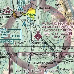
| Sectional chart |
|---|
|
| Airport distance calculator |
|---|
|
|
| Sunrise and sunset |
|---|
|
Times for 25-Jul-2026
| | Local
(UTC-4) | | Zulu
(UTC) |
|---|
| Morning civil twilight | | 05:01 | | 09:01 |
| Sunrise | | 05:35 | | 09:35 |
| Sunset | | 20:22 | | 00:22 |
| Evening civil twilight | | 20:55 | | 00:55 |
|
| Current date and time |
|---|
| Zulu (UTC) | 25-Jul-2026 22:51:44 |
|---|
| Local (UTC-4) | 25-Jul-2026 18:51:44 |
|---|
|
| METAR |
|---|
| KRUT | 252156Z AUTO 14006KT 10SM BKN070 26/13 A3002 RMK AO2 SLP157 T02610128
|
|
| TAF |
|---|
| KRUT | 251720Z 2518/2618 VRB03KT P6SM FEW200 FM260300 13008KT P6SM SCT200 FM261300 VRB03KT P6SM SCT250
|
|
| NOTAMs |
|---|
NOTAMs are issued by the DoD/FAA and will open in a separate window not controlled by AirNav.
|
|


