FAA INFORMATION EFFECTIVE 09 JULY 2026
Location
| FAA Identifier: | CNH |
| Lat/Long: | 43-22-13.8160N 072-22-05.5450W
43-22.230267N 072-22.092417W
43.3705044,-72.3682069
(estimated) |
| Elevation: | 543.3 ft. / 165.6 m (surveyed) |
| Variation: | 16W (1995) |
| From city: | 1 mile W of CLAREMONT, NH |
| Time zone: | UTC -4 (UTC -5 during Standard Time) |
| Zip code: | 03743 |
Airport Operations
| Airport use: | Open to the public |
| Control tower: | no |
| ARTCC: | BOSTON CENTER |
| FSS: | BANGOR FLIGHT SERVICE STATION |
| NOTAMs facility: | BGR (NOTAM-D service available) |
| Attendance: | MON-FRI 1000-1600
FOR ARPT SVCS, CALL 603-542-2282. |
| Wind indicator: | lighted |
| Segmented circle: | yes |
| Lights: | ACTVT REIL RWY 29; MIRL RWY 11/29 - CTAF. |
| Beacon: | white-green (lighted land airport)
ROTG BCN DFCLT TO SEE FM THE N WHEN FOLIAGE IS ON THE TREES. Operates sunset to sunrise. |
Airport Communications
| CTAF/UNICOM: | 122.7 |
| WX ASOS at VSF (7 nm W): | 121.425 (802-886-6006) |
| WX ASOS at LEB (16 nm N): | 118.65 (603-298-8780) |
- APCH/DEP SVC PRVDD BY BOSTON ARTCC ON FREQS 134.7/269.475 (LEBANON RCAG).
Nearby radio navigation aids
| VOR radial/distance | | VOR name | | Freq | | Var |
|---|
| CONr300/35.8 | | CONCORD VOR/DME | | 112.90 | | 15W |
| NDB name | | Hdg/Dist | | Freq | | Var | | ID |
|---|
| CLAREMONT | | at field | | 233 | | 16W | | CNH | -.-. -. .... |
| HANOVER | | 218/21.6 | | 276 | | 15W | | LAH | .-.. .- .... |
| SMUTO | | 143/32.6 | | 221 | | 15W | | DYO | -.. -.-- --- |
Airport Services
| Fuel available: | 100LL
100LL:FUEL SELF SVC 24 HRS BY CREDIT CARD. |
| Parking: | tiedowns |
| Airframe service: | MINOR |
| Powerplant service: | MINOR |
| Bottled oxygen: | NONE |
| Bulk oxygen: | NONE |
Runway Information
Runway 11/29
| Dimensions: | 3098 x 75 ft. / 944 x 23 m |
| Surface: | asphalt, in excellent condition |
| Weight bearing capacity: | |
| Runway edge lights: | medium intensity |
| RUNWAY 11 | | RUNWAY 29 |
| Latitude: | 43-22.244355N | | 43-22.216160N |
| Longitude: | 072-22.441442W | | 072-21.743402W |
| Elevation: | 532.8 ft. | | 541.9 ft. |
| Traffic pattern: | left | | left |
| Runway heading: | 109 magnetic, 093 true | | 289 magnetic, 273 true |
| Markings: | basic, in good condition | | nonprecision, in good condition |
| Visual slope indicator: | | | 2-light PAPI on left (4.00 degrees glide path) |
| Runway end identifier lights: | no | | yes |
| Touchdown point: | yes, no lights | | yes, no lights |
| Obstructions: | 226 ft. tree, 2917 ft. from runway, 255 ft. left of centerline, 12:1 slope to clear | | 32 ft. tree, 731 ft. from runway, 295 ft. left of centerline, 16:1 slope to clear
5 FT BRUSH 88 FT R OF CNTRLN. |
Airport Ownership and Management from official FAA records
| Ownership: | Publicly-owned |
| Owner: | CITY OF CLAREMONT
CITY HALL
CLAREMONT, NH 03743
Phone 603-542-7002 |
| Manager: | JAMES CHAMBERLAIN
100 BROAD ST
CLAREMONT, NH 03743
Phone (603) 542-5156 |
Additional Remarks
| A39-11/29 | PCR VALUE: 383/F/A/X/T |
| - | HAZ BCNS ON SRNDG HILLS. |
| - | EXPC DOWNDRAFT ON APCH TO RWY 29. |
| - | TKOF, LNDG & TAX ON UNPAVED AREAS PROHIBITED. |
| - | WILDLIFE ON & INVOF ARPT. |
| - | COLD TEMPERATURE AIRPORT. ALTITUDE CORRECTION REQUIRED AT OR BELOW -24C. |
| - | FOR CD CTC BOSTON ARTCC AT 603-879-6859. |
Instrument Procedures
NOTE: All procedures below are presented as PDF files. If you need a reader for these files, you should download the free Adobe Reader.NOT FOR NAVIGATION. Please procure official charts for flight.
FAA instrument procedures published for use from 09 July 2026 at 0901Z to 06 August 2026 at 0900Z.
IAPs - Instrument Approach Procedures |
|---|
| RNAV (GPS) RWY 29 | |
download (236KB) |
| NOTE: Special Take-Off Minimums/Departure Procedures apply | |
download (553KB) |
Other nearby airports with instrument procedures:
KVSF - Hartness State Airport (Springfield) (7 nm W)
2B3 - Parlin Field Airport (8 nm E)
KLEB - Lebanon Municipal Airport (16 nm N)
KRUT - Rutland/Southern Vermont Regional Airport (27 nm W)
KEEN - Dillant/Hopkins Airport (29 nm S)
|
|

Road maps at:
MapQuest
Bing
Google
| Aerial photo |
|---|
WARNING: Photo may not be current or correct
 Photo by Dick Bicknell
Taken in August 2009
Photo by Dick Bicknell
Taken in August 2009
Do you have a better or more recent aerial photo of Claremont Municipal Airport that you would like to share? If so, please send us your photo.
|
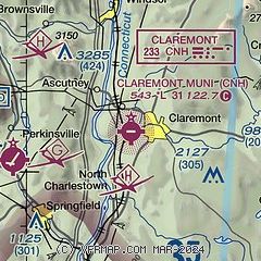
| Sectional chart |
|---|
|
| Airport distance calculator |
|---|
|
|
| Sunrise and sunset |
|---|
|
Times for 30-Jul-2026
| | Local
(UTC-4) | | Zulu
(UTC) |
|---|
| Morning civil twilight | | 05:05 | | 09:05 |
| Sunrise | | 05:38 | | 09:38 |
| Sunset | | 20:14 | | 00:14 |
| Evening civil twilight | | 20:46 | | 00:46 |
|
| Current date and time |
|---|
| Zulu (UTC) | 30-Jul-2026 07:33:17 |
|---|
| Local (UTC-4) | 30-Jul-2026 03:33:17 |
|---|
|
| METAR |
|---|
KVSF
7nm W | 300654Z AUTO 00000KT 4SM -RA BR OVC017 18/17 A2976 RMK AO2 RAB38 SLP077 P0001 T01830167 $
|
KLEB
16nm N | 300705Z AUTO 35004KT 1 1/2SM +RA BR FEW015 BKN024 OVC034 17/17 A2977 RMK AO2 P0009 T01670167
|
|
| TAF |
|---|
KLEB
16nm N | 300523Z 3006/3106 00000KT P6SM SCT020 BKN029 OVC050 FM300800 01002KT 4SM BR OVC007 FM301500 35005KT 5SM -SHRA BR BKN025 OVC050 FM302000 VRB04KT P6SM BKN050
|
|
| NOTAMs |
|---|
NOTAMs are issued by the DoD/FAA and will open in a separate window not controlled by AirNav.
|
|

