FAA INFORMATION EFFECTIVE 09 JULY 2026
Location
| FAA Identifier: | 51D |
| Lat/Long: | 46-20-58.9000N 098-44-06.0000W
46-20.981667N 098-44.100000W
46.3496944,-98.7350000
(estimated) |
| Elevation: | 1603.5 ft. / 488.7 m (surveyed) |
| Variation: | 05E (2015) |
| From city: | 1 mile WSW of EDGELEY, ND |
| Time zone: | UTC -5 (UTC -6 during Standard Time) |
| Zip code: | 58433 |
Airport Operations
| Airport use: | Open to the public |
| Activation date: | 01/1961 |
| Control tower: | no |
| ARTCC: | MINNEAPOLIS CENTER |
| FSS: | GRAND FORKS FLIGHT SERVICE STATION |
| NOTAMs facility: | GFK (NOTAM-D service available) |
| Attendance: | UNATNDD |
| Wind indicator: | lighted |
| Segmented circle: | yes |
| Lights: | ACTVT PAPI RWY 14 & 32; MIRL RWY 14/32 - CTAF. |
| Beacon: | white-green (lighted land airport)
Operates sunset to sunrise. |
Airport Communications
- APCH/DEP SVC PRVDD BY MINNEAPOLIS ARTCC ON FREQS 124.2/270.3 (WOODWORTH RCAG).
Nearby radio navigation aids
| VOR radial/distance | | VOR name | | Freq | | Var |
|---|
| JMSr180/35.1 | | JAMESTOWN VOR/DME | | 114.50 | | 04E |
Airport Services
| Fuel available: | 100LL JET-A
100LL:100LL AND JET A FUEL AVBL SELF SVC WITH CREDIT CARD. |
| Parking: | hangars and tiedowns |
| Airframe service: | NONE |
| Powerplant service: | NONE |
| Bottled oxygen: | NONE |
| Bulk oxygen: | NONE |
Runway Information
Runway 14/32
| Dimensions: | 3600 x 60 ft. / 1097 x 18 m |
| Surface: | asphalt, in good condition |
| Weight bearing capacity: | |
| Runway edge lights: | medium intensity |
| RUNWAY 14 | | RUNWAY 32 |
| Latitude: | 46-21.166178N | | 46-20.658027N |
| Longitude: | 098-44.308180W | | 098-43.868885W |
| Elevation: | 1600.8 ft. | | 1591.8 ft. |
| Traffic pattern: | left | | left |
| Runway heading: | 144 magnetic, 149 true | | 324 magnetic, 329 true |
| Markings: | nonprecision, in good condition | | nonprecision, in good condition |
| Visual slope indicator: | 2-light PAPI on left (3.00 degrees glide path) | | 2-light PAPI on left (3.00 degrees glide path) |
| Touchdown point: | yes, no lights | | yes, no lights |
Runway 9/27
| Dimensions: | 2800 x 116 ft. / 853 x 35 m |
| Surface: | turf, in good condition |
| RUNWAY 9 | | RUNWAY 27 |
| Latitude: | 46-21.077000N | | 46-21.066550N |
| Longitude: | 098-44.448500W | | 098-43.783333W |
| Elevation: | 1603.5 ft. | | 1588.0 ft. |
| Traffic pattern: | left | | left |
| Runway heading: | 086 magnetic, 091 true | | 266 magnetic, 271 true |
| Markings: | none | | none |
| Touchdown point: | yes, no lights | | yes, no lights |
Airport Ownership and Management from official FAA records
| Ownership: | Publicly-owned |
| Owner: | EDGELEY MUNI ARPT AUTH
PO BOX 293
EDGELEY, ND 58433
Phone (701) 320-8740 |
| Manager: | DAVE LUX
PO BOX 334, BOX 345
EDGELEY, ND 58433
Phone (701) 320-8740
ADDNL CONTACT CHAIRMAN JUSTIN FREDENBURG 701-709-0114. |
Additional Remarks
| A52-09 | RWY 27 55 FT PLINE LCTD 1205 FT FM THLD 21:1 CLNC SLOPE. |
| - | SNOW REMOVAL IREG; CONFIRM WINTER CONDITIONS BEFORE USE. CALL 701-709-0114/701-320-8740 FOR UPDATES. |
| - | DEER AND BIRDS ON & INV OF ARPT. |
| - | FOR CD CTC MINNEAPOLIS ARTCC AT 651-463-5588. |
Instrument Procedures
NOTE: All procedures below are presented as PDF files. If you need a reader for these files, you should download the free Adobe Reader.NOT FOR NAVIGATION. Please procure official charts for flight.
FAA instrument procedures published for use from 09 July 2026 at 0901Z to 06 August 2026 at 0900Z.
IAPs - Instrument Approach Procedures |
|---|
| RNAV (GPS) RWY 14 **CHANGED** | |
download (196KB) |
| RNAV (GPS) RWY 32 **CHANGED** | |
download (209KB) |
| NOTE: Special Take-Off Minimums/Departure Procedures apply | |
download (238KB) |
Other nearby airports with instrument procedures:
4E7 - Ellendale Municipal Airport (22 nm SE)
2D5 - Oakes Municipal Airport (29 nm E)
KASY - Ashley Municipal Airport (32 nm SW)
KJMS - Jamestown Regional Airport (35 nm N)
6L3 - Lisbon Municipal Airport (42 nm E)
|
|

Road maps at:
MapQuest
Bing
Google
| Aerial photo |
|---|
WARNING: Photo may not be current or correct

Do you have a better or more recent aerial photo of Edgeley Municipal Airport that you would like to share? If so, please send us your photo.
|
| Sectional chart |
|---|
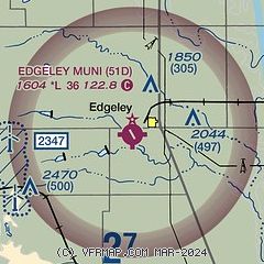
|
| Airport distance calculator |
|---|
|
|
| Sunrise and sunset |
|---|
|
Times for 02-Aug-2026
| | Local
(UTC-5) | | Zulu
(UTC) |
|---|
| Morning civil twilight | | 05:44 | | 10:44 |
| Sunrise | | 06:19 | | 11:19 |
| Sunset | | 21:04 | | 02:04 |
| Evening civil twilight | | 21:38 | | 02:38 |
|
| Current date and time |
|---|
| Zulu (UTC) | 02-Aug-2026 12:32:33 |
|---|
| Local (UTC-5) | 02-Aug-2026 07:32:33 |
|---|
|
| METAR |
|---|
K2D5
29nm E | 021215Z AUTO 17013KT 18/18 A2991 RMK AO2
|
KJMS
35nm N | 021156Z AUTO 17015G21KT 10SM CLR 18/16 A2984 RMK AO2 SLP097 T01830161 10194 20183 58017
|
KGWR
46nm E | 021215Z AUTO 18006KT 9SM CLR 18/18 A2991 RMK A01
|
KBAC
46nm NE | 021215Z AUTO 18011KT 9SM CLR 19/19 A2988 RMK AO2
|
|
| TAF |
|---|
KJMS
35nm N | 021146Z 0212/0312 17010KT P6SM FEW110 SCT250 FM021400 17015G25KT P6SM FEW110 SCT250 FM021600 17020G30KT P6SM FEW250 FM030300 16015G25KT P6SM FEW120 SCT250 FM030600 16010KT P6SM FEW110 SCT250
|
|
| NOTAMs |
|---|
NOTAMs are issued by the DoD/FAA and will open in a separate window not controlled by AirNav.
|
|

