FAA INFORMATION EFFECTIVE 19 FEBRUARY 2026
Location
| FAA Identifier: | 6L3 |
| Lat/Long: | 46-26-49.1040N 097-43-41.5760W
46-26.818400N 097-43.692933W
46.4469733,-97.7282156
(estimated) |
| Elevation: | 1240.3 ft. / 378.0 m (surveyed) |
| Variation: | 04E (2010) |
| From city: | 2 miles W of LISBON, ND |
| Time zone: | UTC -6 (UTC -5 during Daylight Saving Time) |
| Zip code: | 58054 |
Airport Operations
| Airport use: | Open to the public |
| Activation date: | 11/1987 |
| Control tower: | no |
| ARTCC: | MINNEAPOLIS CENTER |
| FSS: | GRAND FORKS FLIGHT SERVICE STATION |
| NOTAMs facility: | GFK (NOTAM-D service available) |
| Attendance: | ON CALL
FOR ARPT SVCS OCT-APR CALL 701-683-5501. |
| Wind indicator: | lighted |
| Segmented circle: | yes |
| Lights: | ACTVT PAPI RWY 14 & 32; MIRL RWY 14/32 - CTAF. |
| Beacon: | white-green (lighted land airport)
Operates sunset to sunrise. |
Airport Communications
| CTAF: | 122.9 |
| WX AWOS-3 at GWR (14 nm S): | 118.325 (701-678-6801) |
- APCH/DEP SVC PRVDD BY MINNEAOPLIS ARTCC ON 127.35/278.3 (FARGO RCAG).
Airport Services
| Fuel available: | 100LL
100LL:SELF SVC FUEL AVBL H24 VIA CREDIT CARD. |
| Parking: | hangars and tiedowns |
Runway Information
Runway 14/32
| Dimensions: | 3397 x 60 ft. / 1035 x 18 m |
| Surface: | asphalt, in good condition |
| Weight bearing capacity: | |
| Runway edge lights: | medium intensity |
| RUNWAY 14 | | RUNWAY 32 |
| Latitude: | 46-27.115117N | | 46-26.630980N |
| Longitude: | 097-43.880853W | | 097-43.476905W |
| Elevation: | 1231.8 ft. | | 1225.4 ft. |
| Traffic pattern: | left | | left |
| Runway heading: | 146 magnetic, 150 true | | 326 magnetic, 330 true |
| Markings: | nonprecision, in good condition | | nonprecision, in good condition |
| Visual slope indicator: | 2-light PAPI on left (3.00 degrees glide path) | | 2-light PAPI on left (3.00 degrees glide path) |
| Runway end identifier lights: | | | no |
| Touchdown point: | yes, no lights | | yes, no lights |
| Obstructions: | 6 ft. fence, 275 ft. from runway, 260 ft. left of centerline, 12:1 slope to clear | | 20 ft. road, 590 ft. from runway, 310 ft. left of centerline, 19:1 slope to clear |
Runway 3/21
| Dimensions: | 1320 x 100 ft. / 402 x 30 m |
| Surface: | turf, in good condition |
| RUNWAY 3 | | RUNWAY 21 |
| Latitude: | 46-26.587830N | | 46-26.767667N |
| Longitude: | 097-43.817167W | | 097-43.641180W |
| Elevation: | 1240.3 ft. | | 1228.4 ft. |
| Traffic pattern: | left | | left |
| Runway heading: | 030 magnetic, 034 true | | 210 magnetic, 214 true |
| Markings: | none | | none |
| Runway end identifier lights: | no | | no |
| Touchdown point: | yes, no lights | | yes, no lights |
Airport Ownership and Management from official FAA records
| Ownership: | Publicly-owned |
| Owner: | LISBON AIRPORT AUTHORITY
PO BOX 1079
LISBON, ND 58054
Phone 701-683-4140
CITY HALL OF LISBON. |
| Manager: | BEN HALSTENSON
6683 129TH AVE SE, 423 MAIN STREET
LISBON, ND 58054
Phone 701-739-5463 |
Additional Remarks
| - | CTC AMGR BFR USE AFT WINTER STORM DUE TO IREG SN REMOVAL; CALL 701-739-5463. |
| - | ULTRALIGHT ACTIVITY ON OR NEAR VICINITY OF AIRPORT. |
| - | RY 03/21 CLSD WINTER MONTHS DUE TO LACK OF SNOW REMOVAL. |
| - | BIRDS & DEER INVOF AIRPORT. |
| - | FOR CD CTC MINNEAPOLIS ARTCC AT 651-463-5588. |
Instrument Procedures
NOTE: All procedures below are presented as PDF files. If you need a reader for these files, you should download the free Adobe Reader.NOT FOR NAVIGATION. Please procure official charts for flight.
FAA instrument procedures published for use from 19 February 2026 at 0901Z to 19 March 2026 at 0900Z.
IAPs - Instrument Approach Procedures |
|---|
| RNAV (GPS) RWY 14 **CHANGED** | |
download (192KB) |
| RNAV (GPS) RWY 32 **CHANGED** | |
download (216KB) |
| NOTE: Special Take-Off Minimums/Departure Procedures apply | |
download (240KB) |
Other nearby airports with instrument procedures:
KGWR - Gwinner Airport/Roger Melroe Field (14 nm S)
2D5 - Oakes Municipal Airport (22 nm SW)
KBAC - Barnes County Municipal Airport (32 nm N)
K74 - Robert Odegaard Field Airport (32 nm E)
5N8 - Casselton Robert Miller Regional Airport (32 nm NE)
|
|

Road maps at:
MapQuest
Bing
Google
| Aerial photo |
|---|
WARNING: Photo may not be current or correct

Do you have a better or more recent aerial photo of Lisbon Municipal Airport that you would like to share? If so, please send us your photo.
|
| Sectional chart |
|---|
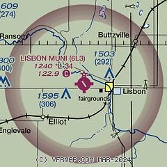
|
| Airport distance calculator |
|---|
|
|
| Sunrise and sunset |
|---|
|
Times for 16-Mar-2026
| | Local
(UTC-5) | | Zulu
(UTC) |
|---|
| Morning civil twilight | | 07:13 | | 12:13 |
| Sunrise | | 07:43 | | 12:43 |
| Sunset | | 19:37 | | 00:37 |
| Evening civil twilight | | 20:07 | | 01:07 |
|
| Current date and time |
|---|
| Zulu (UTC) | 16-Mar-2026 13:53:36 |
|---|
| Local (UTC-5) | 16-Mar-2026 08:53:36 |
|---|
|
| METAR |
|---|
KGWR
14nm S | 161335Z AUTO 32011KT 10SM CLR M17/M17 A3026 RMK A01
|
K2D5
22nm SW | 161335Z AUTO 32009KT M18/ A3027 RMK AO2
|
|
| TAF |
|---|
KFAR
48nm NE | 161120Z 1612/1712 34012G18KT P6SM SKC FM161700 35016G24KT P6SM SCT035 FM162300 34014KT P6SM SKC FM170200 35009KT P6SM SKC FM170900 16005KT P6SM SCT200
|
KJMS
48nm NW | 161141Z 1612/1712 31009KT P6SM FEW040 FEW300 FM161700 34011KT P6SM FEW250 FM162300 36008KT P6SM SCT220 FM170300 08005KT P6SM BKN180 FM170600 15007KT P6SM SCT120 BKN150 FM171000 16011KT P6SM BKN090 OVC120
|
|
| NOTAMs |
|---|
NOTAMs are issued by the DoD/FAA and will open in a separate window not controlled by AirNav.
|
|

