FAA INFORMATION EFFECTIVE 19 FEBRUARY 2026
Location
| FAA Identifier: | 5B5 |
| Lat/Long: | 46-29-39.3385N 099-45-31.3627W
46-29.655642N 099-45.522712W
46.4942607,-99.7587119
(estimated) |
| Elevation: | 1985 ft. / 605 m (estimated) |
| Variation: | 09E (1985) |
| From city: | 1 mile SE of NAPOLEON, ND |
| Time zone: | UTC -6 (UTC -5 during Daylight Saving Time) |
| Zip code: | 58561 |
Airport Operations
| Airport use: | Open to the public |
| Activation date: | 07/1970 |
| Control tower: | no |
| ARTCC: | MINNEAPOLIS CENTER |
| FSS: | GRAND FORKS FLIGHT SERVICE STATION |
| NOTAMs facility: | GFK (NOTAM-D service available) |
| Attendance: | UNATNDD |
| Wind indicator: | lighted |
| Segmented circle: | no |
| Lights: | DUSK-0600. |
Airport Communications
Airport Services
Runway Information
Runway 12/30
| Dimensions: | 3220 x 50 ft. / 981 x 15 m |
| Surface: | asphalt, in good condition |
| Weight bearing capacity: | |
| Runway edge lights: | low intensity |
| RUNWAY 12 | | RUNWAY 30 |
| Latitude: | 46-29.831400N | | 46-29.499783N |
| Longitude: | 099-45.757500W | | 099-45.158717W |
| Elevation: | 1960.0 ft. | | 1985.0 ft. |
| Traffic pattern: | left | | left |
| Runway heading: | 119 magnetic, 128 true | | 299 magnetic, 308 true |
| Markings: | basic, in fair condition | | basic, in fair condition |
| Runway end identifier lights: | no | | no |
| Obstructions: | 164 ft. bldg, 3160 ft. from runway, 410 ft. left of centerline, 18:1 slope to clear | | none |
Runway 8/26
| Dimensions: | 1600 x 80 ft. / 488 x 24 m |
| Surface: | turf, in good condition |
| RUNWAY 8 | | RUNWAY 26 |
| Latitude: | 46-29.636650N | | 46-29.634583N |
| Longitude: | 099-45.843300W | | 099-45.462150W |
| Elevation: | 1961.0 ft. | | 1965.0 ft. |
| Traffic pattern: | left | | left |
| Runway end identifier lights: | no | | no |
| Touchdown point: | yes, no lights | | yes, no lights |
Airport Ownership and Management from official FAA records
| Ownership: | Publicly-owned |
| Owner: | NAPOLEON ARPT AUTH
PO BOX 165
NAPOLEON, ND 58561
Phone 701-426-4537 |
| Manager: | SHANE WEIGEL
PO BOX 165
NAPOLEON, ND 58561
Phone 701-426-4537 |
Additional Remarks
| A52-08 | 28 FT BLDG 1100 FT DIST, 100 FT L; 45 FT TREES 1000 DIST, 100 FT R. |
| A52-26 | 25 FT RAILROAD 500 FT DIST, 200 FT R. |
| - | REG SNOW REMOVAL. CFM WINTER COND WITH AMGR DURG DAY ON 701-321-0767 OR 701-426-4537. |
| - | RWY 08/26 CLSD OCT-APR DUE TO LACK OF SNOW REMOVAL. |
| - | RWY 08 HAS 3 FT DITCH 250 FT FROM THR OUTBOUND. |
| - | DEER & BIRDS ON & INVOF ARPT. |
| - | FOR CD CTC MINNEAPOLIS ARTCC AT 651-463-5588. |
Instrument Procedures
There are no published instrument procedures at 5B5.
Some nearby airports with instrument procedures:
7L2 - Linton Municipal Airport (26 nm SW)
KASY - Ashley Municipal Airport (33 nm SE)
51D - Edgeley Municipal Airport (43 nm E)
KBIS - Bismarck Municipal Airport (44 nm NW)
Y19 - Mandan Regional Airport/Lawler Field (50 nm W)
|
|

Road maps at:
MapQuest
Bing
Google
| Aerial photo |
|---|
WARNING: Photo may not be current or correct

Do you have a better or more recent aerial photo of Napoleon Municipal Airport that you would like to share? If so, please send us your photo.
|
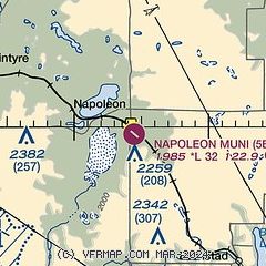
| Sectional chart |
|---|
|
| Airport distance calculator |
|---|
|
|
| Sunrise and sunset |
|---|
|
Times for 02-Mar-2026
| | Local
(UTC-6) | | Zulu
(UTC) |
|---|
| Morning civil twilight | | 06:47 | | 12:47 |
| Sunrise | | 07:18 | | 13:18 |
| Sunset | | 18:25 | | 00:25 |
| Evening civil twilight | | 18:55 | | 00:55 |
|
| Current date and time |
|---|
| Zulu (UTC) | 02-Mar-2026 16:54:34 |
|---|
| Local (UTC-6) | 02-Mar-2026 10:54:34 |
|---|
|
| METAR |
|---|
K7L2
26nm SW | 021635Z AUTO 13006KT 10SM CLR M05/M06 A3004 RMK AO2
|
KBIS
44nm W | 021552Z 05003KT 10SM CLR M09/M12 A3003 RMK AO2 SLP203 T10941122
|
KY19
50nm W | 021615Z AUTO 00000KT 10SM M08/M09 A3001 RMK AO2
|
|
| TAF |
|---|
KBIS
44nm W | 021136Z 0212/0312 15005KT P6SM FEW250
|
|
| NOTAMs |
|---|
NOTAMs are issued by the DoD/FAA and will open in a separate window not controlled by AirNav.
|
|

