FAA INFORMATION EFFECTIVE 11 JUNE 2026
Location
| FAA Identifier: | 5J9 |
| Lat/Long: | 34-05-18.3000N 078-51-53.7000W
34-05.305000N 078-51.895000W
34.0884167,-78.8649167
(estimated) |
| Elevation: | 99.3 ft. / 30.3 m (surveyed) |
| Variation: | 08W (2000) |
| From city: | 3 miles NE of LORIS, SC |
| Time zone: | UTC -4 (UTC -5 during Standard Time) |
| Zip code: | 29569 |
Airport Operations
| Airport use: | Open to the public |
| Activation date: | 07/1961 |
| Control tower: | no |
| ARTCC: | JACKSONVILLE CENTER |
| FSS: | ANDERSON FLIGHT SERVICE STATION |
| NOTAMs facility: | AND (NOTAM-D service available) |
| Attendance: | UNATNDD |
| Wind indicator: | lighted |
| Segmented circle: | yes |
| Beacon: | white-green (lighted land airport)
Operates sunset to sunrise. |
Airport Communications
| CTAF: | 122.9 |
| MYRTLE BEACH APPROACH: | 119.2 |
| MYRTLE BEACH DEPARTURE: | 119.2 |
| WX AWOS-3 at CPC (13 nm NE): | 118.375 (910-642-7508) |
| WX ASOS at CRE (18 nm SE): | 119.625 (843-361-2802) |
- APCH/DEP SVC PRVDD BY JACKSONVILLE ARTCC ON FREQ 134.375/317.550 (MYRTLE BEACH RCAG) WHEN MYRTLE BEACH APCH CTL CLSD.
Nearby radio navigation aids
| VOR radial/distance | | VOR name | | Freq | | Var |
|---|
| CREr340/17.9 | | GRAND STRAND VORTAC | | 114.40 | | 03W |
Airport Services
| Parking: | tiedowns |
| Airframe service: | NONE |
| Powerplant service: | NONE |
| Bottled oxygen: | NONE |
| Bulk oxygen: | NONE |
Runway Information
Runway 8/26
| Dimensions: | 3694 x 60 ft. / 1126 x 18 m |
| Surface: | asphalt, in good condition |
| Weight bearing capacity: | |
| Runway edge lights: | low intensity |
| RUNWAY 8 | | RUNWAY 26 |
| Latitude: | 34-05.218735N | | 34-05.390357N |
| Longitude: | 078-52.246725W | | 078-51.544410W |
| Elevation: | 99.2 ft. | | 99.3 ft. |
| Traffic pattern: | left | | left |
| Runway heading: | 082 magnetic, 074 true | | 262 magnetic, 254 true |
| Displaced threshold: | 200 ft. | | no |
| Markings: | basic, in good condition | | basic, in good condition |
| Visual slope indicator: | | | 2-box SAVASI on left (3.50 degrees glide path) |
| Touchdown point: | yes, no lights | | yes, no lights |
| Obstructions: | 17 ft. road, 200 ft. from runway, 1:1 slope to clear
RWY 08 ROADWAY AND 50FT TREES 150' TO 175' R;DIST 0 TO 200 FT FROM RWY. AIRCRAFT ACTIVITY APRON 150FT R, DIST 0 TO 125' FROM RWY. | | 86 ft. trees, 1759 ft. from runway, 10 ft. right of centerline, 18:1 slope to clear |
Airport Ownership and Management from official FAA records
| Ownership: | Publicly-owned |
| Owner: | HORRY COUNTY
PO BOX 1236
CONWAY, SC 29526
Phone 843-448-1580 |
| Manager: | JUDI OLMSTEAD
1100 JETPORT RD
MYRTLE BEACH, SC 29577
Phone 843-448-1580 |
Additional Remarks
| - | 30 FT POWER LINE 180 FT SOUTH OF RWY 8-26. |
| - | BIRDS ON AND INVOF ARPT. |
| - | FOR CD CTC MYRTLE BEACH APCH AT 843-477-2727 OR 843-477-2704, WHEN APCH CLSD CTC JACKSONVILLE ARTCC AT 904-845-1592. |
Instrument Procedures
NOTE: All procedures below are presented as PDF files. If you need a reader for these files, you should download the free Adobe Reader.NOT FOR NAVIGATION. Please procure official charts for flight.
FAA instrument procedures published for use from 11 June 2026 at 0901Z to 09 July 2026 at 0900z.
IAPs - Instrument Approach Procedures |
|---|
| GPS RWY 26 | |
download (148KB) |
| NOTE: Special Take-Off Minimums/Departure Procedures apply | |
download (141KB) |
Other nearby airports with instrument procedures:
KCPC - Columbus County Regional Airport (13 nm NE)
KCRE - Grand Strand Airport (18 nm SE)
KHYW - Conway-Horry County Airport (20 nm SW)
KMAO - Marion County Airport (24 nm W)
KMYR - Myrtle Beach International Airport (25 nm S)
|
|

Road maps at:
MapQuest
Bing
Google
| Aerial photo |
|---|
WARNING: Photo may not be current or correct

Do you have a better or more recent aerial photo of Twin City Airport that you would like to share? If so, please send us your photo.
|
| Sectional chart |
|---|
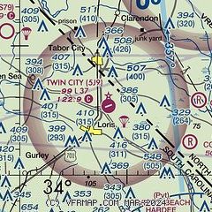
|
| Airport distance calculator |
|---|
|
|
| Sunrise and sunset |
|---|
|
Times for 14-Jun-2026
| | Local
(UTC-4) | | Zulu
(UTC) |
|---|
| Morning civil twilight | | 05:35 | | 09:35 |
| Sunrise | | 06:04 | | 10:04 |
| Sunset | | 20:27 | | 00:27 |
| Evening civil twilight | | 20:56 | | 00:56 |
|
| Current date and time |
|---|
| Zulu (UTC) | 14-Jun-2026 12:01:40 |
|---|
| Local (UTC-4) | 14-Jun-2026 08:01:40 |
|---|
|
| METAR |
|---|
KCPC
13nm NE | 141155Z AUTO 00000KT 1/4SM FG OVC003 25/24 A2994 RMK AO2 P0002 60003 70016 T02450238 10245 20222
|
KCRE
18nm SE | 141153Z 21007KT 10SM CLR 27/23 A2993 RMK AO1 SLP134 70021 T02720233 10272 20250 52017
|
KHYW
20nm SW | 141155Z AUTO 20003KT 10SM CLR 25/24 A2993 RMK AO2
|
KMAO
24nm W | 141155Z AUTO 18005KT 10SM CLR 24/24 A2992 RMK AO2
|
KMYR
25nm S | 141153Z 23005KT 10SM CLR 27/24 A2995 RMK AO2 SLP140 7//// T02670239 10272 20256 51018 $
|
|
| TAF |
|---|
KCRE
18nm SE | 141120Z 1412/1512 21005KT P6SM SCT035 BKN250 FM141500 19010KT P6SM BKN200 FM141900 20014G22KT P6SM BKN200 PROB30 1419/1501 4SM -TSRA OVC025CB FM150100 22013KT P6SM BKN150 FM151000 25008KT P6SM SCT150
|
|
| NOTAMs |
|---|
NOTAMs are issued by the DoD/FAA and will open in a separate window not controlled by AirNav.
|
|

