FAA INFORMATION EFFECTIVE 03 SEPTEMBER 2026
Location
| FAA Identifier: | 5Y2 |
| Lat/Long: | 44-19-52.4500N 084-47-27.5500W
44-19.874167N 084-47.459167W
44.3312361,-84.7909861
(estimated) |
| Elevation: | 1165 ft. / 355.1 m (surveyed) |
| Variation: | 05W (1985) |
| From city: | 1 mile W of HOUGHTON LAKE HEIGHTS, MI |
| Time zone: | UTC -4 (UTC -5 during Standard Time) |
| Zip code: | 48629 |
Airport Operations
| Airport use: | Open to the public |
| Activation date: | 04/1940 |
| Control tower: | no |
| ARTCC: | MINNEAPOLIS CENTER |
| FSS: | LANSING FLIGHT SERVICE STATION |
| NOTAMs facility: | LAN (NOTAM-D service available) |
| Attendance: | UNATNDD |
| Wind indicator: | yes |
| Segmented circle: | yes |
Airport Communications
| CTAF: | 122.9 |
| WX ASOS at HTL (5 nm E): | 118.05 (989-200-3352) |
Nearby radio navigation aids
| VOR radial/distance | | VOR name | | Freq | | Var |
|---|
| CGGr193/(21.2) | | GRAYLING VOR | | 109.80 | | 06W |
| TVCr124/38.3 | | TRAVERSE CITY VOR/DME | | 114.60 | | 02W |
| NDB name | | Hdg/Dist | | Freq | | Var | | ID |
|---|
| GRAYLING | | 182/25.2 | | 359 | | 06W | | GYG | --. -.-- --. |
Airport Services
| Parking: | tiedowns |
| Airframe service: | NONE |
| Powerplant service: | NONE |
| Bottled oxygen: | NONE |
| Bulk oxygen: | NONE |
Runway Information
Runway 16/34
| Dimensions: | 2750 x 104 ft. / 838 x 32 m |
| Surface: | turf, in good condition |
| Runway edge markings: | RWY & DTHR MKD WITH 3 FT YELLOW CONES. |
| RUNWAY 16 | | RUNWAY 34 |
| Latitude: | 44-20.086667N | | 44-19.661667N |
| Longitude: | 084-47.568333W | | 084-47.350000W |
| Elevation: | 1165.0 ft. | | 1165.0 ft. |
| Traffic pattern: | left | | left |
| Runway heading: | 165 magnetic, 160 true | | 345 magnetic, 340 true |
| Displaced threshold: | 550 ft. | | 900 ft. |
| Obstructions: | 53 ft. trees, 80 ft. left of centerline
CTLG OBSTN EXCEEDS A 45 DEG SLP. RWY 16 +50FT TREES, DIST 200FT, 137FT L, APCH SLOPE 4:1 DSPLCD THLD. | | 26 ft. trees, 40 ft. from runway, 70 ft. left of centerline, 1:1 slope to clear
RWY 34 +50FT TREE, DIST 0FT, 123FT L, APCH SLOPE 0:1 DSPLCD THLD. |
Airport Ownership and Management from official FAA records
| Ownership: | Publicly-owned |
| Owner: | STATE OF MICHIGAN
2700 PORT LANSING RD
LANSING, MI 48906-2172
Phone 517-335-9681 |
| Manager: | CHRIS AMBROSE
125 CRISTI LN
HOUGHTON LAKE, MI 48629-9683
Phone 616-540-1324 |
Additional Remarks
| - | SNOW REMOVAL IREG - CTC AMGR AT 616-540-1324 TO VFY CONDS. |
| - | DEER, BIRDS & WILDLIFE ON & INVOF ARPT. |
| - | FOR CD CTC MINNEAPOLIS ARTCC AT 651-463-5588. |
Instrument Procedures
There are no published instrument procedures at 5Y2.
Some nearby airports with instrument procedures:
KHTL - Roscommon County/Blodgett Memorial Airport (5 nm E)
KGOV - Grayling Army Airfield (21 nm N)
KGDW - Gladwin Zettel Memorial Airport (26 nm SE)
Y31 - West Branch Community Airport (27 nm E)
KCAD - Wexford County Airport (27 nm W)
|
|

Road maps at:
MapQuest
Bing
Google
| Aerial photo |
|---|
WARNING: Photo may not be current or correct
 Photo courtesy of Bev Smith, photographer, & Brad Smith, pilot.
Photo taken 18-Apr-2009
from 1000 ft. AGL.
Photo courtesy of Bev Smith, photographer, & Brad Smith, pilot.
Photo taken 18-Apr-2009
from 1000 ft. AGL.
Do you have a better or more recent aerial photo of Houghton Lake State Airport that you would like to share? If so, please send us your photo.
|
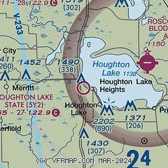
| Sectional chart |
|---|
|
| Airport distance calculator |
|---|
|
|
| Sunrise and sunset |
|---|
|
Times for 27-Sep-2026
| | Local
(UTC-4) | | Zulu
(UTC) |
|---|
| Morning civil twilight | | 07:04 | | 11:04 |
| Sunrise | | 07:33 | | 11:33 |
| Sunset | | 19:27 | | 23:27 |
| Evening civil twilight | | 19:56 | | 23:56 |
|
| Current date and time |
|---|
| Zulu (UTC) | 27-Sep-2026 09:25:26 |
|---|
| Local (UTC-4) | 27-Sep-2026 05:25:26 |
|---|
|
| METAR |
|---|
KHTL
5nm E | 270853Z AUTO 00000KT 10SM CLR 03/03 A3016 RMK AO2 SLP216 T00330033 58007 $
|
|
| NOTAMs |
|---|
NOTAMs are issued by the DoD/FAA and will open in a separate window not controlled by AirNav.
|
|


