FAA INFORMATION EFFECTIVE 15 MAY 2025
Location
| FAA Identifier: | 5G0 |
| Lat/Long: | 42-58-52.6130N 077-56-06.8930W
42-58.876883N 077-56.114883W
42.9812814,-77.9352481
(estimated) |
| Elevation: | 780.3 ft. / 237.8 m (surveyed) |
| Variation: | 11W (1985) |
| From city: | 2 miles E of LE ROY, NY |
| Time zone: | UTC -4 (UTC -5 during Standard Time) |
| Zip code: | 14482 |
Airport Operations
| Airport use: | Open to the public |
| Activation date: | 01/1964 |
| Control tower: | no |
| ARTCC: | CLEVELAND CENTER |
| FSS: | BUFFALO FLIGHT SERVICE STATION |
| NOTAMs facility: | BUF (NOTAM-D service available) |
| Attendance: | MON-FRI 1000-1600
EXCP MAJOR HOL. |
| Wind indicator: | lighted |
| Segmented circle: | no |
| Lights: | SS-SR, ACTVT REIL RWY 10 & 28; PAPI RWY 10 & 28; MIRL RWY 10/28 - CTAF. |
| Beacon: | white-green (lighted land airport)
Operates sunset to sunrise. |
Airport Communications
| CTAF/UNICOM: | 122.8 |
| ROCHESTER APPROACH: | 123.7 |
| ROCHESTER DEPARTURE: | 123.7 |
| WX AWOS-3PT at GVQ (11 nm W): | 127.525 (585-343-6369) |
| WX ASOS at ROC (14 nm NE): | 124.825 (585-205-7835) |
| WX AWOS-2 at 01G (15 nm S): | 118.525 (585-237-0235) |
Nearby radio navigation aids
| VOR radial/distance | | VOR name | | Freq | | Var |
|---|
| GEEr324/12.5 | | GENESEO VOR/DME | | 108.20 | | 09W |
| ROCr247/14.1 | | ROCHESTER VOR/DME | | 110.00 | | 12W |
Airport Services
| Fuel available: | 100LL |
| Parking: | hangars and tiedowns |
| Airframe service: | MINOR |
| Powerplant service: | MINOR |
| Bottled oxygen: | NONE |
| Bulk oxygen: | NONE |
Runway Information
Runway 10/28
| Dimensions: | 3854 x 60 ft. / 1175 x 18 m |
| Surface: | asphalt, in good condition |
| Weight bearing capacity: | |
| Runway edge lights: | medium intensity |
| RUNWAY 10 | | RUNWAY 28 |
| Latitude: | 42-58.892695N | | 42-58.861055N |
| Longitude: | 077-56.546403W | | 077-55.683355W |
| Elevation: | 780.0 ft. | | 778.3 ft. |
| Traffic pattern: | left | | left |
| Runway heading: | 104 magnetic, 093 true | | 284 magnetic, 273 true |
| Markings: | nonprecision, in fair condition | | nonprecision, in fair condition |
| Visual slope indicator: | 2-light PAPI on left (3.00 degrees glide path) | | 2-light PAPI on left (3.50 degrees glide path) |
| Runway end identifier lights: | yes | | yes |
| Touchdown point: | yes, no lights | | yes, no lights |
| Obstructions: | 40 ft. tree, 214 ft. from runway, 220 ft. left of centerline
8 FT FENCE; 0-199 FT DSTC, 94 FT LEFT. | | 8 ft. fence, 201 ft. from runway, 100 ft. right of centerline
8 FT FENCE; 0-199 FT DSTC, 100 FT RIGHT. |
Airport Ownership and Management from official FAA records
| Ownership: | Privately-owned |
| Owner: | LEROY AVIATION SERVICES INC
8267 EAST MAIN ROAD
LE ROY, NY 14482
Phone 585-768-4560 |
| Manager: | RAY DETOR
283 WESTMINSTER ROAD
ROCHESTER, NY 14607-3229
Phone 585-259-9308 |
Additional Remarks
| - | DEER ON AND INVOF ARPT. |
| - | FOR CD CTC CLEVELAND ARTCC AT 440-774-0490. |
Instrument Procedures
NOTE: All procedures below are presented as PDF files. If you need a reader for these files, you should download the free Adobe Reader.NOT FOR NAVIGATION. Please procure official charts for flight.
FAA instrument procedures published for use from 15 May 2025 at 0901Z to 13 June 2025 at 0900z.
IAPs - Instrument Approach Procedures |
|---|
| RNAV (GPS) RWY 10 | |
download (178KB) |
| RNAV (GPS) RWY 28 | |
download (174KB) |
| VOR-A | |
download (182KB) |
| NOTE: Special Take-Off Minimums/Departure Procedures apply | |
download (150KB) |
Other nearby airports with instrument procedures:
KGVQ - Genesee County Airport (11 nm W)
7G0 - Ledgedale Airpark (12 nm N)
KROC - Frederick Douglass/Greater Rochester International Airport (14 nm NE)
9G6 - Pine Hill Airport (19 nm NW)
9G3 - Akron Airport/Jesson Field (24 nm W)
|
|

Road maps at:
MapQuest
Bing
Google
| Aerial photo |
|---|
WARNING: Photo may not be current or correct

Do you have a better or more recent aerial photo of Le Roy Airport that you would like to share? If so, please send us your photo.
|
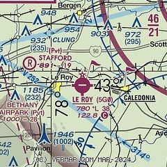
| Sectional chart |
|---|
|
| Airport distance calculator |
|---|
|
|
| Sunrise and sunset |
|---|
|
Times for 19-May-2025
| | Local
(UTC-4) | | Zulu
(UTC) |
|---|
| Morning civil twilight | | 05:13 | | 09:13 |
| Sunrise | | 05:46 | | 09:46 |
| Sunset | | 20:31 | | 00:31 |
| Evening civil twilight | | 21:04 | | 01:04 |
|
| Current date and time |
|---|
| Zulu (UTC) | 20-May-2025 02:27:45 |
|---|
| Local (UTC-4) | 19-May-2025 22:27:45 |
|---|
|
| METAR |
|---|
KGVQ
11nm W | 200156Z AUTO 28006KT 10SM OVC002 09/02 A3003 RMK AO2 SLP173 T00890017 PNO $
|
KROC
14nm NE | 200154Z 30004KT 10SM CLR 09/02 A3002 RMK AO2 SLP171 T00940022
|
|
| TAF |
|---|
KROC
14nm NE | 191728Z 1918/2018 32012KT P6SM SCT025 FM200200 32003KT P6SM FEW250 FM201600 36007KT P6SM FEW250
|
|
| NOTAMs |
|---|
NOTAMs are issued by the DoD/FAA and will open in a separate window not controlled by AirNav.
|
|


