FAA INFORMATION EFFECTIVE 19 MARCH 2026
Location
| FAA Identifier: | 6S2 |
| Lat/Long: | 43-58-58.1460N 124-06-40.9220W
43-58.969100N 124-06.682033W
43.9828183,-124.1113672
(estimated) |
| Elevation: | 50.8 ft. / 15.5 m (surveyed) |
| Variation: | 15E (2025) |
| From city: | 1 mile N of FLORENCE, OR |
| Time zone: | UTC -7 (UTC -8 during Standard Time) |
| Zip code: | 97439 |
Airport Operations
| Airport use: | Open to the public |
| Activation date: | 04/1947 |
| Control tower: | no |
| ARTCC: | SEATTLE CENTER |
| FSS: | MC MINNVILLE FLIGHT SERVICE STATION |
| NOTAMs facility: | MMV (NOTAM-D service available) |
| Attendance: | 0830-1630 |
| Wind indicator: | yes |
| Segmented circle: | yes |
| Lights: | ACTVT REIL 15 & 33; PAPI 15 & 33; MIRL RWY 15/33 - CTAF. |
| Beacon: | white-green (lighted land airport)
Operates sunset to sunrise. |
Airport Communications
| CTAF/UNICOM: | 122.8 |
| WX AWOS-3PT: | 118.225 (541-997-8664) |
Nearby radio navigation aids
| VOR radial/distance | | VOR name | | Freq | | Var |
|---|
| OTHr349/34.1 | | NORTH BEND VOR/DME | | 113.85 | | 15E |
| ONPr169/35.6 | | NEWPORT VORTAC | | 117.10 | | 15E |
| EUGr243/39.2 | | EUGENE VORTAC | | 112.90 | | 15E |
Airport Services
| Fuel available: | 100LL JET-A |
| Parking: | tiedowns |
| Bottled oxygen: | NONE |
| Bulk oxygen: | NONE |
Runway Information
Runway 15/33
| Dimensions: | 3000 x 60 ft. / 914 x 18 m |
| Surface: | asphalt, in good condition |
| Weight bearing capacity: | |
| Runway edge lights: | medium intensity |
| RUNWAY 15 | | RUNWAY 33 |
| Latitude: | 43-59.210102N | | 43-58.728095N |
| Longitude: | 124-06.756008W | | 124-06.608082W |
| Elevation: | 50.8 ft. | | 40.1 ft. |
| Traffic pattern: | right | | left |
| Runway heading: | 152 magnetic, 167 true | | 332 magnetic, 347 true |
| Markings: | basic, in good condition | | basic, in good condition |
| Visual slope indicator: | 2-light PAPI on left (4.00 degrees glide path) | | 2-light PAPI on left (4.00 degrees glide path)
UNUSBLE BYD 5 DEGS LEFT OF CNTRLN. |
| Runway end identifier lights: | yes | | yes |
| Touchdown point: | yes, no lights | | yes, no lights |
| Obstructions: | 75 ft. hill, 1517 ft. from runway, 125 ft. left of centerline, 17:1 slope to clear
RW 33 HAS 15' FENCE CROSSING APPROACH AT 518'. | | 63 ft. trees, 695 ft. from runway, 140 ft. both sides of centerline, 7:1 slope to clear |
Airport Ownership and Management from official FAA records
| Ownership: | Publicly-owned |
| Owner: | CITY OF FLORENCE
250 HIGHWAY 101
FLORENCE, OR 97439
Phone 541-997-3437 |
| Manager: | MIKE MILLER
2001 AIRPORT WAY
FLORENCE, OR 97439
Phone 541-997-4016
APMGR CELL 541 991 2410 |
Additional Remarks
| - | BIRDS, DEER & WILDLIFE ON & INVOF ARPT. |
| - | FOR CD CTC SEATTLE ARTCC AT 253-351-3694. |
Instrument Procedures
There are no published instrument procedures at 6S2.
Some nearby airports with instrument procedures:
KOTH - Southwest Oregon Regional Airport (34 nm S)
KONP - Newport Municipal Airport (36 nm N)
KEUG - Mahlon Sweet Field Airport (40 nm E)
KCVO - Corvallis Municipal Airport (47 nm NE)
77S - Hobby Field Airport (48 nm E)
|
|

Road maps at:
MapQuest
Bing
Google
| Aerial photo |
|---|
WARNING: Photo may not be current or correct
 Photo by Debbie Golob of Florence, OR
Photo taken 16-Jan-2014
looking northwest.
Photo by Debbie Golob of Florence, OR
Photo taken 16-Jan-2014
looking northwest.
Do you have a better or more recent aerial photo of Florence Municipal Airport that you would like to share? If so, please send us your photo.
|
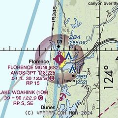
| Sectional chart |
|---|
|
| Airport distance calculator |
|---|
|
|
| Sunrise and sunset |
|---|
|
Times for 12-Apr-2026
| | Local
(UTC-7) | | Zulu
(UTC) |
|---|
| Morning civil twilight | | 06:09 | | 13:09 |
| Sunrise | | 06:39 | | 13:39 |
| Sunset | | 19:55 | | 02:55 |
| Evening civil twilight | | 20:25 | | 03:25 |
|
| Current date and time |
|---|
| Zulu (UTC) | 13-Apr-2026 04:39:17 |
|---|
| Local (UTC-7) | 12-Apr-2026 21:39:17 |
|---|
|
| METAR |
|---|
| K6S2 | 130415Z AUTO 00000KT 10SM SCT030 BKN050 OVC060 10/10 A2996 RMK AO2
|
|
| TAF |
|---|
KOTH
34nm S | 121729Z 1218/1318 VRB03KT P6SM BKN008 OVC110 FM130200 33004KT 6SM -SHRA BR OVC015 FM131000 32005KT 6SM BR OVC015
|
KONP
35nm N | 121903Z 1219/1318 30007KT 1 1/2SM -SHRA BKN003 OVC011 FM130100 31007KT 4SM -SHRA BR BKN005 OVC011 FM130600 27005KT 6SM BR VCSH FEW007 OVC015
|
KEUG
40nm E | 121731Z 1218/1318 21007KT P6SM -SHRA SCT015 OVC035 FM122200 27008KT P6SM -SHRA FEW020 OVC045 FM130500 24007KT P6SM -SHRA SCT015 OVC025 FM131000 21006KT P6SM SCT015 OVC025
|
|
| NOTAMs |
|---|
NOTAMs are issued by the DoD/FAA and will open in a separate window not controlled by AirNav.
|
|

