FAA INFORMATION EFFECTIVE 07 AUGUST 2025
Location
| FAA Identifier: | 6Y8 |
| Lat/Long: | 45-43-16.6534N 085-31-11.0144W
45-43.277557N 085-31.183573W
45.7212926,-85.5197262
(estimated) |
| Elevation: | 664 ft. / 202.4 m (surveyed) |
| Variation: | 05W (1985) |
| From city: | 2 miles S of BEAVER ISLAND, MI |
| Time zone: | UTC -4 (UTC -5 during Standard Time) |
| Zip code: | 49782 |
Airport Operations
| Airport use: | Open to the public |
| Activation date: | 12/1968 |
| Control tower: | no |
| ARTCC: | MINNEAPOLIS CENTER |
| FSS: | LANSING FLIGHT SERVICE STATION |
| NOTAMs facility: | LAN (NOTAM-D service available) |
| Attendance: | CONTINUOUS |
| Wind indicator: | yes |
| Segmented circle: | yes |
| Lights: | NSTD LIRL RWY 09/27 NOT FOR PUB USE EXC WITH PRIOR APVL - CALL AMGR. |
| Beacon: | white-green (lighted land airport)
Operates sunset to sunrise. |
Airport Communications
| CTAF/UNICOM: | 122.8 |
| WX AWOS-3 at SJX (2.6 nm SW): | 118.075 (231-448-3081) |
Nearby radio navigation aids
| VOR radial/distance | | VOR name | | Freq | | Var |
|---|
| PLNr285/36.3 | | PELLSTON VORTAC | | 111.80 | | 06W |
Airport Services
| Parking: | hangars and tiedowns |
| Airframe service: | MAJOR |
| Powerplant service: | MAJOR |
| Bottled oxygen: | NONE |
| Bulk oxygen: | NONE |
Runway Information
Runway 9/27
| Dimensions: | 2512 x 30 ft. / 766 x 9 m |
| Surface: | asphalt, in fair condition |
| Runway edge lights: | non-standard
NSTD LIRL DUE TO LCTN 87 FT L & R OF CNTRLN. |
| RUNWAY 9 | | RUNWAY 27 |
| Latitude: | 45-43.222500N | | 45-43.229667N |
| Longitude: | 085-31.532667W | | 085-30.942667W |
| Elevation: | 652.0 ft. | | 659.0 ft. |
| Traffic pattern: | left | | left |
| Runway heading: | 094 magnetic, 089 true | | 274 magnetic, 269 true |
| Displaced threshold: | 490 ft. | | 240 ft. |
| Markings: | basic, in good condition | | basic, in good condition |
| Runway end identifier lights: | no | | no |
| Obstructions: | 40 ft. trees, 200 ft. from runway, 125 ft. left and right of centerline
15 FT ROAD, 160 FT DIST, 125 FT L/R. | | 15 ft. road, 200 ft. from runway, 20 ft. right of centerline
15 FT ROAD, 90 FT DIST, 125 FT R. |
Runway 17/35
| Dimensions: | 3500 x 140 ft. / 1067 x 43 m |
| Surface: | turf, in poor condition
ROUGH ROLLING TRRN WITH BARE SPOTS & LOOSE STONES. |
| Runway edge markings: | RWY & DTHR MKD WITH 3 FT YELLOW CONES. |
| RUNWAY 17 | | RUNWAY 35 |
| Latitude: | 45-43.600333N | | 45-43.028667N |
| Longitude: | 085-31.194833W | | 085-31.094667W |
| Elevation: | 654.0 ft. | | 658.0 ft. |
| Traffic pattern: | left | | left |
| Runway heading: | 178 magnetic, 173 true | | 358 magnetic, 353 true |
| Displaced threshold: | 200 ft. | | 1305 ft. |
| Runway end identifier lights: | no | | no |
| Obstructions: | 15 ft. brush, 30 ft. from runway, 70 ft. left of centerline, 2:1 slope to clear
APCH RATIO 15:1 TO DTHR. | | 70 ft. trees, 70 ft. left of centerline
APCH RATIO 8:1 TO DTHR. |
Airport Ownership and Management from official FAA records
| Ownership: | Privately-owned |
| Owner: | PAUL WELKE
PO BOX 112
BEAVER ISLAND, MI 49782-0112
Phone 231-448-2071 |
| Manager: | PAUL WELKE
36155 EAST SIDE DR
BEAVER ISLAND, MI 49782
Phone 231-675-5297
HOME 231-448-2374. |
Additional Remarks
| - | DEER & BIRDS ON & INVOF ARPT. |
| - | QUARRY, DIRT PILES, & EQPT 165 FT NORTH OF AER 09 & 0-500 FT NORTH OF AER 17. |
| - | 10-15 FT DROP OFF NORTH OF AER 17. |
| - | FOR CD CTC MINNEAPOLIS ARTCC AT 651-463-5588. |
Instrument Procedures
There are no published instrument procedures at 6Y8.
Some nearby airports with instrument procedures:
KSJX - Beaver Island Airport (3 nm SW)
KCVX - Charlevoix Municipal Airport (27 nm S)
KMGN - Harbor Springs Airport (31 nm SE)
KISQ - Schoolcraft County Airport (31 nm NW)
KPLN - Pellston Regional/Emmet County Airport (32 nm E)
|
|

Road maps at:
MapQuest
Bing
Google
| Aerial photo |
|---|
WARNING: Photo may not be current or correct

Do you have a better or more recent aerial photo of Welke Airport that you would like to share? If so, please send us your photo.
|
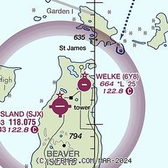
| Sectional chart |
|---|
|
| Airport distance calculator |
|---|
|
|
| Sunrise and sunset |
|---|
|
Times for 23-Aug-2025
| | Local
(UTC-4) | | Zulu
(UTC) |
|---|
| Morning civil twilight | | 06:21 | | 10:21 |
| Sunrise | | 06:53 | | 10:53 |
| Sunset | | 20:36 | | 00:36 |
| Evening civil twilight | | 21:08 | | 01:08 |
|
| Current date and time |
|---|
| Zulu (UTC) | 23-Aug-2025 12:09:22 |
|---|
| Local (UTC-4) | 23-Aug-2025 08:09:22 |
|---|
|
| METAR |
|---|
KSJX
2nm SW | 231155Z AUTO VRB04KT 10SM CLR 20/18 A2977 RMK AO2 10215 20187 70004
|
|
| TAF |
|---|
KPLN
32nm E | 230926Z 2309/2406 23008KT 6SM -SHRA BKN018 OVC035 FM231400 28009G19KT P6SM VCSH BKN035
|
|
| NOTAMs |
|---|
NOTAMs are issued by the DoD/FAA and will open in a separate window not controlled by AirNav.
|
|

