FAA INFORMATION EFFECTIVE 14 MAY 2026
Location
| FAA Identifier: | SJX |
| Lat/Long: | 45-41-32.0000N 085-33-59.8000W
45-41.533333N 085-33.996667W
45.6922222,-85.5666111
(estimated) |
| Elevation: | 669.8 ft. / 204.2 m (surveyed) |
| Variation: | 05W (1995) |
| From city: | 4 miles SW of BEAVER ISLAND, MI |
| Time zone: | UTC -4 (UTC -5 during Standard Time) |
| Zip code: | 49782 |
Airport Operations
| Airport use: | Open to the public |
| Activation date: | 07/1944 |
| Control tower: | no |
| ARTCC: | MINNEAPOLIS CENTER |
| FSS: | LANSING FLIGHT SERVICE STATION |
| NOTAMs facility: | SJX (NOTAM-D service available) |
| Attendance: | 0800-1700
UNATNDD THANKSGIVING & CHRISTMAS. |
| Wind indicator: | lighted |
| Segmented circle: | yes |
| Lights: | ACTVT REIL RWY 09 & 27; PAPI RWY 09 & 27; MIRL RWY 09/27 - CTAF. |
| Beacon: | white-green (lighted land airport)
Operates sunset to sunrise. |
Airport Communications
| CTAF/UNICOM: | 122.8 |
| WX AWOS-3P: | 118.075 (231-448-3081) |
- APCH/DEP SVC PRVDD BY MINNEAPOLIS ARTCC ON FREQS 134.6/354.05 (PELLSTON RCAG).
Nearby radio navigation aids
| VOR radial/distance | | VOR name | | Freq | | Var |
|---|
| PLNr282/38.0 | | PELLSTON VORTAC | | 111.80 | | 06W |
Airport Services
| Fuel available: | 100LL |
| Parking: | tiedowns |
| Airframe service: | NONE |
| Powerplant service: | NONE |
| Bottled oxygen: | NONE |
| Bulk oxygen: | NONE |
Runway Information
Runway 9/27
| Dimensions: | 4299 x 75 ft. / 1310 x 23 m |
| Surface: | asphalt, in good condition |
| Runway edge lights: | medium intensity |
| RUNWAY 9 | | RUNWAY 27 |
| Latitude: | 45-41.493128N | | 45-41.483850N |
| Longitude: | 085-34.662907W | | 085-33.653670W |
| Elevation: | 669.7 ft. | | 667.3 ft. |
| Traffic pattern: | left | | left |
| Runway heading: | 096 magnetic, 091 true | | 276 magnetic, 271 true |
| Markings: | nonprecision, in fair condition | | nonprecision, in fair condition |
| Visual slope indicator: | 4-light PAPI on left (3.00 degrees glide path) | | 4-light PAPI on left (4.00 degrees glide path) |
| Runway end identifier lights: | yes | | yes |
| Touchdown point: | yes, no lights | | yes, no lights |
| Obstructions: | none | | 67 ft. tree, 1010 ft. from runway, 330 ft. right of centerline, 12:1 slope to clear |
Runway 14/32
| Dimensions: | 3278 x 120 ft. / 999 x 37 m |
| Surface: | turf, in good condition |
| Runway edge markings: | 3 FT YELLOW CONES; DTHR MKD WITH 3 CONES EACH SIDE. |
| Operational restrictions: | CLSD NOV-APR & WHEN SNOW COVD. |
| RUNWAY 14 | | RUNWAY 32 |
| Latitude: | 45-41.715445N | | 45-41.349053N |
| Longitude: | 085-34.071692W | | 085-33.507067W |
| Elevation: | 666.3 ft. | | 668.0 ft. |
| Traffic pattern: | left | | left |
| Runway heading: | 138 magnetic, 133 true | | 318 magnetic, 313 true |
| Displaced threshold: | 522 ft. | | 571 ft. |
| Touchdown point: | yes, no lights | | yes, no lights |
| Obstructions: | 70 ft. trees, 125 ft. left of centerline
APCH RATIO 6:1 TO DTHR. | | 15 ft. road, 75 ft. from runway, 133 ft. right of centerline, 5:1 slope to clear
APCH RATIO 13:1 TO DTHR. |
Runway 5/23
| Dimensions: | 2054 x 120 ft. / 626 x 37 m |
| Surface: | turf, in good condition |
| Runway edge markings: | 3 FT YELLOW CONES; DTHR MKD WITH 3 CONES EACH SIDE. |
| Operational restrictions: | CLSD NOV-APR & WHEN SNOW COVD. |
| RUNWAY 5 | | RUNWAY 23 |
| Latitude: | 45-41.509102N | | 45-41.749783N |
| Longitude: | 085-34.161110W | | 085-33.822402W |
| Elevation: | 665.5 ft. | | 664.9 ft. |
| Traffic pattern: | left | | left |
| Runway heading: | 050 magnetic, 045 true | | 230 magnetic, 225 true |
| Displaced threshold: | no | | 763 ft. |
| Runway end identifier lights: | no | | no |
| Touchdown point: | yes, no lights | | yes, no lights |
| Obstructions: | 82 ft. trees, 1238 ft. from runway, 15:1 slope to clear | | 49 ft. trees, 230 ft. from runway, 130 ft. left of centerline, 4:1 slope to clear
APCH RATIO 17:1 TO DTHR. |
Airport Ownership and Management from official FAA records
| Ownership: | Publicly-owned |
| Owner: | ST JAMES & PEAINE TOWNSHIPS
BEAVER ISLAND AIRPORT
BEAVER ISLAND, MI 49782
Phone 231-448-2750 |
| Manager: | RACHEL TEAGUE
PO BOX 134
BEAVER ISLAND, MI 49782-0134
Phone 231-237-9482
CELL 231-675-5391. |
Additional Remarks
| - | DEER & BIRDS ON & INVOF ARPT. |
| - | FOR CD CTC MINNEAPOLIS ARTCC AT 651-463-5588. |
Instrument Procedures
NOTE: All procedures below are presented as PDF files. If you need a reader for these files, you should download the free Adobe Reader.NOT FOR NAVIGATION. Please procure official charts for flight.
FAA instrument procedures published for use from 14 May 2026 at 0901Z to 11 June 2026 at 0900Z.
IAPs - Instrument Approach Procedures |
|---|
| RNAV (GPS) RWY 09 | |
download (186KB) |
| RNAV (GPS) RWY 27 | |
download (240KB) |
| NOTE: Special Alternate Minimums apply | |
download (139KB) |
| NOTE: Special Take-Off Minimums/Departure Procedures apply | |
download (122KB) |
Other nearby airports with instrument procedures:
KCVX - Charlevoix Municipal Airport (26 nm SE)
KISQ - Schoolcraft County Airport (30 nm NW)
KMGN - Harbor Springs Airport (32 nm SE)
KPLN - Pellston Regional/Emmet County Airport (33 nm E)
83D - Mackinac County Airport (37 nm E)
|
|

Road maps at:
MapQuest
Bing
Google
| Aerial photo |
|---|
WARNING: Photo may not be current or correct
 Taken early September 2005
Do you have a better or more recent aerial photo of Beaver Island Airport that you would like to share? If so, please send us your photo.
|
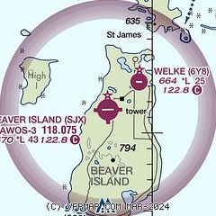
| Sectional chart |
|---|
|
| Airport distance calculator |
|---|
|
|
| Sunrise and sunset |
|---|
|
Times for 04-Jun-2026
| | Local
(UTC-4) | | Zulu
(UTC) |
|---|
| Morning civil twilight | | 05:18 | | 09:18 |
| Sunrise | | 05:56 | | 09:56 |
| Sunset | | 21:26 | | 01:26 |
| Evening civil twilight | | 22:03 | | 02:03 |
|
| Current date and time |
|---|
| Zulu (UTC) | 04-Jun-2026 11:13:17 |
|---|
| Local (UTC-4) | 04-Jun-2026 07:13:17 |
|---|
|
| METAR |
|---|
| KSJX | 041055Z AUTO 23009G15KT 10SM CLR 16/04 A3011 RMK AO2
|
|
| TAF |
|---|
KPLN
33nm E | 040521Z 0406/0506 VRB03KT P6SM SCT250 FM041000 21006KT P6SM SCT250 FM041400 24010G20KT P6SM SCT200 FM050100 22005KT P6SM BKN100
|
|
| NOTAMs |
|---|
NOTAMs are issued by the DoD/FAA and will open in a separate window not controlled by AirNav.
|
|

