FAA INFORMATION EFFECTIVE 14 MAY 2026
Location
| FAA Identifier: | 70J |
| Lat/Long: | 30-53-16.7000N 084-09-17.0000W
30-53.278333N 084-09.283333W
30.8879722,-84.1547222
(estimated) |
| Elevation: | 263.7 ft. / 80.4 m (surveyed) |
| Variation: | 04W (2010) |
| From city: | 3 miles E of CAIRO, GA |
| Time zone: | UTC -4 (UTC -5 during Standard Time) |
| Zip code: | 31728 |
Airport Operations
| Airport use: | Open to the public |
| Activation date: | 01/1947 |
| Control tower: | no |
| ARTCC: | JACKSONVILLE CENTER |
| FSS: | MACON FLIGHT SERVICE STATION |
| NOTAMs facility: | MCN (NOTAM-D service available) |
| Attendance: | MON-FRI 0900-1600 |
| Wind indicator: | lighted |
| Segmented circle: | yes |
| Lights: | MIRL RY 13/31 AND PAPI RYS 13 & 31 OPER CONT DUSK-0000; AFTER 0000 ACTVT - CTAF. |
| Beacon: | white-green (lighted land airport)
Operates sunset to sunrise. |
Airport Communications
| CTAF/UNICOM: | 122.7 |
| TALLAHASSEE APPROACH: | 128.7 [0645-2300] |
| TALLAHASSEE DEPARTURE: | 128.7 [0645-2300] |
| WX AWOS-3PT at TVI (14 nm E): | 119.175 (229-225-4336) |
| WX AWOS-3T at CXU (20 nm N): | 118.675 (229-336-0744) |
- APCH/DEP SVC PRVDD BY JACKSONVILLE ARTCC ON FREQS 128.625/379.175 (TALLAHASSEE RCAG) WHEN TALLAHASSEE APCH CTL CLSD.
Nearby radio navigation aids
| VOR radial/distance | | VOR name | | Freq | | Var |
|---|
| SZWr028/22.9 | | SEMINOLE VORTAC | | 117.50 | | 02E |
| GEFr316/27.8 | | GREENVILLE VORTAC | | 113.65 | | 01E |
| NDB name | | Hdg/Dist | | Freq | | Var | | ID |
|---|
| CAIDY | | at field | | 338 | | 04W | | CYR | -.-. -.-- .-. |
| WILLIS | | 109/19.7 | | 359 | | 04W | | LYZ | .-.. -.-- --.. |
Airport Services
| Fuel available: | 100LL
100LL:FUEL AVAILABLE DURING ATTENDED HOURS |
| Parking: | tiedowns |
| Airframe service: | MAJOR |
| Powerplant service: | MAJOR |
| Bottled oxygen: | NONE |
| Bulk oxygen: | NONE |
Runway Information
Runway 13/31
| Dimensions: | 4000 x 75 ft. / 1219 x 23 m |
| Surface: | asphalt, in good condition |
| Weight bearing capacity: | |
| Runway edge lights: | medium intensity |
| RUNWAY 13 | | RUNWAY 31 |
| Latitude: | 30-53.446492N | | 30-53.110713N |
| Longitude: | 084-09.613343W | | 084-08.954793W |
| Elevation: | 263.6 ft. | | 236.2 ft. |
| Traffic pattern: | left | | left |
| Runway heading: | 125 magnetic, 121 true | | 305 magnetic, 301 true |
| Markings: | nonprecision, in good condition | | nonprecision, in good condition |
| Visual slope indicator: | 2-light PAPI on left (3.50 degrees glide path) | | 2-light PAPI on left (3.00 degrees glide path) |
| Touchdown point: | yes, no lights | | yes, no lights |
| Obstructions: | 20 ft. trees, 520 ft. from runway, 125 ft. right of centerline, 16:1 slope to clear | | 8 ft. trees, 240 ft. from runway, 242 ft. right of centerline, 5:1 slope to clear |
Airport Ownership and Management from official FAA records
| Ownership: | Publicly-owned |
| Owner: | CITY OF CAIRO
BOX 29
CAIRO, GA 39828
Phone 229-377-1722 |
| Manager: | BOOKER GAINOR, CITY MGR
PO BOX 29, 259 EDNA LANE
CAIRO, GA 39828
Phone 229-327-1114 |
Additional Remarks
| - | FOR CD CTC TALLAHASSEE APCH AT 850-942-8311, WHEN APCH CLSD CTC JACKSONVILLE ARTCC AT 904-845-1592. |
Instrument Procedures
NOTE: All procedures below are presented as PDF files. If you need a reader for these files, you should download the free Adobe Reader.NOT FOR NAVIGATION. Please procure official charts for flight.
FAA instrument procedures published for use from 14 May 2026 at 0901Z to 11 June 2026 at 0900Z.
IAPs - Instrument Approach Procedures |
|---|
| RNAV (GPS) RWY 13 | |
download (231KB) |
| RNAV (GPS) RWY 31 | |
download (241KB) |
| NOTE: Special Take-Off Minimums/Departure Procedures apply | |
download (189KB) |
Other nearby airports with instrument procedures:
KTVI - Thomasville Regional Airport (14 nm E)
KCXU - Camilla-Mitchell County Airport (20 nm N)
KMGR - Moultrie Municipal Airport (22 nm NE)
KBGE - Decatur County Industrial Air Park (25 nm W)
2J9 - Quincy Municipal Airport (27 nm SW)
|
|

Road maps at:
MapQuest
Bing
Google
| Aerial photo |
|---|
WARNING: Photo may not be current or correct
 Photo courtesy of AirNav, LLC
Photo taken 03-Feb-2013
looking east.
Photo courtesy of AirNav, LLC
Photo taken 03-Feb-2013
looking east.
Do you have a better or more recent aerial photo of Cairo-Grady County Airport that you would like to share? If so, please send us your photo.
|
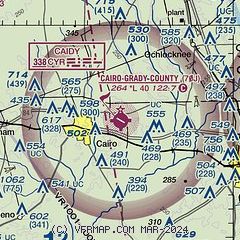
| Sectional chart |
|---|
|
| Airport distance calculator |
|---|
|
|
| Sunrise and sunset |
|---|
|
Times for 10-Jun-2026
| | Local
(UTC-4) | | Zulu
(UTC) |
|---|
| Morning civil twilight | | 06:06 | | 10:06 |
| Sunrise | | 06:34 | | 10:34 |
| Sunset | | 20:38 | | 00:38 |
| Evening civil twilight | | 21:06 | | 01:06 |
|
| Current date and time |
|---|
| Zulu (UTC) | 10-Jun-2026 04:19:33 |
|---|
| Local (UTC-4) | 10-Jun-2026 00:19:33 |
|---|
|
| METAR |
|---|
KTVI
14nm E | 100355Z AUTO 00000KT 10SM CLR 23/22 A3012 RMK AO2
|
KCXU
20nm N | 100355Z AUTO 00000KT 10SM CLR 23/23 A3011 RMK AO2 403030232
|
KBGE
25nm W | 100355Z AUTO 00000KT 10SM CLR 24/19 A3010 RMK AO2 T02390193
|
K2J9
27nm SW | 100355Z AUTO 00000KT 10SM CLR 25/24 A3011 RMK AO2
|
|
| TAF |
|---|
KTLH
31nm S | 091720Z 0918/1018 VRB04KT P6SM VCSH SCT060 BKN150 FM100100 00000KT P6SM FEW150
|
|
| NOTAMs |
|---|
NOTAMs are issued by the DoD/FAA and will open in a separate window not controlled by AirNav.
|
|


