FAA INFORMATION EFFECTIVE 19 FEBRUARY 2026
Location
| FAA Identifier: | 7T0 |
| Lat/Long: | 33-35-37.0000N 097-13-08.0000W
33-35.616667N 097-13.133333W
33.5936111,-97.2188889
(estimated) |
| Elevation: | 885 ft. / 270 m (estimated) |
| Variation: | 07E (1985) |
| From city: | 3 miles S of LINDSAY, TX |
| Time zone: | UTC -6 (UTC -5 during Daylight Saving Time) |
| Zip code: | 76240 |
Airport Operations
| Airport use: | Open to the public |
| Activation date: | 06/1979 |
| Control tower: | no |
| ARTCC: | FORT WORTH CENTER |
| FSS: | FORT WORTH FLIGHT SERVICE STATION |
| NOTAMs facility: | FTW (NOTAM-D service available) |
| Attendance: | UNATNDD |
| Wind indicator: | yes |
| Segmented circle: | no |
Airport Communications
| CTAF: | 122.9 |
| WX AWOS-3 at GLE (4 nm N): | 118.375 (940-612-3549) |
Nearby radio navigation aids
| VOR radial/distance | | VOR name | | Freq | | Var |
|---|
| UKWr077/30.3 | | BOWIE VORTAC | | 117.15 | | 06E |
| ADMr178/37.2 | | ARDMORE VORTAC | | 116.70 | | 06E |
| NDB name | | Hdg/Dist | | Freq | | Var | | ID |
|---|
| DENISON | | 240/30.8 | | 341 | | 03E | | DNI | -.. -. .. |
Airport Services
Runway Information
Runway 17/35
| Dimensions: | 2400 x 60 ft. / 732 x 18 m |
| Surface: | turf, in good condition |
| RUNWAY 17 | | RUNWAY 35 |
| Latitude: | 33-35.815167N | | 33-35.419463N |
| Longitude: | 097-13.126958W | | 097-13.138415W |
| Elevation: | 881.0 ft. | | 879.0 ft. |
| Traffic pattern: | right | | left |
| Runway heading: | 174 magnetic, 181 true | | 354 magnetic, 001 true |
| Obstructions: | 15 ft. road, 25 ft. from runway, 125 ft. left and right of centerline, 1:1 slope to clear | | 15 ft. road, 50 ft. from runway, 125 ft. left and right of centerline, 3:1 slope to clear |
Airport Ownership and Management from official FAA records
| Ownership: | Privately-owned |
| Owner: | FREEDOM FIELD INC
BOX 160
LINDSAY, TX 76252
Phone 940-736-6464 |
| Manager: | TOM SCHAD
2961 FM 1630
GAINESVILLE, TX 76240
Phone 940-736-6464 |
Additional Remarks
| - | OCNL LIVESTOCK ON RWY. |
| - | RWY 17, 40 FT POLE, 55 FT DSTC, 90 FT L, 200 FT R. LINES BURIED UNDER APCH. |
| - | NO STUDENT TFC, NO HELS. |
| - | RWY SOFT AFT RAIN. CALL TO CFM COND. |
| - | FOR CD CTC FORT WORTH ARTCC AT 817-858-7584. |
| - | RWY 35, 34 FT POLE, 20 FT DSTC, 230 FT L, 130 R. LINES BURIED UNDER APCH. |
Instrument Procedures
There are no published instrument procedures at 7T0.
Some nearby airports with instrument procedures:
KGLE - Gainesville Municipal Airport (4 nm N)
KDTO - Denton Enterprise Airport (24 nm S)
KLUD - Decatur Municipal Airport (27 nm SW)
0F2 - Bowie Municipal Airport (28 nm W)
KGYI - North Texas Regional Airport/Perrin Field (28 nm E)
|
|

Road maps at:
MapQuest
Bing
Google
| Aerial photo |
|---|
WARNING: Photo may not be current or correct

Do you have a better or more recent aerial photo of Freedom Field Airport that you would like to share? If so, please send us your photo.
|
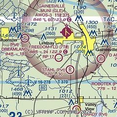
| Sectional chart |
|---|
|
| Airport distance calculator |
|---|
|
|
| Sunrise and sunset |
|---|
|
Times for 17-Mar-2026
| | Local
(UTC-5) | | Zulu
(UTC) |
|---|
| Morning civil twilight | | 07:13 | | 12:13 |
| Sunrise | | 07:38 | | 12:38 |
| Sunset | | 19:37 | | 00:37 |
| Evening civil twilight | | 20:02 | | 01:02 |
|
| Current date and time |
|---|
| Zulu (UTC) | 18-Mar-2026 04:33:24 |
|---|
| Local (UTC-5) | 17-Mar-2026 23:33:24 |
|---|
|
| METAR |
|---|
KGLE
4nm N | 180415Z AUTO 17005KT 10SM CLR 10/M04 A3012 RMK AO2 T00991037
|
|
| TAF |
|---|
KAFW
38nm S | 180256Z 1803/1824 17012KT P6SM SCT250 FM181500 20014KT P6SM SCT250
|
KDFW
43nm S | 180256Z 1803/1906 17012KT P6SM SCT250 FM181500 20015KT P6SM SCT250 FM190100 18008KT P6SM FEW250
|
KDUA
46nm NE | 171720Z 1718/1818 20014G24KT P6SM BKN250 FM180000 18010KT P6SM BKN250 FM180500 19010KT P6SM FEW100 BKN250 WS020/22045KT FM181200 21010KT P6SM FEW100 BKN250
|
KFTW
46nm S | 180256Z 1803/1824 17012KT P6SM SCT250 FM181500 19015KT P6SM SCT250
|
|
| NOTAMs |
|---|
NOTAMs are issued by the DoD/FAA and will open in a separate window not controlled by AirNav.
|
|


