FAA INFORMATION EFFECTIVE 16 APRIL 2026
Location
| FAA Identifier: | 93Y |
| Lat/Long: | 41-13-49.1870N 097-07-21.1110W
41-13.819783N 097-07.351850W
41.2303297,-97.1225308
(estimated) |
| Elevation: | 1617.7 ft. / 493.1 m (surveyed) |
| Variation: | 05E (2005) |
| From city: | 1 mile S of DAVID CITY, NE |
| Time zone: | UTC -5 (UTC -6 during Standard Time) |
| Zip code: | 68632 |
Airport Operations
| Airport use: | Open to the public |
| Activation date: | 04/1948 |
| Control tower: | no |
| ARTCC: | MINNEAPOLIS CENTER |
| FSS: | COLUMBUS FLIGHT SERVICE STATION |
| NOTAMs facility: | OLU (NOTAM-D service available) |
| Attendance: | UNATNDD |
| Wind indicator: | lighted |
| Segmented circle: | yes |
| Lights: | ACTVT PAPI RWY 14 & 32; MIRL RWY 14/32 - CTAF. |
| Beacon: | white-green (lighted land airport)
Operates sunset to sunrise. |
Airport Communications
| CTAF: | 122.9 |
| OMAHA APPROACH: | 124.0 |
| OMAHA DEPARTURE: | 124.0 |
| WX AWOS-3PT at OLU (16 nm NW): | 125.525 (402-563-3895) |
Nearby radio navigation aids
| VOR radial/distance | | VOR name | | Freq | | Var |
|---|
| OLUr135/16.4 | | COLUMBUS VOR/DME | | 116.95 | | 08E |
| LNKr308/25.2 | | LINCOLN VORTAC | | 116.10 | | 09E |
| SCBr219/31.6 | | SCRIBNER VOR/DME | | 111.00 | | 06E |
| NDB name | | Hdg/Dist | | Freq | | Var | | ID |
|---|
| WAHOO | | 263/23.6 | | 400 | | 06E | | AHQ | .- .... --.- |
| YORK | | 042/30.0 | | 257 | | 06E | | JYR | .--- -.-- .-. |
Airport Services
| Fuel available: | 100LL |
| Parking: | tiedowns |
| Airframe service: | NONE |
| Powerplant service: | NONE |
| Bottled oxygen: | NONE |
| Bulk oxygen: | NONE |
Runway Information
Runway 14/32
| Dimensions: | 3676 x 60 ft. / 1120 x 18 m |
| Surface: | asphalt, in fair condition |
| Weight bearing capacity: | |
| Runway edge lights: | medium intensity |
| RUNWAY 14 | | RUNWAY 32 |
| Latitude: | 41-14.036168N | | 41-13.536928N |
| Longitude: | 097-07.508718W | | 097-07.055540W |
| Elevation: | 1613.1 ft. | | 1616.6 ft. |
| Traffic pattern: | left | | right |
| Runway heading: | 141 magnetic, 146 true | | 321 magnetic, 326 true |
| Displaced threshold: | 74 ft. | | no |
| Declared distances: | TORA:3675 TODA:3675 ASDA:3675 LDA:3600 | | TORA:3675 TODA:3675 ASDA:3675 LDA:3675 |
| Markings: | nonprecision, in good condition | | nonprecision, in good condition |
| Visual slope indicator: | 2-light PAPI on left (3.00 degrees glide path) | | 2-light PAPI on left (3.00 degrees glide path) |
| Runway end identifier lights: | yes | | yes |
| Touchdown point: | yes, no lights | | yes, no lights |
| Obstructions: | 13 ft. road, 422 ft. from runway, 16:1 slope to clear
RWY 14 CLNC SLP 33:1 FOR TREE 1892 FT OUT, 58 FT ABV, 89R. 37:1 FM DSPLCD THLD FOR ROAD. | | none |
Runway 1/19
| Dimensions: | 2114 x 120 ft. / 644 x 37 m |
| Surface: | turf, in fair condition |
| Operational restrictions: | RWY 01/19 NOT PLOWED WINTER MONTHS. |
| RUNWAY 1 | | RUNWAY 19 |
| Latitude: | 41-13.709108N | | 41-14.045990N |
| Longitude: | 097-07.531190W | | 097-07.415033W |
| Elevation: | 1612.4 ft. | | 1613.8 ft. |
| Traffic pattern: | right | | left |
| Runway heading: | 010 magnetic, 015 true | | 190 magnetic, 195 true |
| Touchdown point: | yes, no lights | | yes, no lights |
Airport Ownership and Management from official FAA records
| Ownership: | Publicly-owned |
| Owner: | CITY OF DAVID CITY
P.O. BOX 191
DAVID CITY, NE 68632-0191
Phone 402-367-3135 |
| Manager: | CHRIS KROESING
174 WEST E STREET
DAVID CITY, NE 68632-1531
Phone 402-367-3109
FOR SVCS OR EMERG, CALL 402-367-3109/7400. |
Additional Remarks
| A57-01 | RWY 01 SLOPE 37:1, DUE TO FENCE 4 FT ABV, 148 FT FROM RWY END, 134R. |
| A57-19 | RWY 19 SLOPE 30:1 DUE TO ROAD 14 FT ABV, 420 FT FM RWY END, 0B. |
| - | FOR CD CTC OMAHA APCH AT 402-682-4395. |
| - | FUEL AVBL H24 VIA CREDIT CARD. |
Instrument Procedures
NOTE: All procedures below are presented as PDF files. If you need a reader for these files, you should download the free Adobe Reader.NOT FOR NAVIGATION. Please procure official charts for flight.
FAA instrument procedures published for use from 16 April 2026 at 0901Z to 14 May 2026 at 0900Z.
IAPs - Instrument Approach Procedures |
|---|
| RNAV (GPS) RWY 14 | |
download (211KB) |
| RNAV (GPS) RWY 32 | |
download (211KB) |
| NOTE: Special Take-Off Minimums/Departure Procedures apply | |
download (370KB) |
Other nearby airports with instrument procedures:
KOLU - Columbus Municipal Airport (16 nm NW)
KSWT - Seward Municipal Airport (22 nm S)
KAHQ - Wahoo Municipal Airport (24 nm E)
KLNK - Lincoln Airport (28 nm SE)
KFET - Fremont Municipal Airport (30 nm NE)
|
|

Road maps at:
MapQuest
Bing
Google
| Aerial photo |
|---|
WARNING: Photo may not be current or correct
 Photo by Chase Holoubek
Photo taken 18-Jun-2017
looking southeast.
Photo by Chase Holoubek
Photo taken 18-Jun-2017
looking southeast.
Do you have a better or more recent aerial photo of David City Municipal Airport that you would like to share? If so, please send us your photo.
|
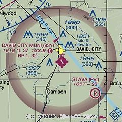
| Sectional chart |
|---|
|
| Airport distance calculator |
|---|
|
|
| Sunrise and sunset |
|---|
|
Times for 22-Apr-2026
| | Local
(UTC-5) | | Zulu
(UTC) |
|---|
| Morning civil twilight | | 06:10 | | 11:10 |
| Sunrise | | 06:39 | | 11:39 |
| Sunset | | 20:15 | | 01:15 |
| Evening civil twilight | | 20:44 | | 01:44 |
|
| Current date and time |
|---|
| Zulu (UTC) | 22-Apr-2026 18:11:23 |
|---|
| Local (UTC-5) | 22-Apr-2026 13:11:23 |
|---|
|
| METAR |
|---|
KOLU
16nm NW | 221756Z AUTO 17017G26KT 10SM CLR 24/15 A2982 RMK AO2 PK WND 18026/1748 SLP091 T02440150 10244 20144 58018
|
KAHQ
24nm E | 221755Z AUTO 16019G26KT 10SM CLR 25/13 A2986 RMK AO2 6//// T02490129
|
KLNK
29nm SE | 221754Z 17015G22KT 10SM CLR 25/13 A2987 RMK AO2 SLP104 T02500133 10250 20161 58013
|
KJYR
30nm SW | 221755Z AUTO 18017KT 10SM CLR 25/14 A2983 RMK AO2
|
KFET
30nm NE | 221755Z AUTO 17015G20KT 10SM CLR 25/13 A2986 RMK AO2 T02480134 10248 20148
|
|
| TAF |
|---|
KLNK
29nm SE | 221720Z 2218/2318 18018G28KT P6SM SKC FM230500 17018G30KT P6SM BKN020 FM230800 18016G27KT P6SM OVC016
|
|
| NOTAMs |
|---|
NOTAMs are issued by the DoD/FAA and will open in a separate window not controlled by AirNav.
|
|

