FAA INFORMATION EFFECTIVE 14 MAY 2026
Location
| FAA Identifier: | 99N |
| Lat/Long: | 33-18-16.3000N 081-06-30.3000W
33-18.271667N 081-06.505000W
33.3045278,-81.1084167
(estimated) |
| Elevation: | 231 ft. / 70 m (estimated) |
| Variation: | 07W (2010) |
| From city: | 5 miles W of BAMBERG, SC |
| Time zone: | UTC -4 (UTC -5 during Standard Time) |
| Zip code: | 29042 |
Airport Operations
| Airport use: | Open to the public |
| Activation date: | 10/1982 |
| Control tower: | no |
| ARTCC: | JACKSONVILLE CENTER |
| FSS: | ANDERSON FLIGHT SERVICE STATION |
| NOTAMs facility: | AND (NOTAM-D service available) |
| Attendance: | UNATNDD |
| Wind indicator: | yes |
| Segmented circle: | yes |
| Lights: | ACTVT PAPI RWY 05 & 23; MIRL RWY 05/23 - CTAF. |
| Beacon: | white-green (lighted land airport)
Operates sunset to sunrise. |
Airport Communications
| CTAF/UNICOM: | 122.8 |
| COLUMBIA APPROACH: | 124.15 [SUN-FRI 0530-0030 SAT 0530-0000] |
| COLUMBIA DEPARTURE: | 124.15 [SUN-FRI 0530-0030 SAT 0530-0000] |
| WX AWOS-3PT at BNL (14 nm W): | 119.775 (803-259-4536) |
| WX ASOS at OGB (15 nm NE): | 118.525 (803-536-3901) |
- APCH/DEP SVC PRVDD BY COLUMBIA APCH CTL ON FREQS 124.15/338.2
Nearby radio navigation aids
| VOR radial/distance | | VOR name | | Freq | | Var |
|---|
| ALDr029/(19.8) | | ALLENDALE VOR | | 116.70 | | 01W |
| CAEr187/33.3 | | COLUMBIA VORTAC | | 114.70 | | 02W |
| NDB name | | Hdg/Dist | | Freq | | Var | | ID |
|---|
| AIKEN | | 132/35.3 | | 347 | | 06W | | AIK | .- .. -.- |
Airport Services
| Fuel available: | 100LL |
| Parking: | tiedowns |
| Airframe service: | NONE |
| Powerplant service: | NONE |
| Bottled oxygen: | NONE |
| Bulk oxygen: | NONE |
Runway Information
Runway 5/23
| Dimensions: | 3603 x 60 ft. / 1098 x 18 m |
| Surface: | asphalt, in fair condition |
| Weight bearing capacity: | | Single wheel: | 30.0 | | Double wheel: | 60.0 |
|
| Runway edge lights: | medium intensity |
| RUNWAY 5 | | RUNWAY 23 |
| Latitude: | 33-18.056975N | | 33-18.486865N |
| Longitude: | 081-06.748578W | | 081-06.260402W |
| Elevation: | 208.3 ft. | | 230.7 ft. |
| Traffic pattern: | left | | left |
| Runway heading: | 051 magnetic, 044 true | | 231 magnetic, 224 true |
| Markings: | nonprecision, in fair condition | | nonprecision, in fair condition |
| Visual slope indicator: | 2-light PAPI on left (3.00 degrees glide path) | | 2-light PAPI on left (3.00 degrees glide path) |
| Touchdown point: | yes, no lights | | yes, no lights |
| Obstructions: | 78 ft. tree, 559 ft. from runway, 294 ft. left of centerline, 4:1 slope to clear | | 71 ft. tree, 634 ft. from runway, 309 ft. right of centerline, 6:1 slope to clear |
Airport Ownership and Management from official FAA records
| Ownership: | Publicly-owned |
| Owner: | BAMBERG COUNTY
PO BOX 149
BAMBERG, SC 29003
Phone 803-245-5191 |
| Manager: | MR. JOEY PRESTON
PO BOX 149
BAMBERG, SC 29003
Phone 803-245-5191
COUNTY ADMINISTRATOR. |
Additional Remarks
| - | FOR CD CTC COLUMBIA APCH AT 803-822-5242 OR 803-822-5040. |
Instrument Procedures
NOTE: All procedures below are presented as PDF files. If you need a reader for these files, you should download the free Adobe Reader.NOT FOR NAVIGATION. Please procure official charts for flight.
FAA instrument procedures published for use from 14 May 2026 at 0901Z to 11 June 2026 at 0900Z.
IAPs - Instrument Approach Procedures |
|---|
| RNAV (GPS) RWY 05 **CHANGED** | |
download (195KB) |
| RNAV (GPS) RWY 23 | |
download (182KB) |
| NOTE: Special Take-Off Minimums/Departure Procedures apply | |
download (365KB) |
Other nearby airports with instrument procedures:
KBNL - Barnwell Regional Airport (14 nm W)
KOGB - Orangeburg Municipal Airport (15 nm NE)
KXNO - North Air Force Auxiliary Field (18 nm N)
KAQX - Allendale County Airport (20 nm SW)
6J0 - Lexington County Airport (30 nm N)
|
|

Road maps at:
MapQuest
Bing
Google
| Aerial photo |
|---|
WARNING: Photo may not be current or correct

Do you have a better or more recent aerial photo of Bamberg County Airport that you would like to share? If so, please send us your photo.
|
| Sectional chart |
|---|
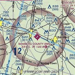
|
| Airport distance calculator |
|---|
|
|
| Sunrise and sunset |
|---|
|
Times for 07-Jun-2026
| | Local
(UTC-4) | | Zulu
(UTC) |
|---|
| Morning civil twilight | | 05:47 | | 09:47 |
| Sunrise | | 06:16 | | 10:16 |
| Sunset | | 20:31 | | 00:31 |
| Evening civil twilight | | 20:59 | | 00:59 |
|
| Current date and time |
|---|
| Zulu (UTC) | 07-Jun-2026 14:38:10 |
|---|
| Local (UTC-4) | 07-Jun-2026 10:38:10 |
|---|
|
| METAR |
|---|
KBNL
14nm W | 071415Z AUTO 19004KT 10SM CLR 27/20 A3008 RMK AO2
|
KOGB
16nm NE | 071353Z AUTO 25009KT 10SM CLR 26/19 A3008 RMK AO2 SLP182 T02610194
|
KXNO
18nm N | 071355Z AUTO 20007KT 10SM CLR 26/20 A3005 RMK AO2 SLP176 T02630199 $
|
KAQX
20nm SW | 071415Z AUTO 00000KT 10SM CLR 26/20 A3007 RMK AO2
|
|
| TAF |
|---|
KOGB
16nm NE | 071136Z 0712/0812 VRB03KT P6SM SCT250 FM071500 24007KT P6SM FEW050 SCT250 FM080100 23003KT P6SM BKN250
|
|
| NOTAMs |
|---|
NOTAMs are issued by the DoD/FAA and will open in a separate window not controlled by AirNav.
|
|


