FAA INFORMATION EFFECTIVE 19 FEBRUARY 2026
Location
| FAA Identifier: | BNL |
| Lat/Long: | 33-15-27.6039N 081-23-17.5882W
33-15.460065N 081-23.293137W
33.2576678,-81.3882189
(estimated) |
| Elevation: | 246.3 ft. / 75.1 m (surveyed) |
| Variation: | 05W (1990) |
| From city: | 1 mile NW of BARNWELL, SC |
| Time zone: | UTC -5 (UTC -4 during Daylight Saving Time) |
| Zip code: | 29812 |
Airport Operations
| Airport use: | Open to the public |
| Activation date: | 05/1943 |
| Control tower: | no |
| ARTCC: | JACKSONVILLE CENTER |
| FSS: | ANDERSON FLIGHT SERVICE STATION |
| NOTAMs facility: | AND (NOTAM-D service available) |
| Attendance: | 0900-1700 |
| Wind indicator: | lighted |
| Segmented circle: | yes |
| Lights: | ACTVT ODALS RWY 17; MIRL RWY 17/35 - CTAF. PAPI RWY 17 & 35 OPER CONSLY, OTR TIMES - CTAF. |
| Beacon: | white-green (lighted land airport)
Operates sunset to sunrise. |
Airport Communications
| CTAF/UNICOM: | 122.8 |
| WX AWOS-3PT: | 119.775 (803-259-4536) |
| WX AWOS-3PT at AQX (17 nm S): | 118.950 (803-584-3696) |
- APCH/DEP SVC PRVDD BY JACKSONVILLE ARTCC ON FREQS 132.925/363.2 (MILLEN RCAG).
Nearby radio navigation aids
| VOR radial/distance | | VOR name | | Freq | | Var |
|---|
| ALDr343/(15.5) | | ALLENDALE VOR | | 116.70 | | 01W |
| CAEr207/39.7 | | COLUMBIA VORTAC | | 114.70 | | 02W |
| NDB name | | Hdg/Dist | | Freq | | Var | | ID |
|---|
| AIKEN | | 155/27.7 | | 347 | | 06W | | AIK | .- .. -.- |
| EMORY | | 116/32.9 | | 385 | | 04W | | EMR | . -- .-. |
Airport Services
| Fuel available: | 100LL JET-A MOGAS
100LL:FUEL 24 HR CREDIT CARD SVC AVBL. EMERG FUEL SHUTOFF LCTD ON RIGHT SIDE OF TRML BLDG ATCHD TO ELECL VAULT. |
| Parking: | hangars and tiedowns |
| Airframe service: | NONE |
| Powerplant service: | NONE |
| Bottled oxygen: | NONE |
| Bulk oxygen: | NONE |
Runway Information
Runway 17/35
| Dimensions: | 5119 x 100 ft. / 1560 x 30 m |
| Surface: | asphalt, in good condition |
| Weight bearing capacity: | | PCN 26 /F/B/X/T | | Single wheel: | 69.0 | | Double wheel: | 99.0 |
|
| Runway edge lights: | medium intensity |
| RUNWAY 17 | | RUNWAY 35 |
| Latitude: | 33-15.873225N | | 33-15.077967N |
| Longitude: | 081-23.230133W | | 081-22.893528W |
| Elevation: | 236.6 ft. | | 245.1 ft. |
| Traffic pattern: | right | | left |
| Runway heading: | 165 magnetic, 160 true | | 345 magnetic, 340 true |
| Markings: | nonprecision, in good condition | | nonprecision, in good condition |
| Visual slope indicator: | 2-light PAPI on left (3.04 degrees glide path) | | 2-light PAPI on left (3.00 degrees glide path) |
| Approach lights: | ODALS: omnidirectional approach lighting system | | |
| Runway end identifier lights: | no | | no |
| Touchdown point: | yes, no lights | | yes, no lights |
| Obstructions: | 90 ft. tree, 2606 ft. from runway, 455 ft. left of centerline, 26:1 slope to clear
12 FT TREES 247 FT L OF CNTRLN AND 70 FT FROM RWY THR. | | 68 ft. tree, 1374 ft. from runway, 469 ft. left of centerline, 17:1 slope to clear |
Runway 5/23
| Dimensions: | 4526 x 70 ft. / 1380 x 21 m |
| Surface: | asphalt/aggregate friction seal coat, in poor condition
RWY HAS MULT CRACKS AND RAVELING PRODUCING FOD. RWY THRS NOT MKD.
RSTRD USE TO ACFT WEIGHING 12500 AND LESS. |
| Weight bearing capacity: | |
| RUNWAY 5 | | RUNWAY 23 |
| Latitude: | 33-15.180167N | | 33-15.704833N |
| Longitude: | 081-23.870667W | | 081-23.238833W |
| Elevation: | 242.0 ft. | | 240.0 ft. |
| Traffic pattern: | left | | right |
| Runway heading: | 050 magnetic, 045 true | | 230 magnetic, 225 true |
| Markings: | basic, in fair condition | | basic, in fair condition |
| Runway end identifier lights: | no | | no |
| Touchdown point: | yes, no lights | | yes, no lights |
Airport Ownership and Management from official FAA records
| Ownership: | Publicly-owned |
| Owner: | BARNWELL COUNTY
COUNTY COURTHOUSE
BARNWELL, SC 29812
Phone 803-541-1000 |
| Manager: | RICK GRIMES
155 AIRPORT ROAD, PO BOX 899
BARNWELL, SC 29812
Phone 803-300-1190 |
Additional Remarks
| - | GCO AVBL ON FREQ 121.725 THRU ZJX CLEARANCE DELIVERY. |
| - | AEROBATIC ACT WEST OF RWY 17/35. WHEN ACTIVE, INCOMING ACFT APCH ARPT FROM EAST. |
| - | FOR CD IF UNA VIA GCO CTC JACKSONVILLE ARTCC AT 904-845-1592. |
Instrument Procedures
NOTE: All procedures below are presented as PDF files. If you need a reader for these files, you should download the free Adobe Reader.NOT FOR NAVIGATION. Please procure official charts for flight.
FAA instrument procedures published for use from 19 February 2026 at 0901Z to 19 March 2026 at 0900Z.
IAPs - Instrument Approach Procedures |
|---|
| RNAV (GPS) RWY 17 | |
download (221KB) |
| RNAV (GPS) RWY 35 | |
download (231KB) |
| NOTE: Special Take-Off Minimums/Departure Procedures apply | |
download (141KB) |
Other nearby airports with instrument procedures:
99N - Bamberg County Airport (14 nm E)
KAQX - Allendale County Airport (17 nm S)
KXNO - North Air Force Auxiliary Field (26 nm NE)
KAIK - Aiken Regional Airport (28 nm NW)
KOGB - Orangeburg Municipal Airport (29 nm NE)
|
|

Road maps at:
MapQuest
Bing
Google
| Aerial photo |
|---|
WARNING: Photo may not be current or correct
 Photo by Dave Fogarty DPE/ATP/CFI/A&P-IA/FAAST
Photo taken 09-Jan-2019
looking west from 8,000 MSL
Photo by Dave Fogarty DPE/ATP/CFI/A&P-IA/FAAST
Photo taken 09-Jan-2019
looking west from 8,000 MSL
Do you have a better or more recent aerial photo of Barnwell Regional Airport that you would like to share? If so, please send us your photo.
|
| Sectional chart |
|---|
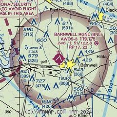
|
| Airport distance calculator |
|---|
|
|
| Sunrise and sunset |
|---|
|
Times for 10-Mar-2026
| | Local
(UTC-4) | | Zulu
(UTC) |
|---|
| Morning civil twilight | | 07:19 | | 11:19 |
| Sunrise | | 07:44 | | 11:44 |
| Sunset | | 19:28 | | 23:28 |
| Evening civil twilight | | 19:53 | | 23:53 |
|
| Current date and time |
|---|
| Zulu (UTC) | 10-Mar-2026 15:47:15 |
|---|
| Local (UTC-4) | 10-Mar-2026 11:47:15 |
|---|
|
| METAR |
|---|
| KBNL | 101515Z AUTO 10SM FEW090 23/16 A3018 RMK AO2
|
KAQX
17nm S | 101515Z AUTO 00000KT 10SM FEW024 FEW100 23/18 A3018 RMK AO2
|
|
| TAF |
|---|
KAGS
30nm W | 101120Z 1012/1112 VRB03KT P6SM FEW050 FM101600 26009KT P6SM SCT050 SCT120 FM110000 VRB03KT P6SM SCT250
|
KOGB
30nm NE | 101120Z 1012/1112 VRB03KT P6SM SCT070 BKN120 FM101500 25009KT P6SM SCT050 SCT120 FM110000 VRB03KT P6SM SCT250
|
|
| NOTAMs |
|---|
NOTAMs are issued by the DoD/FAA and will open in a separate window not controlled by AirNav.
|
|

