FAA INFORMATION EFFECTIVE 09 JULY 2026
Location
| FAA Identifier: | OGB |
| Lat/Long: | 33-27-24.9041N 080-51-33.8640W
33-27.415068N 080-51.564400W
33.4569178,-80.8594067
(estimated) |
| Elevation: | 195.4 ft. / 59.6 m (surveyed) |
| Variation: | 07W (2010) |
| From city: | 2 miles S of ORANGEBURG, SC |
| Time zone: | UTC -4 (UTC -5 during Standard Time) |
| Zip code: | 29115 |
Airport Operations
| Airport use: | Open to the public |
| Activation date: | 11/1937 |
| Control tower: | no |
| ARTCC: | JACKSONVILLE CENTER |
| FSS: | ANDERSON FLIGHT SERVICE STATION |
| NOTAMs facility: | OGB (NOTAM-D service available) |
| Attendance: | MON-FRI 0700-1700
NOT MANNED ON SAT OR SUN - FOR ASST PHONE AMGR. |
| Wind indicator: | lighted |
| Segmented circle: | yes |
| Lights: | ACTVT ODALS RWY 17/35, REIL RWY 23 & RWY 17/35; MIRL RWY 05/23 & RWY 17/35 - CTAF. PAPI RWY 17 & 35 OPER CONSLY. |
| Beacon: | white-green (lighted land airport)
Operates sunset to sunrise. |
Airport Communications
| CTAF/UNICOM: | 122.7 |
| WX ASOS: | 118.525 (803-536-3901) |
| COLUMBIA APPROACH: | 124.15 |
| COLUMBIA DEPARTURE: | 124.15 |
- APCH/DEP SVC PRVDD BY CAE (COLUMBIA METROPOLITAN, COLUMBIA SC) 124.15/338.2.
Nearby radio navigation aids
| VOR radial/distance | | VOR name | | Freq | | Var |
|---|
| CAEr160/25.9 | | COLUMBIA VORTAC | | 114.70 | | 02W |
| MMTr194/28.2 | | MC ENTIRE VORTAC | | 113.20 | | 08W |
| ALDr040/(34.4) | | ALLENDALE VOR | | 116.70 | | 01W |
Airport Services
| Fuel available: | 100LL JET-A |
| Parking: | tiedowns |
| Airframe service: | MINOR |
| Powerplant service: | MINOR |
| Bottled oxygen: | NONE |
| Bulk oxygen: | NONE |
Runway Information
Runway 17/35
| Dimensions: | 5399 x 100 ft. / 1646 x 30 m |
| Surface: | asphalt, in good condition |
| Weight bearing capacity: | | Single wheel: | 30.0 | | Double wheel: | 72.0 |
|
| Runway edge lights: | medium intensity |
| RUNWAY 17 | | RUNWAY 35 |
| Latitude: | 33-27.646643N | | 33-26.778167N |
| Longitude: | 080-51.706032W | | 080-51.472348W |
| Elevation: | 172.7 ft. | | 186.0 ft. |
| Traffic pattern: | left | | left |
| Runway heading: | 174 magnetic, 167 true | | 354 magnetic, 347 true |
| Markings: | nonprecision, in good condition | | nonprecision, in good condition |
| Visual slope indicator: | 2-light PAPI on left (3.00 degrees glide path) | | 2-light PAPI on left (3.00 degrees glide path) |
| Approach lights: | ODALS: omnidirectional approach lighting system | | ODALS: omnidirectional approach lighting system |
| Runway end identifier lights: | yes | | yes |
| Touchdown point: | yes, no lights | | yes, no lights |
| Obstructions: | 76 ft. tree, 2449 ft. from runway, 128 ft. left of centerline, 29:1 slope to clear | | none |
Runway 5/23
| Dimensions: | 4508 x 100 ft. / 1374 x 30 m |
| Surface: | asphalt, in good condition |
| Weight bearing capacity: | | Single wheel: | 30.0 | | Double wheel: | 50.0 |
|
| Runway edge lights: | medium intensity |
| RUNWAY 5 | | RUNWAY 23 |
| Latitude: | 33-27.382990N | | 33-27.932588N |
| Longitude: | 080-51.833190W | | 080-51.236228W |
| Elevation: | 170.3 ft. | | 195.1 ft. |
| Traffic pattern: | right | | left |
| Runway heading: | 049 magnetic, 042 true | | 229 magnetic, 222 true |
| Markings: | nonprecision, in good condition | | nonprecision, in good condition |
| Visual slope indicator: | 4-box VASI on left (3.00 degrees glide path)
RWY 05 VASI OTS INDEFLY. | | |
| Runway end identifier lights: | no | | yes |
| Touchdown point: | yes, no lights | | yes, no lights |
| Obstructions: | 32 ft. tree, 425 ft. from runway, 141 ft. left of centerline, 7:1 slope to clear | | 75 ft. tree, 1045 ft. from runway, 354 ft. right of centerline, 11:1 slope to clear |
Airport Ownership and Management from official FAA records
| Ownership: | Publicly-owned |
| Owner: | CITY OF ORANGEBURG
PO BOX 387
ORANGEBURG, SC 29115
Phone (803) 533-6010 |
| Manager: | BETTY BAKER
1811 AIRPORT ROAD
ORANGEBURG, SC 29115
Phone 803-928-1545 |
Additional Remarks
| - | RWY 05 HAS MKD PLINES 1000 FT FROM THLD. |
| - | GCO AVBL ON FREQ 125.675 MONITORED BY COLUMBIA APCH CTL. |
| - | FOR CD IF UNA VIA GCO CTC JACKSONVILLE ARTCC AT 904-845-1592. |
Instrument Procedures
NOTE: All procedures below are presented as PDF files. If you need a reader for these files, you should download the free Adobe Reader.NOT FOR NAVIGATION. Please procure official charts for flight.
FAA instrument procedures published for use from 09 July 2026 at 0901Z to 06 August 2026 at 0900Z.
IAPs - Instrument Approach Procedures |
|---|
| RNAV (GPS) RWY 05 | |
download (284KB) |
| RNAV (GPS) RWY 17 | |
download (243KB) |
| RNAV (GPS) RWY 23 | |
download (278KB) |
| RNAV (GPS) RWY 35 | |
download (307KB) |
| NOTE: Special Alternate Minimums apply | |
download (166KB) |
| NOTE: Special Take-Off Minimums/Departure Procedures apply | |
download (282KB) |
Other nearby airports with instrument procedures:
KXNO - North Air Force Auxiliary Field (14 nm NW)
99N - Bamberg County Airport (15 nm SW)
6J2 - St George Airport (24 nm SE)
KMMT - Mc Entire Joint National Guard Base (28 nm N)
6J0 - Lexington County Airport (28 nm NW)
|
|

Road maps at:
MapQuest
Bing
Google
| Aerial photo |
|---|
WARNING: Photo may not be current or correct
 Photo by Rod Dantzler
Photo taken 19-May-2007
Photo by Rod Dantzler
Photo taken 19-May-2007
Do you have a better or more recent aerial photo of Orangeburg Municipal Airport that you would like to share? If so, please send us your photo.
|
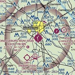
| Sectional chart |
|---|
|
| Airport distance calculator |
|---|
|
|
| Sunrise and sunset |
|---|
|
Times for 20-Jul-2026
| | Local
(UTC-4) | | Zulu
(UTC) |
|---|
| Morning civil twilight | | 06:01 | | 10:01 |
| Sunrise | | 06:29 | | 10:29 |
| Sunset | | 20:31 | | 00:31 |
| Evening civil twilight | | 20:59 | | 00:59 |
|
| Current date and time |
|---|
| Zulu (UTC) | 21-Jul-2026 03:30:33 |
|---|
| Local (UTC-4) | 20-Jul-2026 23:30:33 |
|---|
|
| METAR |
|---|
| KOGB | 210253Z AUTO 19005KT 10SM FEW039 SCT060 27/22 A2999 RMK AO2 SLP151 T02720217 53014
|
KXNO
14nm NW | 210255Z AUTO 16004KT 10SM CLR 28/21 A2995 RMK AO2 SLP141 T02830211 50010 $
|
|
| TAF |
|---|
| KOGB | 201720Z 2018/2118 VRB05KT P6SM SCT040 FM210600 20005KT P6SM SCT150 FM211200 22007KT P6SM SCT150
|
|
| NOTAMs |
|---|
NOTAMs are issued by the DoD/FAA and will open in a separate window not controlled by AirNav.
|
|

