FAA INFORMATION EFFECTIVE 16 APRIL 2026
Location
| FAA Identifier: | APC |
| Lat/Long: | 38-12-47.4810N 122-16-50.4740W
38-12.791350N 122-16.841233W
38.2131892,-122.2806872
(estimated) |
| Elevation: | 35.5 ft. / 10.8 m (surveyed) |
| Variation: | 15E (2005) |
| From city: | 5 miles S of NAPA, CA |
| Time zone: | UTC -7 (UTC -8 during Standard Time) |
| Zip code: | 94558 |
Airport Operations
| Airport use: | Open to the public |
| Activation date: | 10/1944 |
| Control tower: | yes |
| ARTCC: | OAKLAND CENTER |
| FSS: | OAKLAND FLIGHT SERVICE STATION |
| NOTAMs facility: | APC (NOTAM-D service available) |
| Attendance: | 0700-2000 |
| Wind indicator: | lighted |
| Segmented circle: | yes |
| Lights: | WHEN ATCT CLSD ACTVT MALS RWY 01L; REIL RWY 06; MIRL RWYS 01L/19R & RWY 06/24 - CTAF. PAPI RWY 19R OPR CONSLY. |
| Beacon: | white-green (lighted land airport)
Operates sunset to sunrise. |
| Landing fee: | yes, LDG FEE CHRGD TO ALL AIR TAXI, COML ACFT OPNS (EXCLDG FLT INSTRUCTION), AND TSNT ACFT WEIGHING MORE THAN 12500 LBS. |
Airport Communications
| CTAF: | 118.7 |
| UNICOM: | 122.95 |
| ATIS: | 124.05 |
| WX ASOS: | PHONE 707-252-7916 |
| NAPA GROUND: | 121.7 [0700-2000] |
| NAPA TOWER: | 118.7 257.8 [0700-2000] |
| CLEARANCE DELIVERY: | 127.85 |
| EMERG: | 121.5 |
| WX AWOS-3P at DVO (14 nm W): | 120.675 (415-897-2236) |
| WX AWOS-3P at O69 (16 nm W): | 132.325 (707-773-1529) |
| WX ASOS at CCR (17 nm SE): | PHONE 925-689-2077 |
| WX ASOS at VCB (18 nm NE): | 134.75 (707-240-8032) |
- APCH/DEP SVC PRVDD BY OAKLAND ARTCC (ZOA) ON FREQ 127.8/353.5 (MOUNT TAMALPAIS RCAG).
Nearby radio navigation aids
| VOR radial/distance | | VOR name | | Freq | | Var |
|---|
| SGDr048/4.8 | | SCAGGS ISLAND VORTAC | | 112.10 | | 17E |
| CCRr295/15.0 | | CONCORD VOR/DME | | 117.00 | | 17E |
| SAUr011/24.3 | | SAUSALITO VOR/DME | | 116.20 | | 17E |
| PYEr057/28.8 | | POINT REYES VOR/DME | | 113.70 | | 17E |
| OAKr338/29.4 | | OAKLAND VOR/DME | | 116.80 | | 17E |
| SFOr350/35.9 | | SAN FRANCISCO VOR/DME | | 115.80 | | 17E |
| SACr231/37.0 | | SACRAMENTO VORTAC | | 115.20 | | 17E |
Airport Services
| Fuel available: | 100LL JET-A
100LL:FOR FUEL SVC 2100-0600 CALL 707-224-0887. |
| Parking: | tiedowns |
| Airframe service: | MAJOR |
| Powerplant service: | MAJOR |
| Bottled oxygen: | HIGH/LOW |
| Bulk oxygen: | NONE |
Runway Information
Runway 1L/19R
| Dimensions: | 5930 x 150 ft. / 1807 x 46 m |
| Surface: | asphalt/grooved, in good condition |
| Weight bearing capacity: | | PCN 41 /F/D/X/T | | Single wheel: | 102.0 | | Double wheel: | 134.0 | | Double tandem: | 120.0 |
|
| Runway edge lights: | medium intensity |
| RUNWAY 1L | | RUNWAY 19R |
| Latitude: | 38-12.478625N | | 38-13.392320N |
| Longitude: | 122-17.116323W | | 122-16.677778W |
| Elevation: | 14.5 ft. | | 29.7 ft. |
| Traffic pattern: | left | | right |
| Runway heading: | 006 magnetic, 021 true | | 186 magnetic, 201 true |
| Markings: | precision, in good condition | | nonprecision, in good condition |
| Visual slope indicator: | | | 4-light PAPI on left (3.25 degrees glide path) |
| Approach lights: | MALS: 1,400 foot medium intensity approach lighting system | | |
| Runway end identifier lights: | no | | no |
| Touchdown point: | yes, no lights | | yes, no lights |
| Instrument approach: | ILS/DME | | |
Runway 6/24
| Dimensions: | 5008 x 150 ft. / 1526 x 46 m |
| Surface: | concrete, in good condition |
| Weight bearing capacity: | | PCN 21 /R/C/W/T | | Single wheel: | 60.0 | | Double wheel: | 76.0 | | Double tandem: | 120.0 |
|
| Runway edge lights: | medium intensity |
| RUNWAY 6 | | RUNWAY 24 |
| Latitude: | 38-12.462563N | | 38-12.651727N |
| Longitude: | 122-17.309152W | | 122-16.291387W |
| Elevation: | 14.5 ft. | | 35.5 ft. |
| Traffic pattern: | left | | left |
| Runway heading: | 062 magnetic, 077 true | | 242 magnetic, 257 true |
| Markings: | nonprecision, in good condition | | nonprecision, in good condition |
| Runway end identifier lights: | yes | | no |
| Touchdown point: | yes, no lights | | yes, no lights |
Runway 1R/19L
| Dimensions: | 2510 x 75 ft. / 765 x 23 m |
| Surface: | asphalt, in good condition |
| Weight bearing capacity: | | PCN 5 /F/D/X/T | | Single wheel: | 13.5 |
|
| RUNWAY 1R | | RUNWAY 19L |
| Latitude: | 38-12.724650N | | 38-13.111405N |
| Longitude: | 122-16.883820W | | 122-16.698170W |
| Elevation: | 12.5 ft. | | 21.4 ft. |
| Traffic pattern: | right | | left |
| Runway heading: | 006 magnetic, 021 true | | 186 magnetic, 201 true |
| Markings: | basic, in good condition | | basic, in good condition |
| Runway end identifier lights: | no | | no |
| Touchdown point: | yes, no lights | | yes, no lights |
Airport Ownership and Management from official FAA records
| Ownership: | Publicly-owned |
| Owner: | NAPA COUNTY
2000 AIRPORT RD.
NAPA, CA 94558
Phone 707-253-4300 |
| Manager: | MARK WITSOE
2000 AIRPORT RD.
NAPA, CA 94558
Phone 707-253-4300 |
Additional Remarks
| - | ASPH TWYS STRENGTH 30,000 GWT SINGLE WHEEL. |
| - | ASPH APRONS STRENGTH 12500-30000 LBS GWT SINGLE WHEEL. |
| - | UNLGTD BRIDGE 1 NM S, 167 FT AGL |
| - | DUE TO AIRPORT PROXIMITY TO WETLANDS BIRDS ON AND INVOF THE AIRPORT YEAR AROUND WITH HIGHEST CONCENTRATION OF ACTIVITY OF BIRDS ON THE RYS DURING RAINY WEATHER. |
| - | FOR CD WHEN ATCT CLSD CTC OAKLAND ARTCC AT 510-745-3380. |
Instrument Procedures
NOTE: All procedures below are presented as PDF files. If you need a reader for these files, you should download the free Adobe Reader.NOT FOR NAVIGATION. Please procure official charts for flight.
FAA instrument procedures published for use from 16 April 2026 at 0901Z to 14 May 2026 at 0900Z.
STARs - Standard Terminal Arrivals |
|---|
| REBAS ONE (RNAV) | |
2 pages:
[1] [2] (291KB) |
| VNYRD ONE (RNAV) | |
2 pages:
[1] [2] (290KB) |
IAPs - Instrument Approach Procedures |
|---|
| ILS OR LOC Z RWY 01L | |
download (330KB) |
| RNAV (GPS) RWY 06 | |
download (268KB) |
| RNAV (GPS) RWY 19R | |
download (298KB) |
| RNAV (GPS) Y RWY 01L | |
download (293KB) |
| RNAV (GPS) Z RWY 01L | |
download (313KB) |
| VOR RWY 06 | |
download (279KB) |
| NOTE: Special Alternate Minimums apply | |
download (139KB) |
Departure Procedures |
|---|
| LIZRD FIVE | |
download (247KB) |
| MERLOT THREE | |
2 pages:
[1] [2] (314KB) |
| OZIEE FOUR (RNAV) | |
2 pages:
[1] [2] (395KB) |
|
|---|
| NAPAA FOUR (OBSTACLE) | |
2 pages:
[1] [2] (751KB) |
| NAPAA FOUR (OBSTACLE), CONT.2 | |
download (447KB) |
| NOTE: Special Take-Off Minimums/Departure Procedures apply | |
download (128KB) |
Other nearby airports with instrument procedures:
KDVO - Gnoss Field Airport (14 nm W)
O69 - Petaluma Municipal Airport (16 nm W)
CA35 - San Rafael Airport (16 nm SW)
KCCR - Buchanan Field Airport (17 nm SE)
KSUU - Travis Air Force Base (17 nm E)
KVCB - Nut Tree Airport (18 nm NE)
|
|

Road maps at:
MapQuest
Bing
Google
| Aerial photo |
|---|
WARNING: Photo may not be current or correct
 Photo by Srinath Nandakumar
Photo taken 08-Jul-2020
looking east.
Photo by Srinath Nandakumar
Photo taken 08-Jul-2020
looking east.
Do you have a better or more recent aerial photo of Napa County Airport that you would like to share? If so, please send us your photo.
|
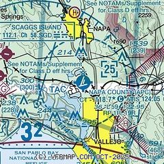
| Sectional chart |
|---|
|
CAUTION: Diagram may not be current
 Download PDF
of official airport diagram from the FAA
| Airport distance calculator |
|---|
|
|
| Sunrise and sunset |
|---|
|
Times for 27-Apr-2026
| | Local
(UTC-7) | | Zulu
(UTC) |
|---|
| Morning civil twilight | | 05:50 | | 12:50 |
| Sunrise | | 06:18 | | 13:18 |
| Sunset | | 19:55 | | 02:55 |
| Evening civil twilight | | 20:23 | | 03:23 |
|
| Current date and time |
|---|
| Zulu (UTC) | 27-Apr-2026 20:24:24 |
|---|
| Local (UTC-7) | 27-Apr-2026 13:24:24 |
|---|
|
| METAR |
|---|
| KAPC | 271954Z VRB06KT 10SM BKN055 17/08 A3004 RMK AO2 SLP163 T01670083
|
KDVO
14nm W | 271955Z AUTO VRB03KT 10SM BKN044 18/09 A3003 RMK AO2
|
KO69
16nm W | 271955Z AUTO 25006KT 10SM FEW039 OVC060 17/07 A3005 RMK A01
|
KCCR
17nm SE | 271953Z 26007KT 10SM SCT044 17/06 A3003 RMK AO2 SLP156 T01720061
|
KSUU
17nm E | 271955Z AUTO 29006KT 10SM FEW070 FEW095 SCT110 SCT160 19/09 A3002 RMK AO2 SLP172 T01870092 $
|
KVCB
19nm NE | 271953Z AUTO 25007KT 10SM OVC060 16/10 A3005 RMK AO2 SLP175 T01560100
|
|
| TAF |
|---|
| KAPC | 271720Z 2718/2818 22008KT P6SM SCT080 FM281200 VRB03KT P6SM BKN020
|
KSUU
17nm E | 271100Z 2711/2817 23009KT 9999 SCT050 BKN060 620603 QNH2994INS TEMPO 2712/2715 9000 BR BECMG 2718/2719 VRB06KT 9999 SCT060 QNH2996INS BECMG 2723/2724 23010KT 9999 SCT100 QNH2996INS BECMG 2807/2808 23009KT 8000 BR SKC QNH3004INS BECMG 2814/2815 VRB06KT 9999 NSW SKC QNH3006INS TX20/2723Z TN08/2713Z
|
|
| NOTAMs |
|---|
NOTAMs are issued by the DoD/FAA and will open in a separate window not controlled by AirNav.
|
|


