FAA INFORMATION EFFECTIVE 17 APRIL 2025
Location
| FAA Identifier: | BPI |
| Lat/Long: | 42-34-56.0000N 110-06-31.9000W
42-34.933333N 110-06.531667W
42.5822222,-110.1088611
(estimated) |
| Elevation: | 6993.6 ft. / 2131.6 m (surveyed) |
| Variation: | 10E (2025) |
| From city: | 3 miles N of BIG PINEY, WY |
| Time zone: | UTC -6 (UTC -7 during Standard Time) |
| Zip code: | 83113 |
Airport Operations
| Airport use: | Open to the public |
| Activation date: | 07/1941 |
| Control tower: | no |
| ARTCC: | SALT LAKE CITY CENTER |
| FSS: | CASPER FLIGHT SERVICE STATION |
| NOTAMs facility: | BPI (NOTAM-D service available) |
| Attendance: | MON-FRI 0900-1600
FOR SVC AFT HRS CALL 307-276-4022. |
| Wind indicator: | lighted |
| Segmented circle: | yes |
| Lights: | ACTVT REIL RWYS 13 & 31; PAPI RWYS 13 & 31; MIRL RWY 13/31 - 122.7. |
| Beacon: | white-green (lighted land airport)
Operates sunset to sunrise. |
Airport Communications
| CTAF/UNICOM: | 122.8 |
| WX ASOS: | 135.225 (307-276-9917) |
| WX AWOS-3 at PNA (18 nm NE): | 118.325 (307-367-6425) |
- COMMUNICATIONS PRVDD BY CASPER RADIO 122.3 (BIG PINEY RCO).
- APCH/DEP CTL SVC PRVDD BY SALT LAKE ARTCC (ZLC) ON 128.35/239.25 (BIG PINEY RCAG).
Nearby radio navigation aids
| VOR radial/distance | | VOR name | | Freq | | Var |
|---|
| BPI at field | | BIG PINEY VOR/DME | | 116.50 | | 10E |
Airport Services
| Fuel available: | 100LL JET-A
A:FUEL 24 HR CREDIT CARD SVC AVBL. JET A TRUCK ALSO AVBL. |
| Parking: | hangars and tiedowns |
| Airframe service: | NONE |
| Powerplant service: | NONE |
| Bottled oxygen: | NONE |
| Bulk oxygen: | NONE |
Runway Information
Runway 13/31
| Dimensions: | 6803 x 75 ft. / 2074 x 23 m |
| Surface: | asphalt, in good condition |
| Weight bearing capacity: | | PCN 31 /F/A/X/T | | Single wheel: | 45.0 | | Double wheel: | 60.0 |
|
| Runway edge lights: | medium intensity |
| RUNWAY 13 | | RUNWAY 31 |
| Latitude: | 42-35.577327N | | 42-34.631052N |
| Longitude: | 110-07.074010W | | 110-06.264372W |
| Elevation: | 6993.6 ft. | | 6948.8 ft. |
| Traffic pattern: | left | | left |
| Runway heading: | 138 magnetic, 148 true | | 318 magnetic, 328 true |
| Markings: | nonprecision, in good condition | | nonprecision, in good condition |
| Visual slope indicator: | 2-light PAPI on left (3.00 degrees glide path) | | 2-light PAPI on left (3.00 degrees glide path) |
| Runway end identifier lights: | yes | | yes |
| Touchdown point: | yes, no lights | | yes, no lights |
Runway 8/26
| Dimensions: | 3301 x 60 ft. / 1006 x 18 m |
| Surface: | turf/dirt, in good condition |
| RUNWAY 8 | | RUNWAY 26 |
| Latitude: | 42-34.599070N | | 42-34.566280N |
| Longitude: | 110-06.617395W | | 110-05.883595W |
| Elevation: | 6943.4 ft. | | 6935.8 ft. |
| Traffic pattern: | left | | left |
| Runway heading: | 083 magnetic, 093 true | | 263 magnetic, 273 true |
| Markings: | none, in fair condition | | none, in fair condition |
| Touchdown point: | yes, no lights | | yes, no lights |
| Obstructions: | 17 ft. pole, 798 ft. from runway, 21 ft. right of centerline, 46:1 slope to clear | | none |
Airport Ownership and Management from official FAA records
| Ownership: | Publicly-owned |
| Owner: | BIG PINEY-MARBLETON AIRPORT BOARD
P.O. BOX 307
BIG PINEY, WY 83113
Phone (307) 276-4022
ARPT BOARD CLERK - SHELLY BRAUSE (307) 749-2725. |
| Manager: | PHIL STEVENS
P.O. BOX 307
BIG PINEY, WY 83113
Phone 307-231-6244 |
Additional Remarks
| - | RY 08/26 NO LINE OF SIGHT. |
| - | FOR CD IF UNA TO CTC ON FSS FREQ, CTC SALT LAKE ARTCC AT 801-320-2568. |
Instrument Procedures
NOTE: All procedures below are presented as PDF files. If you need a reader for these files, you should download the free Adobe Reader.NOT FOR NAVIGATION. Please procure official charts for flight.
FAA instrument procedures published for use from 17 April 2025 at 0901Z to 15 May 2025 at 0900z.
IAPs - Instrument Approach Procedures |
|---|
| RNAV (GPS) RWY 31 | |
download (177KB) |
| VOR RWY 31 | |
download (152KB) |
| NOTE: Special Alternate Minimums apply | |
download (210KB) |
| NOTE: Special Take-Off Minimums/Departure Procedures apply | |
download (566KB) |
Other nearby airports with instrument procedures:
KPNA - Ralph Wenz Field Airport (18 nm NE)
KAFO - Afton Lincoln County Airport/General Boyd L Eddins Field (38 nm W)
KEMM - Kemmerer Municipal Airport (50 nm SW)
1U7 - Bear Lake County Airport (58 nm W)
KDUB - Dubois Municipal Airport (61 nm N)
|
|

Road maps at:
MapQuest
Bing
Google
| Aerial photo |
|---|
WARNING: Photo may not be current or correct
 Photo taken 29-Sep-2009
looking northwest.
Photo taken 29-Sep-2009
looking northwest.
Do you have a better or more recent aerial photo of Miley Memorial Field Airport that you would like to share? If so, please send us your photo.
|
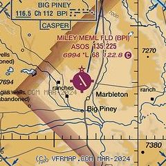
| Sectional chart |
|---|
|
CAUTION: Diagram may not be current

| Airport distance calculator |
|---|
|
|
| Sunrise and sunset |
|---|
|
Times for 25-Apr-2025
| | Local
(UTC-6) | | Zulu
(UTC) |
|---|
| Morning civil twilight | | 05:54 | | 11:54 |
| Sunrise | | 06:25 | | 12:25 |
| Sunset | | 20:12 | | 02:12 |
| Evening civil twilight | | 20:43 | | 02:43 |
|
| Current date and time |
|---|
| Zulu (UTC) | 26-Apr-2025 03:44:29 |
|---|
| Local (UTC-6) | 25-Apr-2025 21:44:29 |
|---|
|
| METAR |
|---|
| KBPI | 260253Z AUTO 04005KT 10SM SCT100 BKN120 04/03 A2998 RMK AO2 RAE17 SLP126 P0002 60014 T00440028 50009
|
KPNA
18nm NE | 260335Z AUTO 03006KT 10SM SCT060 SCT100 BKN120 03/02 A2999 RMK AO2
|
|
| TAF |
|---|
| KBPI | 260041Z 2601/2624 16010KT 6SM -SHRA SCT040 OVC080 TEMPO 2601/2603 3SM -TSRA OVC030CB FM260500 03006KT P6SM SCT050 OVC100 FM261300 VRB04KT P6SM BKN250 FM261900 20012G18KT P6SM SCT250
|
KPNA
18nm NE | 251949Z 2520/2618 19008KT P6SM SCT025 OVC040 FM260200 16008KT 6SM -SHRA SCT040 OVC080 FM260500 31006KT P6SM SCT050 OVC100 FM261300 VRB04KT P6SM BKN250
|
|
| NOTAMs |
|---|
NOTAMs are issued by the DoD/FAA and will open in a separate window not controlled by AirNav.
|
|


