FAA INFORMATION EFFECTIVE 19 FEBRUARY 2026
Location
| FAA Identifier: | C75 |
| Lat/Long: | 41-01-07.8000N 089-23-08.8000W
41-01.130000N 089-23.146667W
41.0188333,-89.3857778
(estimated) |
| Elevation: | 584.5 ft. / 178.2 m (surveyed) |
| Variation: | 01W (2000) |
| From city: | 1 mile E of LACON, IL |
| Time zone: | UTC -6 (UTC -5 during Daylight Saving Time) |
| Zip code: | 61540 |
Airport Operations
| Airport use: | Open to the public |
| Activation date: | 05/1951 |
| Control tower: | no |
| ARTCC: | CHICAGO CENTER |
| FSS: | KANKAKEE FLIGHT SERVICE STATION |
| NOTAMs facility: | C75 (NOTAM-D service available) |
| Attendance: | 0800-1700 |
| Wind indicator: | lighted |
| Segmented circle: | yes |
| Lights: | ACTVT MIRL RY 13/31; REIL RY 13 & PAPI RY 31 - CTAF. |
| Beacon: | white-green (lighted land airport)
Operates sunset to sunrise. |
Airport Communications
| CTAF/UNICOM: | 122.8 |
| WX AWOS-3: | 119.425 (309-246-3089) |
- APCH/DEP SVC PRVDD BY CHICAGO ARTCC (ZAU) ON FREQS 124.55/307.125 (BRADFORD RCAG).
Nearby radio navigation aids
| VOR radial/distance | | VOR name | | Freq | | Var |
|---|
| PIAr038/27.5 | | PEORIA VORTAC | | 115.20 | | 04E |
Airport Services
| Fuel available: | 100LL UL94
100LL:100LL & UL94 AVBL 24HR SELF SVC VIA CREDIT CARD. |
| Parking: | hangars and tiedowns |
| Airframe service: | MAJOR |
| Powerplant service: | MAJOR |
| Bottled oxygen: | NONE |
| Bulk oxygen: | NONE |
Runway Information
Runway 13/31
| Dimensions: | 4003 x 75 ft. / 1220 x 23 m |
| Surface: | asphalt, in good condition |
| Runway edge lights: | medium intensity |
| RUNWAY 13 | | RUNWAY 31 |
| Latitude: | 41-01.307960N | | 41-00.900833N |
| Longitude: | 089-23.494947W | | 089-22.810602W |
| Elevation: | 538.5 ft. | | 584.5 ft. |
| Traffic pattern: | left | | right |
| Runway heading: | 129 magnetic, 128 true | | 309 magnetic, 308 true |
| Markings: | nonprecision, in fair condition | | nonprecision, in fair condition |
| Visual slope indicator: | | | 4-light PAPI on left (4.00 degrees glide path) |
| Runway end identifier lights: | yes | | |
| Touchdown point: | yes, no lights | | yes, no lights |
| Obstructions: | none | | 56 ft. gnd, 1336 ft. from runway, 20:1 slope to clear |
Runway 18/36
| Dimensions: | 2199 x 50 ft. / 670 x 15 m |
| Surface: | asphalt, in good condition |
| Weight bearing capacity: | |
| Runway edge lights: | low intensity |
| RUNWAY 18 | | RUNWAY 36 |
| Latitude: | 41-01.355300N | | 41-00.993317N |
| Longitude: | 089-23.127760W | | 089-23.139020W |
| Elevation: | 554.2 ft. | | 547.7 ft. |
| Traffic pattern: | left | | left |
| Runway heading: | 182 magnetic, 181 true | | 002 magnetic, 001 true |
| Markings: | basic, in good condition | | basic, in good condition |
| Touchdown point: | yes, no lights | | yes, no lights |
| Obstructions: | 9 ft. road, 334 ft. from runway, 14:1 slope to clear | | none |
Airport Ownership and Management from official FAA records
| Ownership: | Publicly-owned |
| Owner: | MARSHALL COUNTY
122 N PRAIRIE ST
LACON, IL 61540
Phone 309-246-3667 |
| Manager: | JOE TROGLIO
1315 IL-17, PO BOX 38
LACON, IL 61540
Phone 309-246-2870
CELL PHONE: 309-863-5216 |
Additional Remarks
| - | RY 31 DEPARTURES ENCOURAGED TO BEGIN RIGHT TURN AS SOON AS PRACTICAL FOR NOISE ABATEMENT |
| - | FOR CD CTC CHICAGO ARTCC AT 630-906-8921. |
| - | BIRDS AND ANIMALS ON AND INVOF ARPT. |
| - | RWY 31 R TFC & RWY 13 L TFC DUE TO NOISE ABATEMENT. |
Instrument Procedures
NOTE: All procedures below are presented as PDF files. If you need a reader for these files, you should download the free Adobe Reader.NOT FOR NAVIGATION. Please procure official charts for flight.
FAA instrument procedures published for use from 19 February 2026 at 0901Z to 19 March 2026 at 0900Z.
IAPs - Instrument Approach Procedures |
|---|
| RNAV (GPS) RWY 13 | |
download (244KB) |
| NOTE: Special Alternate Minimums apply | |
download (161KB) |
| NOTE: Special Take-Off Minimums/Departure Procedures apply | |
download (504KB) |
Other nearby airports with instrument procedures:
3MY - Mount Hawley Auxiliary Airport (17 nm SW)
KVYS - Illinois Valley Regional Airport-Walter A Duncan Field (22 nm NE)
KPIA - General Downing - Peoria International Airport (25 nm SW)
KEZI - Kewanee Municipal Airport (28 nm NW)
C15 - Pekin Municipal Airport (34 nm SW)
|
|

Road maps at:
MapQuest
Bing
Google
| Aerial photo |
|---|
WARNING: Photo may not be current or correct
 Photo by Caleb Scott
Photo taken 24-Nov-2013
looking northwest.
Photo by Caleb Scott
Photo taken 24-Nov-2013
looking northwest.
Do you have a better or more recent aerial photo of Marshall County Airport that you would like to share? If so, please send us your photo.
|
| Sectional chart |
|---|
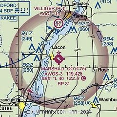
|
| Airport distance calculator |
|---|
|
|
| Sunrise and sunset |
|---|
|
Times for 09-Mar-2026
| | Local
(UTC-6) | | Zulu
(UTC) |
|---|
| Morning civil twilight | | 05:53 | | 11:53 |
| Sunrise | | 06:20 | | 12:20 |
| Sunset | | 17:56 | | 23:56 |
| Evening civil twilight | | 18:24 | | 00:24 |
|
| Current date and time |
|---|
| Zulu (UTC) | 09-Mar-2026 14:59:17 |
|---|
| Local (UTC-6) | 09-Mar-2026 08:59:17 |
|---|
|
| METAR |
|---|
| KC75 | 091435Z AUTO 23013G18KT 10SM CLR 13/02 A2977 RMK AO2 T01300023
|
|
| TAF |
|---|
KPIA
25nm SW | 091120Z 0912/1012 20010KT P6SM SKC WS020/24045KT FM091600 20014G22KT P6SM FEW035 FM100000 20011KT P6SM SCT025 BKN040
|
|
| NOTAMs |
|---|
NOTAMs are issued by the DoD/FAA and will open in a separate window not controlled by AirNav.
|
|

