FAA INFORMATION EFFECTIVE 25 DECEMBER 2025
Location
| FAA Identifier: | PIA |
| Lat/Long: | 40-39-51.1000N 089-41-35.7000W
40-39.851667N 089-41.595000W
40.6641944,-89.6932500
(estimated) |
| Elevation: | 660.7 ft. / 201.4 m (surveyed) |
| Variation: | 02W (2015) |
| From city: | 4 miles W of PEORIA, IL |
| Time zone: | UTC -6 (UTC -5 during Daylight Saving Time) |
| Zip code: | 61607 |
Airport Operations
| Airport use: | Open to the public |
| Activation date: | 04/1940 |
| Control tower: | yes |
| ARTCC: | KANSAS CITY CENTER |
| FSS: | KANKAKEE FLIGHT SERVICE STATION |
| NOTAMs facility: | PIA (NOTAM-D service available) |
| Attendance: | CONTINUOUS |
| Wind indicator: | lighted |
| Segmented circle: | no |
| Beacon: | white-green (lighted land airport)
Operates sunset to sunrise. |
| Fire and rescue: | ARFF index B |
| International operations: | customs landing rights airport |
Airport Communications
| UNICOM: | 122.95 |
| ATIS: | 126.1 282.2 |
| WX ASOS: | PHONE 309-322-3740 |
| PEORIA GROUND: | 121.85 348.6 |
| PEORIA TOWER: | 124.0 353.85 |
| SAINT LOUIS APPROACH: | 125.8 |
| SAINT LOUIS DEPARTURE: | 125.8 |
| CLEARANCE DELIVERY: | 124.675 317.55 |
| ANG OPS: | 141.35 282.825 |
| ARNG OPS: | 141.15 280.9 38.925 |
| CLASS C: | 125.8 |
| EMERG: | 121.5 243.0 |
Nearby radio navigation aids
| VOR radial/distance | | VOR name | | Freq | | Var |
|---|
| PIAr098/4.6 | | PEORIA VORTAC | | 115.20 | | 04E |
| NDB name | | Hdg/Dist | | Freq | | Var | | ID |
|---|
| TUNGG | | 310/5.8 | | 356 | | 02W | | PI | .--. .. |
| ABRAHAM | | 332/34.3 | | 329 | | 00E | | AAA | .- .- .- |
Airport Services
| Fuel available: | 100LL JET-A JET-A++ |
| Parking: | hangars and tiedowns |
| Airframe service: | MAJOR |
| Powerplant service: | MAJOR |
| Bottled oxygen: | NONE |
| Bulk oxygen: | HIGH/LOW |
Runway Information
Runway 13/31
| Dimensions: | 10104 x 150 ft. / 3080 x 46 m |
| Surface: | concrete/grooved, in good condition |
| Weight bearing capacity: | | Single wheel: | 100.0 | | Double wheel: | 175.0 | | Double tandem: | 310.0 |
|
| Runway edge lights: | high intensity |
| RUNWAY 13 | | RUNWAY 31 |
| Latitude: | 40-40.422338N | | 40-39.432373N |
| Longitude: | 089-42.832218W | | 089-41.075852W |
| Elevation: | 635.7 ft. | | 642.2 ft. |
| Traffic pattern: | left | | left |
| Runway heading: | 129 magnetic, 127 true | | 309 magnetic, 307 true |
| Displaced threshold: | 500 ft. | | no |
| Declared distances: | TORA:10104 TODA:10104 ASDA:9604 LDA:9604 | | TORA:10104 TODA:10104 ASDA:10104 LDA:10104 |
| Markings: | precision, in good condition | | precision, in good condition |
| Visual slope indicator: | 4-light PAPI on right (3.00 degrees glide path) | | |
| RVR equipment: | touchdown, rollout | | touchdown, rollout |
| Approach lights: | MALSR: 1,400 foot medium intensity approach lighting system with runway alignment indicator lights | | MALSR: 1,400 foot medium intensity approach lighting system with runway alignment indicator lights |
| Runway end identifier lights: | no | | no |
| Touchdown point: | yes, no lights | | yes, no lights |
| Instrument approach: | ILS | | ILS |
| Obstructions: | 137 ft. tree, 5034 ft. from runway, 254 ft. left of centerline, 35:1 slope to clear
APCH SLOPE 36:1 TO DSPLCD THLD. | | 79 ft. tree, 3695 ft. from runway, 458 ft. right of centerline, 44:1 slope to clear |
Runway 4/22
| Dimensions: | 8004 x 150 ft. / 2440 x 46 m |
| Surface: | asphalt/grooved, in fair condition |
| Weight bearing capacity: | | Single wheel: | 100.0 | | Double wheel: | 175.0 | | Double tandem: | 300.0 |
|
| Runway edge lights: | high intensity |
| RUNWAY 4 | | RUNWAY 22 |
| Latitude: | 40-39.242072N | | 40-40.271672N |
| Longitude: | 089-41.683203W | | 089-40.602430W |
| Elevation: | 642.5 ft. | | 656.7 ft. |
| Traffic pattern: | left | | left |
| Runway heading: | 041 magnetic, 039 true | | 221 magnetic, 219 true |
| Declared distances: | TORA:8004 TODA:8004 ASDA:7826 LDA:7826 | | TORA:8004 TODA:8004 ASDA:8004 LDA:8004 |
| Markings: | precision, in fair condition | | precision, in fair condition |
| Visual slope indicator: | 4-light PAPI on right (3.00 degrees glide path) | | 4-light PAPI on left (3.00 degrees glide path)
RWY 22 PAPI UNUSBL BYD 9 DEGS RIGHT OF CNTRLN. |
| RVR equipment: | touchdown, rollout | | touchdown, rollout |
| Approach lights: | MALSR: 1,400 foot medium intensity approach lighting system with runway alignment indicator lights | | |
| Runway end identifier lights: | no | | no |
| Touchdown point: | yes, no lights | | yes, no lights |
| Instrument approach: | ILS/DME | | |
| Obstructions: | 47 ft. tree, 1013 ft. from runway, 291 ft. right of centerline, 17:1 slope to clear | | 93 ft. tree, 2500 ft. from runway, 50 ft. both sides of centerline, 24:1 slope to clear |
Airport Ownership and Management from official FAA records
| Ownership: | Publicly-owned |
| Owner: | METROPOLITAN ARPT AUTH OF PEORIA
6100 WEST E.M. DIRKSEN PKWY
PEORIA, IL 61607
Phone 309-697-8272 |
| Manager: | GENE OLSON
6100 WEST E.M. DIRKSEN PKWY
PEORIA, IL 61607
Phone 309-697-8272
AIRPORT OPERATIONS 309-697-8272 X 110 |
Additional Remarks
| A39-13/31 | PCR VALUE: 760/F/C/X/T |
| A39-04/22 | PCR VALUE: 800/F/C/X/T |
| - | LGTD PLINE RWY 04 APCH. |
| - | BIRDS ON AND INVOF ARPT. |
| - | PORTION OF TWY A-5 NOT VISIBLE FROM TWR DUE TO A BLDG. |
| - | ANG: MILITARY AIRCRAFT CALL 'TORCH OPS' 20 MIN PRIOR TO LDG. |
Instrument Procedures
NOTE: All procedures below are presented as PDF files. If you need a reader for these files, you should download the free Adobe Reader.NOT FOR NAVIGATION. Please procure official charts for flight.
FAA instrument procedures published for use from 25 December 2025 at 0901z to 22 January 2026 at 0900z.
IAPs - Instrument Approach Procedures |
|---|
| ILS OR LOC RWY 04 | |
download (281KB) |
| ILS OR LOC RWY 13 | |
download (269KB) |
| ILS OR LOC RWY 31 | |
download (311KB) |
| ILS RWY 04 (SA CAT I - II) | |
download (261KB) |
| RNAV (GPS) RWY 04 | |
download (288KB) |
| RNAV (GPS) RWY 13 | |
download (297KB) |
| RNAV (GPS) RWY 22 | |
download (259KB) |
| RNAV (GPS) RWY 31 | |
download (299KB) |
| HI-VOR Y OR TACAN Y RWY 31 | |
download (150KB) |
| VOR OR TACAN RWY 13 | |
download (223KB) |
| VOR Z OR TACAN Z RWY 31 | |
download (247KB) |
| VOR Z OR TACAN Z RWY 31 | |
download (247KB) |
| NDB RWY 31 | |
download (225KB) |
| NOTE: Special Alternate Minimums apply | |
download (161KB) |
| NOTE: Special Take-Off Minimums/Departure Procedures apply | |
download |
Other nearby airports with instrument procedures:
3MY - Mount Hawley Auxiliary Airport (9 nm NE)
C15 - Pekin Municipal Airport (11 nm S)
KCTK - Ingersoll Airport (18 nm W)
C75 - Marshall County Airport (25 nm NE)
KAAA - Logan County Airport (34 nm SE)
|
|

Road maps at:
MapQuest
Bing
Google
| Aerial photo |
|---|
WARNING: Photo may not be current or correct
 Photo by W.E. McCowan
Photo taken 05-May-2019
looking west.
Photo by W.E. McCowan
Photo taken 05-May-2019
looking west.
Do you have a better or more recent aerial photo of General Downing - Peoria International Airport that you would like to share? If so, please send us your photo.
|
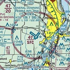
| Sectional chart |
|---|
|
 Download PDF
of official airport diagram from the FAA
| Airport distance calculator |
|---|
|
|
| Sunrise and sunset |
|---|
|
Times for 27-Dec-2025
| | Local
(UTC-6) | | Zulu
(UTC) |
|---|
| Morning civil twilight | | 06:52 | | 12:52 |
| Sunrise | | 07:23 | | 13:23 |
| Sunset | | 16:37 | | 22:37 |
| Evening civil twilight | | 17:08 | | 23:08 |
|
| Current date and time |
|---|
| Zulu (UTC) | 27-Dec-2025 21:53:10 |
|---|
| Local (UTC-6) | 27-Dec-2025 15:53:10 |
|---|
|
| METAR |
|---|
| KPIA | 272101Z 14010G16KT 9SM OVC006 08/07 A2985 RMK AO2 T00780067 $
|
|
| TAF |
|---|
| KPIA | 271844Z 2719/2818 12010KT 2SM BR OVC002 FM272000 14010KT 3SM BR OVC006 FM272100 15009G18KT P6SM OVC008 FM280000 14012G20KT 3SM BR OVC006 FM280200 16010G18KT 1SM BR OVC005 PROB30 2806/2812 3SM -SHRA OVC004 FM281300 18006KT 1 1/2SM -SHRA OVC005 FM281500 20008KT 3SM -SHRA OVC008
|
|
| NOTAMs |
|---|
NOTAMs are issued by the DoD/FAA and will open in a separate window not controlled by AirNav.
|
|


