FAA INFORMATION EFFECTIVE 14 MAY 2026
Location
| FAA Identifier: | EZI |
| Lat/Long: | 41-12-18.7000N 089-57-49.9000W
41-12.311667N 089-57.831667W
41.2051944,-89.9638611
(estimated) |
| Elevation: | 858 ft. / 261.5 m (surveyed) |
| Variation: | 02W (2015) |
| From city: | 3 miles SW of KEWANEE, IL |
| Time zone: | UTC -5 (UTC -6 during Standard Time) |
| Zip code: | 61443 |
Airport Operations
| Airport use: | Open to the public |
| Control tower: | no |
| ARTCC: | CHICAGO CENTER |
| FSS: | KANKAKEE FLIGHT SERVICE STATION |
| NOTAMs facility: | IKK (NOTAM-D service available) |
| Attendance: | MON-FRI 0800-1800, ALL SAT 0900-1700, ALL SUN 0900-1700 |
| Pattern altitude: | 1258 ft. MSL
TPA: 400 FT AGL ULTRALIGHT. |
| Wind indicator: | lighted |
| Segmented circle: | yes |
| Lights: | MIRL RY 09/27 PRESET ON LOW INTST; TO INCR INTST & ACTVT MIRL RY 01/19 & TWY LGTS - CTAF. |
| Beacon: | white-green (lighted land airport)
Operates sunset to sunrise. |
Airport Communications
| CTAF/UNICOM: | 122.8 |
| QUAD CITY APPROACH: | 133.275 |
| QUAD CITY DEPARTURE: | 133.275 |
- APCH/DEP SVC PRVDD BY CHICAGO ARTCC (ZAU) ON FREQS 118.75/377.05 (MOLINE RCAG) WHEN QUAD CITY APCH CLSD.
Nearby radio navigation aids
| VOR radial/distance | | VOR name | | Freq | | Var |
|---|
| MZVr098/31.2 | | MOLINE VOR/DME | | 114.40 | | 05E |
| PIAr342/32.4 | | PEORIA VORTAC | | 115.20 | | 04E |
| CVAr138/38.2 | | DAVENPORT VORTAC | | 113.80 | | 04E |
Airport Services
| Fuel available: | 100LL
100LL:24 HR FUEL AVBL WITH CREDIT CARD. |
| Parking: | hangars and tiedowns |
| Airframe service: | MAJOR |
| Powerplant service: | MAJOR |
| Bottled oxygen: | NONE |
| Bulk oxygen: | NONE |
Runway Information
Runway 9/27
| Dimensions: | 4500 x 75 ft. / 1372 x 23 m |
| Surface: | asphalt, in good condition |
| Weight bearing capacity: | |
| Runway edge lights: | medium intensity |
| RUNWAY 9 | | RUNWAY 27 |
| Latitude: | 41-12.245988N | | 41-12.231790N |
| Longitude: | 089-58.428632W | | 089-57.447698W |
| Elevation: | 853.8 ft. | | 856.3 ft. |
| Traffic pattern: | left | | left |
| Runway heading: | 093 magnetic, 091 true | | 273 magnetic, 271 true |
| Markings: | nonprecision, in good condition | | nonprecision, in good condition |
| Visual slope indicator: | pulsating/steady burning VASI on left (3.50 degrees glide path)
RY 09 PVASI UNUSBL BYD 6 DEG LEFT AND RIGHT OF CNTRLN. | | pulsating/steady burning VASI on left (3.00 degrees glide path)
RY 27 PVASI UNUSBL BYD 6 DEG LEFT AND RIGHT OF CNTRLN. |
| Runway end identifier lights: | | | no |
| Touchdown point: | yes, no lights | | yes, no lights |
Runway 1/19
| Dimensions: | 3200 x 60 ft. / 975 x 18 m |
| Surface: | asphalt, in good condition |
| Weight bearing capacity: | |
| Runway edge lights: | medium intensity |
| RUNWAY 1 | | RUNWAY 19 |
| Latitude: | 41-12.156590N | | 41-12.673108N |
| Longitude: | 089-57.752145W | | 089-57.614733W |
| Elevation: | 855.1 ft. | | 837.6 ft. |
| Traffic pattern: | left | | left |
| Runway heading: | 013 magnetic, 011 true | | 193 magnetic, 191 true |
| Markings: | nonprecision, in good condition | | nonprecision, in good condition |
| Touchdown point: | yes, no lights | | yes, no lights |
Airport Ownership and Management from official FAA records
| Ownership: | Publicly-owned |
| Owner: | KEWANEE AIRPORT AUTHORITY
3769 MIDLAND RD
KEWANEE, IL 61443
Phone 309-853-8671 |
| Manager: | ROSS CARBIENER
3769 MIDLAND RD.
KEWANEE, IL 61443
Phone 309-853-8671 |
Additional Remarks
| - | ULTRALIGHT ACTIVITY ON & INVOF ARPT. |
| - | HOSPITAL HELIPORT 1.2 NM NORTHEAST OF ARPT. |
| - | FOR CD CTC CHICAGO ARTCC AT 630-906-8921. |
| - | AUTOMATED WX ADZY AVBL ON CTAF - 4 MIC CLICKS TO ACTVT. 5 CLICKS IS ABBREIATED "WIND ONLY" |
Instrument Procedures
NOTE: All procedures below are presented as PDF files. If you need a reader for these files, you should download the free Adobe Reader.NOT FOR NAVIGATION. Please procure official charts for flight.
FAA instrument procedures published for use from 14 May 2026 at 0901Z to 11 June 2026 at 0900z.
IAPs - Instrument Approach Procedures |
|---|
| RNAV (GPS) RWY 01 **CHANGED** | |
download (203KB) |
| RNAV (GPS) RWY 09 **CHANGED** | |
download (237KB) |
| RNAV (GPS) RWY 19 **CHANGED** | |
download (205KB) |
| RNAV (GPS) RWY 27 **CHANGED** | |
download (223KB) |
| NOTE: Special Take-Off Minimums/Departure Procedures apply | |
download (485KB) |
Other nearby airports with instrument procedures:
KGBG - Harrel W Timmons Galesburg Regional Airport (27 nm SW)
C75 - Marshall County Airport (28 nm SE)
KMLI - Quad Cities International Airport (29 nm NW)
3MY - Mount Hawley Auxiliary Airport (29 nm SE)
C66 - Monmouth Municipal Airport (34 nm SW)
|
|

Road maps at:
MapQuest
Bing
Google
| Aerial photo |
|---|
WARNING: Photo may not be current or correct
 Photo by Greg Neaveill
Photo taken 09-Nov-2016
looking southeast
Photo by Greg Neaveill
Photo taken 09-Nov-2016
looking southeast
Do you have a better or more recent aerial photo of Kewanee Municipal Airport that you would like to share? If so, please send us your photo.
|
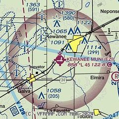
| Sectional chart |
|---|
|
| Airport distance calculator |
|---|
|
|
| Sunrise and sunset |
|---|
|
Times for 15-May-2026
| | Local
(UTC-5) | | Zulu
(UTC) |
|---|
| Morning civil twilight | | 05:11 | | 10:11 |
| Sunrise | | 05:42 | | 10:42 |
| Sunset | | 20:10 | | 01:10 |
| Evening civil twilight | | 20:41 | | 01:41 |
|
| Current date and time |
|---|
| Zulu (UTC) | 15-May-2026 11:52:03 |
|---|
| Local (UTC-5) | 15-May-2026 06:52:03 |
|---|
|
| METAR |
|---|
KGBG
27nm SW | 151135Z AUTO 16007KT 10SM OVC060 12/10 A2990 RMK AO2 T01170099
|
KC75
29nm SE | 151135Z AUTO 17012G16KT 10SM SCT031 BKN055 OVC065 12/08 A2993 RMK AO2 T01160083
|
KMLI
29nm NW | 151052Z 17009G17KT 10SM BKN060 OVC080 14/09 A2984 RMK AO2 SLP103 T01390089
|
KPIA
35nm S | 151054Z 17011KT 10SM OVC034 12/09 A2994 RMK AO2 RAE50 SLP136 P0006 T01170094
|
KSQI
35nm N | 151056Z AUTO 10SM FEW001 15/06 A2989 RMK AO2 SLP117 T01500061 $
|
KDVN
37nm NW | 151052Z AUTO 15013G22KT 10SM FEW085 14/09 A2984 RMK AO2 SLP098 T01390089
|
KVYS
38nm E | 151120Z AUTO 18017G23KT 10SM SCT044 BKN070 OVC080 14/07 A2993 RMK AO2
|
KCWI
40nm NW | 151056Z AUTO 18016G19KT 10SM OVC080 15/08 A2986 RMK AO2 SLP110 T01500083
|
|
| TAF |
|---|
KMLI
29nm NW | 150536Z 1506/1606 15012KT P6SM BKN100 PROB30 1508/1510 5SM -SHRA FM151300 18012G20KT P6SM SCT050
|
KPIA
35nm S | 150523Z 1506/1606 16009KT P6SM FEW050 SCT180 BKN250 FM151000 17010G18KT P6SM -SHRA BKN050 PROB30 1510/1512 4SM -TSRA OVC030CB FM151400 17013G22KT P6SM SCT040 BKN080 FM160000 16011KT P6SM FEW250
|
|
| NOTAMs |
|---|
NOTAMs are issued by the DoD/FAA and will open in a separate window not controlled by AirNav.
|
|

