FAA INFORMATION EFFECTIVE 14 MAY 2026
Location
| FAA Identifier: | GBG |
| Lat/Long: | 40-56-16.8019N 090-25-52.0449W
40-56.280032N 090-25.867415W
40.9380005,-90.4311236
(estimated) |
| Elevation: | 764.3 ft. / 233.0 m (surveyed) |
| Variation: | 02W (2025) |
| From city: | 3 miles SW of GALESBURG, IL |
| Time zone: | UTC -5 (UTC -6 during Standard Time) |
| Zip code: | 61401 |
Airport Operations
| Airport use: | Open to the public |
| Activation date: | 02/1957 |
| Control tower: | no |
| ARTCC: | CHICAGO CENTER |
| FSS: | KANKAKEE FLIGHT SERVICE STATION |
| NOTAMs facility: | GBG (NOTAM-D service available) |
| Attendance: | MON-FRI 0700-1900 |
| Wind indicator: | lighted |
| Segmented circle: | yes |
| Lights: | ACTVT MALSR RWY 03; REIL RWY 21; PAPI RWY 21; HIRL RWY 03/21; MIRL RWY 10/28 - CTAF. SS-SR HIRL RWY 03/21; MIRL RWY 10/28 PRESET LOW INTST; INCR INTST - CTAF. |
| Beacon: | white-green (lighted land airport)
Operates sunset to sunrise. |
Airport Communications
| CTAF/UNICOM: | 123.0 |
| WX AWOS-3: | 118.975 (309-343-3711) |
| QUAD CITY APPROACH: | 133.275 |
| QUAD CITY DEPARTURE: | 133.275 |
| CLEARANCE DELIVERY: | 120.7 |
- APCH/DEP SVC PRVDD BY CHICAGO ARTCC ON FREQS 135.6/316.1 (BURLINGTON RCAG) WHEN QUAD CITY APCH CTL CLSD.
Nearby radio navigation aids
| VOR radial/distance | | VOR name | | Freq | | Var |
|---|
| MZVr153/24.8 | | MOLINE VOR/DME | | 114.40 | | 05E |
| BRLr055/25.9 | | BURLINGTON VOR/DME | | 115.55 | | 05E |
| PIAr294/32.9 | | PEORIA VORTAC | | 115.20 | | 04E |
| NDB name | | Hdg/Dist | | Freq | | Var | | ID |
|---|
| MACOMB | | 012/25.9 | | 251 | | 01E | | JZY | .--- --.. -.-- |
Airport Services
| Fuel available: | 100LL JET-A
100LL:SELF SVC H24. |
| Parking: | hangars |
| Airframe service: | MAJOR |
| Powerplant service: | MAJOR |
| Bulk oxygen: | LOW |
Runway Information
Runway 3/21
| Dimensions: | 5792 x 150 ft. / 1765 x 46 m |
| Surface: | asphalt/porous friction courses, in good condition |
| Weight bearing capacity: | | Single wheel: | 47.0 | | Double wheel: | 57.0 | | Double tandem: | 85.0 |
|
| Runway edge lights: | high intensity |
| RUNWAY 3 | | RUNWAY 21 |
| Latitude: | 40-55.854077N | | 40-56.694858N |
| Longitude: | 090-26.189208W | | 090-25.595488W |
| Elevation: | 754.5 ft. | | 764.3 ft. |
| Traffic pattern: | left | | left |
| Runway heading: | 030 magnetic, 028 true | | 210 magnetic, 208 true |
| Markings: | precision, in good condition | | nonprecision, in good condition |
| Visual slope indicator: | | | 4-light PAPI on left (3.00 degrees glide path) |
| Approach lights: | MALSR: 1,400 foot medium intensity approach lighting system with runway alignment indicator lights | | |
| Runway end identifier lights: | | | yes |
| Touchdown point: | yes, no lights | | yes, no lights |
| Instrument approach: | ILS | | |
| Obstructions: | 18 ft. tree, 1007 ft. from runway, 182 ft. left of centerline, 44:1 slope to clear | | 57 ft. tree, 1731 ft. from runway, 623 ft. left of centerline, 26:1 slope to clear |
Runway 10/28
| Dimensions: | 3600 x 100 ft. / 1097 x 30 m |
| Surface: | asphalt, in good condition |
| Weight bearing capacity: | | Single wheel: | 30.0 | | Double wheel: | 40.0 |
|
| Runway edge lights: | medium intensity |
| RUNWAY 10 | | RUNWAY 28 |
| Latitude: | 40-56.345605N | | 40-56.232367N |
| Longitude: | 090-26.211003W | | 090-25.443597W |
| Elevation: | 757.5 ft. | | 757.5 ft. |
| Traffic pattern: | left | | left |
| Runway heading: | 103 magnetic, 101 true | | 283 magnetic, 281 true |
| Markings: | basic, in good condition | | basic, in good condition |
| Runway end identifier lights: | no | | no |
| Touchdown point: | yes, no lights | | yes, no lights |
| Obstructions: | none | | 2 ft. tree, 207 ft. from runway, 3:1 slope to clear |
Airport Ownership and Management from official FAA records
| Ownership: | Publicly-owned |
| Owner: | CITY OF GALESBURG
55 W. TOMPKINS ST
GALESBURG, IL 61401
Phone (309) 342-3134 |
| Manager: | AARON GAVIN
55 W. TOMPKINS ST
GALESBURG, IL 61401
Phone 309-345-3624 |
Instrument Procedures
NOTE: All procedures below are presented as PDF files. If you need a reader for these files, you should download the free Adobe Reader.NOT FOR NAVIGATION. Please procure official charts for flight.
FAA instrument procedures published for use from 14 May 2026 at 0901Z to 11 June 2026 at 0900Z.
IAPs - Instrument Approach Procedures |
|---|
| ILS OR LOC RWY 03 | |
download (264KB) |
| RNAV (GPS) RWY 03 | |
download (234KB) |
| RNAV (GPS) RWY 21 | |
download (204KB) |
| NOTE: Special Alternate Minimums apply | |
download (163KB) |
| NOTE: Special Take-Off Minimums/Departure Procedures apply | |
download (518KB) |
Other nearby airports with instrument procedures:
C66 - Monmouth Municipal Airport (9 nm W)
KEZI - Kewanee Municipal Airport (27 nm NE)
KMQB - Macomb Municipal Airport (27 nm S)
KCTK - Ingersoll Airport (27 nm SE)
KMLI - Quad Cities International Airport (31 nm N)
|
|

Road maps at:
MapQuest
Bing
Google
| Aerial photo |
|---|
WARNING: Photo may not be current or correct
 Photo taken 20-Jun-2009
looking northeast.
Photo taken 20-Jun-2009
looking northeast.
Do you have a better or more recent aerial photo of Harrel W Timmons Galesburg Regional Airport that you would like to share? If so, please send us your photo.
|
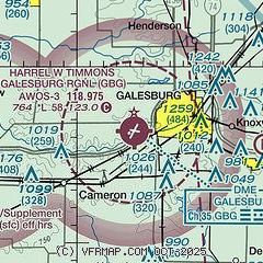
| Sectional chart |
|---|
|
CAUTION: Diagram may not be current

| Airport distance calculator |
|---|
|
|
| Sunrise and sunset |
|---|
|
Times for 20-May-2026
| | Local
(UTC-5) | | Zulu
(UTC) |
|---|
| Morning civil twilight | | 05:09 | | 10:09 |
| Sunrise | | 05:41 | | 10:41 |
| Sunset | | 20:16 | | 01:16 |
| Evening civil twilight | | 20:48 | | 01:48 |
|
| Current date and time |
|---|
| Zulu (UTC) | 20-May-2026 05:07:36 |
|---|
| Local (UTC-5) | 20-May-2026 00:07:36 |
|---|
|
| METAR |
|---|
| KGBG | 200455Z AUTO 33006KT 10SM OVC095 11/07 A3021 RMK AO2 T01120073
|
|
| TAF |
|---|
KMLI
31nm N | 192159Z 1922/2018 30012KT P6SM OVC025 FM200200 31012G18KT P6SM BKN035 FM200400 34010KT P6SM SCT020 BKN200 FM201400 03010KT P6SM SCT200
|
KBRL
33nm W | 192200Z 1922/2018 32010KT P6SM OVC025 FM200000 33010KT P6SM BKN030 FM200200 36010KT P6SM SCT020 BKN200 FM201400 02010KT P6SM SCT200
|
KPIA
38nm SE | 192212Z 1922/2018 30010G18KT P6SM BKN015 FM200000 34007KT P6SM SCT025 BKN050 FM201300 03008KT P6SM SCT100
|
|
| NOTAMs |
|---|
NOTAMs are issued by the DoD/FAA and will open in a separate window not controlled by AirNav.
|
|


