FAA INFORMATION EFFECTIVE 20 MARCH 2025
Location
| FAA Identifier: | COQ |
| Lat/Long: | 46-42-04.0000N 092-30-12.8000W
46-42.066667N 092-30.213333W
46.7011111,-92.5035556
(estimated) |
| Elevation: | 1279.1 ft. / 389.9 m (surveyed) |
| Variation: | 01W (2015) |
| From city: | 3 miles SW of CLOQUET, MN |
| Time zone: | UTC -5 (UTC -6 during Standard Time) |
| Zip code: | 55720 |
Airport Operations
| Airport use: | Open to the public |
| Activation date: | 04/1942 |
| Control tower: | no |
| ARTCC: | MINNEAPOLIS CENTER |
| FSS: | PRINCETON FLIGHT SERVICE STATION |
| NOTAMs facility: | COQ (NOTAM-D service available) |
| Attendance: | MON-SAT 0800-1700
FOR SVC AFT HRS CALL 218-393-2405. |
| Wind indicator: | lighted |
| Segmented circle: | no |
| Lights: | ACTVT ODALS RWY 36; REIL RWY 18 & 36; PAPI RWY 18 & 36; MIRL RWY 18/36 & 07/25 - CTAF. |
| Beacon: | white-green (lighted land airport)
Operates sunset to sunrise. |
Airport Communications
| CTAF/UNICOM: | 122.8 |
| WX AWOS-3: | 118.525 (218-879-0783) |
| DULUTH APPROACH: | 125.45 |
| DULUTH DEPARTURE: | 125.45 |
| CLEARANCE DELIVERY: | 122.15 |
| WX ASOS at DLH (15 nm NE): | PHONE 218-208-0194 |
| WX AWOS-3 at SUW (17 nm E): | 120.35 (715-394-0283) |
| WX AWOS-3 at DYT (19 nm E): | 119.275 (218-720-4886) |
Nearby radio navigation aids
| VOR radial/distance | | VOR name | | Freq | | Var |
|---|
| DLHr239/13.8 | | DULUTH VORTAC | | 112.60 | | 05E |
| HIBr165/36.9 | | HIBBING VOR/DME | | 116.55 | | 02E |
| NDB name | | Hdg/Dist | | Freq | | Var | | ID |
|---|
| PYKLA | | 215/10.6 | | 379 | | 00E | | DL | -.. .-.. |
Airport Services
| Fuel available: | 100LL JET-A
100LL:FUEL AVBL H24 SELF SVC VIA CREDIT CARD. |
| Parking: | tiedowns |
| Airframe service: | MAJOR |
| Powerplant service: | MAJOR |
| Bottled oxygen: | NONE |
| Bulk oxygen: | NONE |
Runway Information
Runway 18/36
| Dimensions: | 4002 x 75 ft. / 1220 x 23 m |
| Surface: | asphalt, in good condition |
| Weight bearing capacity: | | Single wheel: | 8.0 | | Double wheel: | 12.0 |
|
| Runway edge lights: | medium intensity |
| RUNWAY 18 | | RUNWAY 36 |
| Latitude: | 46-42.339227N | | 46-41.680927N |
| Longitude: | 092-30.338490W | | 092-30.325135W |
| Elevation: | 1278.4 ft. | | 1272.1 ft. |
| Traffic pattern: | left | | left |
| Runway heading: | 180 magnetic, 179 true | | 000 magnetic, 359 true |
| Markings: | nonprecision, in good condition | | nonprecision, in good condition |
| Visual slope indicator: | 4-light PAPI on left (3.00 degrees glide path) | | 4-light PAPI on left (3.00 degrees glide path) |
| Approach lights: | | | ODALS: omnidirectional approach lighting system |
| Runway end identifier lights: | yes | | yes |
| Touchdown point: | yes, no lights | | yes, no lights |
Runway 7/25
| Dimensions: | 3100 x 75 ft. / 945 x 23 m |
| Surface: | asphalt, in good condition |
| Runway edge lights: | medium intensity |
| RUNWAY 7 | | RUNWAY 25 |
| Latitude: | 46-42.064085N | | 46-42.213917N |
| Longitude: | 092-30.416065W | | 092-29.707652W |
| Elevation: | 1276.7 ft. | | 1266.9 ft. |
| Traffic pattern: | left | | left |
| Runway heading: | 074 magnetic, 073 true | | 254 magnetic, 253 true |
| Markings: | nonprecision, in good condition | | nonprecision, in good condition |
| Touchdown point: | yes, no lights | | yes, no lights |
Airport Ownership and Management from official FAA records
| Ownership: | Publicly-owned |
| Owner: | CARLTON COUNTY
1630 COUNTY ROAD 61
CARLTON, MN 55718-8170
Phone 218-384-9151 |
| Manager: | QUINTEN ANDERSON
125 WHEATON RD
CLOQUET, MN 55720-9504
Phone 218-879-4911 |
Additional Remarks
| - | WILDLIFE ON & INVOF ARPT. |
| - | FOR CD CTC DULUTH APCH AT 218-740-5950. |
Instrument Procedures
NOTE: All procedures below are presented as PDF files. If you need a reader for these files, you should download the free Adobe Reader.NOT FOR NAVIGATION. Please procure official charts for flight.
FAA instrument procedures published for use from 20 March 2025 at 0901Z to 17 April 2025 at 0900z.
IAPs - Instrument Approach Procedures |
|---|
| RNAV (GPS) RWY 18 | |
download (255KB) |
| RNAV (GPS) RWY 36 | |
download (249KB) |
| NOTE: Special Alternate Minimums apply | |
download (154KB) |
| NOTE: Special Take-Off Minimums/Departure Procedures apply | |
download (406KB) |
Other nearby airports with instrument procedures:
KDLH - Duluth International Airport (15 nm NE)
KSUW - Richard I Bong Airport (17 nm E)
KDYT - Sky Harbor Airport (19 nm E)
KMZH - Moose Lake Carlton County Airport (21 nm SW)
KHZX - Isedor Iverson Airport (34 nm W)
|
|

Road maps at:
MapQuest
Bing
Google
| Aerial photo |
|---|
WARNING: Photo may not be current or correct

Do you have a better or more recent aerial photo of Cloquet/Carlton County Airport that you would like to share? If so, please send us your photo.
|
| Sectional chart |
|---|
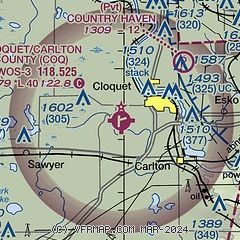
|
CAUTION: Diagram may not be current

| Airport distance calculator |
|---|
|
|
| Sunrise and sunset |
|---|
|
Times for 16-Apr-2025
| | Local
(UTC-5) | | Zulu
(UTC) |
|---|
| Morning civil twilight | | 05:50 | | 10:50 |
| Sunrise | | 06:22 | | 11:22 |
| Sunset | | 19:58 | | 00:58 |
| Evening civil twilight | | 20:30 | | 01:30 |
|
| Current date and time |
|---|
| Zulu (UTC) | 16-Apr-2025 09:58:11 |
|---|
| Local (UTC-5) | 16-Apr-2025 04:58:11 |
|---|
|
| METAR |
|---|
| KCOQ | 160955Z AUTO 00000KT 10SM CLR M02/M05 A3008 RMK AO2 TSNO
|
KDLH
15nm NE | 160855Z 00000KT 10SM CLR M02/M05 A3009 RMK AO2 SLP209 T10221050 55002 $
|
KDYT
19nm E | 160955Z AUTO 00000KT 10SM FEW049 M01/M02 A3012 RMK AO2
|
|
| TAF |
|---|
KDLH
15nm NE | 160525Z 1606/1706 07004KT P6SM FEW200 FM161400 12009KT P6SM FEW150 FM162100 10012G18KT P6SM FEW150
|
|
| NOTAMs |
|---|
NOTAMs are issued by the DoD/FAA and will open in a separate window not controlled by AirNav.
|
|


