FAA INFORMATION EFFECTIVE 20 MARCH 2025
Location
| FAA Identifier: | CWV |
| Lat/Long: | 32-11-42.2030N 081-52-09.5430W
32-11.703383N 081-52.159050W
32.1950564,-81.8693175
(estimated) |
| Elevation: | 111.6 ft. / 34.0 m (surveyed) |
| Variation: | 07W (2020) |
| From city: | 3 miles NE of CLAXTON, GA |
| Time zone: | UTC -4 (UTC -5 during Standard Time) |
| Zip code: | 30417 |
Airport Operations
| Airport use: | Open to the public |
| Activation date: | 04/1971 |
| Control tower: | no |
| ARTCC: | JACKSONVILLE CENTER |
| FSS: | MACON FLIGHT SERVICE STATION |
| NOTAMs facility: | MCN (NOTAM-D service available) |
| Attendance: | MON-FRI 0815-1500 |
| Wind indicator: | lighted |
| Segmented circle: | yes |
| Lights: | ACTVT REIL RWY 10 & 28; PAPI RWYS 10 & 28 - CTAF. MIRL RWY 10/28 PRESET LOW INTST; TO INCR INTST & ACTVT AFTER 2200 - CTAF. |
| Beacon: | white-green (lighted land airport)
Operates sunset to sunrise. |
Airport Communications
| CTAF/UNICOM: | 122.8 |
| WX AWOS-3: | 120.075 (912-739-3768) |
| WX AWOS-3PT at MHP (15 nm NW): | 120.3 (912-685-2729) |
| WX AWOS-3PT at RVJ (17 nm SW): | 128.325 (912-557-0011) |
| WX AWOS-3 at TBR (19 nm N): | 119.025 (912-764-9321) |
- APCH/DEP SVC PRVDD BY JACKSONVILLE ARTCC ON FREQS 132.925/363.2 (SAVANNAH RCAG).
Nearby radio navigation aids
| VOR radial/distance | | VOR name | | Freq | | Var |
|---|
| SAVr281/34.2 | | SAVANNAH VORTAC | | 115.95 | | 06W |
| SVNr289/38.6 | | HUNTER VOR/DME | | 111.60 | | 02W |
| NDB name | | Hdg/Dist | | Freq | | Var | | ID |
|---|
| BULLO | | 223/16.8 | | 407 | | 05W | | BZQ | -... --.. --.- |
| ONYUN | | 101/21.8 | | 372 | | 06W | | UQN | ..- --.- -. |
| BAXLEY | | 048/39.3 | | 376 | | 06W | | BHC | -... .... -.-. |
Airport Services
| Fuel available: | 100LL |
| Parking: | tiedowns |
| Airframe service: | NONE |
| Powerplant service: | NONE |
| Bottled oxygen: | NONE |
| Bulk oxygen: | NONE |
Runway Information
Runway 10/28
| Dimensions: | 5151 x 75 ft. / 1570 x 23 m |
| Surface: | asphalt, in good condition |
| Weight bearing capacity: | |
| Runway edge lights: | medium intensity |
| RUNWAY 10 | | RUNWAY 28 |
| Latitude: | 32-11.694458N | | 32-11.712282N |
| Longitude: | 081-52.658455W | | 081-51.659638W |
| Elevation: | 111.5 ft. | | 98.3 ft. |
| Traffic pattern: | left | | left |
| Runway heading: | 096 magnetic, 089 true | | 276 magnetic, 269 true |
| Displaced threshold: | 500 ft. | | no |
| Markings: | nonprecision, in good condition | | nonprecision, in good condition |
| Visual slope indicator: | 2-light PAPI on left (3.00 degrees glide path) | | 2-light PAPI on left (3.00 degrees glide path) |
| Runway end identifier lights: | yes | | yes |
| Touchdown point: | yes, no lights | | yes, no lights |
| Obstructions: | 18 ft. road, 414 ft. from runway, 282 ft. left of centerline, 11:1 slope to clear
RWY 10 - 20:1 SLP TO DSPLCD THLD. | | 89 ft. trees, 2514 ft. from runway, 121 ft. left of centerline, 26:1 slope to clear |
Airport Ownership and Management from official FAA records
| Ownership: | Publicly-owned |
| Owner: | CITY OF CLAXTON
BOX 33
CLAXTON, GA 30417
Phone 912-739-1712 |
| Manager: | VERNON OWENS, AIRPORT MANAGER
389 AIRPORT ROAD
CLAXTON, GA 30417
Phone 912-739-0124 |
Additional Remarks
| - | FOR CD CTC JACKSONVILLE ARTCC AT 904-845-1592. |
Instrument Procedures
NOTE: All procedures below are presented as PDF files. If you need a reader for these files, you should download the free Adobe Reader.NOT FOR NAVIGATION. Please procure official charts for flight.
FAA instrument procedures published for use from 20 March 2025 at 0901Z to 17 April 2025 at 0900z.
IAPs - Instrument Approach Procedures |
|---|
| RNAV (GPS) RWY 10 **CHANGED** | |
download (193KB) |
| RNAV (GPS) RWY 28 **CHANGED** | |
download (222KB) |
| NOTE: Special Alternate Minimums apply | |
download (140KB) |
| NOTE: Special Take-Off Minimums/Departure Procedures apply | |
download (594KB) |
Other nearby airports with instrument procedures:
KMHP - John Edwin Jones Sr Field/Metter Municipal Airport (15 nm NW)
KRVJ - Swinton Smith Field at Reidsville Municipal Airport (17 nm SW)
KTBR - Statesboro-Bulloch County Airport (19 nm N)
KLHW - Wright Army Airfield (Fort Stewart)/Midcoast Regional Airport (24 nm SE)
KVDI - Vidalia Regional Airport (25 nm W)
|
|

Road maps at:
MapQuest
Bing
Google
| Aerial photo |
|---|
WARNING: Photo may not be current or correct
 Photo by Jim Lewis
Photo taken 05-May-2006
Photo by Jim Lewis
Photo taken 05-May-2006
Do you have a better or more recent aerial photo of Claxton-Evans County Airport that you would like to share? If so, please send us your photo.
|
| Sectional chart |
|---|
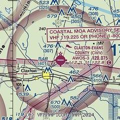
|
| Airport distance calculator |
|---|
|
|
| Sunrise and sunset |
|---|
|
Times for 13-Apr-2025
| | Local
(UTC-4) | | Zulu
(UTC) |
|---|
| Morning civil twilight | | 06:37 | | 10:37 |
| Sunrise | | 07:02 | | 11:02 |
| Sunset | | 19:54 | | 23:54 |
| Evening civil twilight | | 20:19 | | 00:19 |
|
| Current date and time |
|---|
| Zulu (UTC) | 13-Apr-2025 18:03:37 |
|---|
| Local (UTC-4) | 13-Apr-2025 14:03:37 |
|---|
|
| METAR |
|---|
| KCWV | 131755Z AUTO VRB01KT 10SM CLR 20/05 A3015 RMK AO2 10209 20077
|
KMHP
15nm NW | 131755Z AUTO 00000KT 10SM CLR A3016 RMK AO2 10202 20094
|
KRVJ
17nm SW | 131755Z AUTO 00000KT 10SM CLR 21/04 A3016 RMK AO2 T02140039 10217 20071
|
KTBR
19nm N | 131755Z AUTO 00000KT 10SM CLR A3016 RMK AO2
|
|
| TAF |
|---|
KSAV
34nm E | 131724Z 1318/1418 27007KT P6SM SKC FM132330 17008KT P6SM SKC FM140300 21003KT P6SM SKC FM141300 24009KT P6SM SKC
|
|
| NOTAMs |
|---|
NOTAMs are issued by the DoD/FAA and will open in a separate window not controlled by AirNav.
|
|


